Download
1 / 21
220 likes | 363 Views
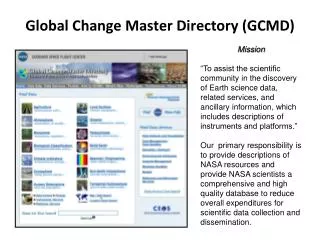
The Global Change Master Directory (GCMD) is a vital resource enabling users to locate and access over 15,000 descriptions of Earth science datasets and services related to global change research. Launched by NASA in 1987, GCMD provides discovery-level metadata for datasets from various sources, emphasizing data and service discovery. Its collaborations with federal agencies and international organizations enhance its utility. GCMD also offers robust data management services, ensuring the accuracy and relevance of its extensive metadata collections.

E N D
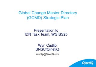
The Global Change Master Directory http://globalchange.nasa.gov John Porter, Univ. Virginia
Roadmap • GCMD – Goals, Holdings, Users & Collaborations • Data Discovery Technologies • The Directory Interchange Format (DIF) • Existing Crosswalks
Global Change Master Directory (GCMD) • The goal of the GCMD is “to enable users to locate and obtain access to Earth science data sets and services relevant to the global change and Earth science research” • “The GCMD database holds more than 15,000 descriptions of Earth science data sets and services covering all aspects of Earth and environmental sciences.” - http://globalchange.nasa.gov • The GCMD has been online since 1987 (initially as the NASA Master Directory)
GCMD Focus • The focus of the GCMD is on Data and Service Discovery • It provides discovery-level metadata for datasets and services from a variety of federal and non-federal sources • Data relevant to global change research is broadly defined to include most ecological data • GCMD does not house or maintain the actual datasets themselves • GCMD has staff specifically devoted to entry and curation of data set descriptions
Services • Services - “descriptive information about commercial and non-commercial data services that assists its user community in analyzing, processing, and evaluating Earth science data sets” • “must be specific and directly related to the processing, viewing, analysis, archival, retrieval, production, interpretation, acquisition, formatting, or indexing of Earth science data” (http://globalchange.nasa.gov) • Uses Service Entry Resource Format (SERF) • Similar to DIF
Metadata Holdings Over 15,000 datasets and collections documented. Over 1,000 Earth Science Services documented.
Types of Data Represented Major Topics: Atmosphere, Biosphere, Land Surface, Human Dimensions
Modifications New Deleted Active management of Metadata Metadata is not simply accumulated. Metadata is modified and even deleted on a on-going basis to assure that it is current and accurate.
Number of Unique Hosts Users – over 3M hits in 2004
Collaborations • NASA collaborations • NASA Earth Observing System Data Information System (EOSDIS) • Federation of Earth Science Information Partners (ESIP) • NASA's Geospatial One-Stop • U.S. Government Federal Agency Collaborations • Biological Resources Division, US Geological Survey/NBII • National Oceanic and Atmospheric Administration (NOAA) • Intergovernmental Collaborations • National Spatial Data Infrastructure/Federal Geographic Data Committee (NSDI/FGDC) • Data Management and Communications (DMAC)
International Collaborations • Committee on Earth Observation Satellites International Directory Network (CEOS IDN) • Antarctic Master Directory • United Nations Environmental Programme (UNEP) • The Global Observing Systems Information Center (GOSIC) • The International Oceanographic Data and Information Exchange (IODE) • Global Ecosystems Dynamics Program (GLOBEC)
Topic-based browsing of datasets Free text search of datasets Keyword, Spatial and Temporal searches Browse services Free text search of services Additional searches
Portals Portals provide customized access to project-specific or topic-specific metadata
docBuilder – Metadata Entry Use an existing Data Center or Add a new one!
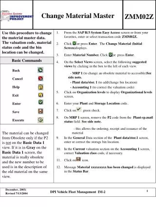
Entry ID Entry Title Parameters (Science Keywords)* ISO Topic Category Data Center* Summary Metadata_Name Metadata_Version Personnel Data Set Citation Instrument* Platform Temporal Coverage Paleo-Temporal Coverage Data Set Progress Spatial Coverage Location* Data Resolution Project Keyword Quality Access Constraints Use Constraints Data Set Language Originating Center* Distribution Multimedia Sample Reference Discipline Related URL Parent DIF* IDN Node* DIF Creation Date Last DIF Revision Date DIF Revision History Future DIF Review Date * controlled vocabulary Directory Interchange Format -DIF
DIF characteristics • Although DIFs pre-date XML, an XML schema is available (http://globalchange.nasa.gov/Aboutus/xml/dif/dif-schema.xml) • “Parameters” have a four-level hierarchy with controlled terms that make up a de facto ontology for organizing data (multiple lists of controlled terms are supported) • Category • Topic • Term • Variable • Keyword (not a controlled term) • For collections of data, DIFs support parent-child relationships • Allowing users to query at both the collection and the individual dataset levels
Existing Crosswalks from/to DIF • The ISO 19115/TC 211 Geographic Information/Geomatics Metadata Standard • DIF to ISO 19115 Mapping • FGDC/ISO Metadata Standard Harmonization • Federal Geographic Data Committee (FGDC) Content Standard for Digital Geospatial Metadata • Directory Interchange Format fields mapped to FGDC fields • The GeoConnections Discovery Portal (formerly CEONet) • Directory Interchange Format fields mapped to FGDC fields
Existing Crosswalks from DIF • The Z39.50 Search and Retrieval Protocol • GCMD MD-Isite implementation of Z39.50 • The Catalogue Interoperability Protocol (CIP) • The National Biological Information Infrastructure (NBII) • The Dublin Core Metadata Initiative • Directory Interchange Format fields mapped to the Dublin Core Element Set • The Australia New Zealand Land Information Council (ANZLIC) • Directory Interchange Format fields mapped to the ANZLIC fields
GCMD and EML • GCMD has done test imports of EML documents using the GCE LTER site • Manual element: Assignment of Parameters (Science Keywords) from GCMD valids list
Thanks! • Lola Olsen • Gene Major • Cheryl Solomon