Download
1 / 12
130 likes | 309 Views
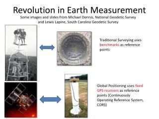
Revolution in Earth Measurement. Some images and slides from Michael Dennis, National Geodetic Survey and Lewis Lapine , South Carolina Geodetic Survey. Traditional Surveying uses benchmarks as reference points.

E N D
Revolution in Earth Measurement Some images and slides from Michael Dennis, National Geodetic Survey and Lewis Lapine, South Carolina Geodetic Survey Traditional Surveying uses benchmarks as reference points Global Positioning uses fixed GPS receivers as reference points (Continuously Operating Reference System, CORS)
Differential GPS • Differential GPS uses the time sequence of observed errors at fixed locations to adjust simultaneous measurements at mobile receivers • A location measurement accurate to 1 cm horizontally and 2cm vertically is now possible in 3 minutes with a mobile receiver • More accurate measurements if the instrument is left in place longer
This leads to adjustments in locations of the national network of survey benchmarks Survey Benchmark {Latitude (f), Longitude (l), Elevation (z)}
Adjustments of the NAD83 Datum Slightly different (f, l) for benchmarks Continuously Operating Reference System Canadian Spatial Reference System National Spatial Reference System High Accuracy Reference Network
THE GEOID AND TWO ELLIPSOIDS CLARKE 1866 (NAD27) GRS80-WGS84 (NAD83) Earth Mass Center Approximately 236 meters GEOID
WGS 84 and NAD 83 North American Datum of 1983 (NAD 83) (Civilian Datum of US) International Terrestrial Reference Frame (ITRF) includes updates to WGS-84 (~ 2 cm) Earth Mass Center 2.2 m (3-D) dX,dY,dZ World Geodetic System of 1984 (WGS 84) is reference frame for Global Positioning Systems GEOID
High Accuracy Reference Network Continuously Operating Reference System http://www.ngs.noaa.gov/faq.shtml Slide: Lewis Lapine
Adjustment using Triangulation of Reference Locations of Various Accuracies
Tectonic Motions This has to take Tectonic Motions into account From Sella et al., 2002
HORIZONTAL TECTONIC MOTIONS Motion in cm/year North American Plate Pacific Plate When is California not in North America … …. when its on the Pacific Plate!
What’s in a name? That which we call a datumBy any other name would smell as sweet… • NAD 83(2011) epoch 2010.00 • “2011” is datum tag year adjustment complete • “2010.00” is “epoch date” (January 1, 2010) • Date associated with coordinates of control station • Frame fixed to North American tectonic plate • Includes California, Alaska, Puerto Rico, and US Virgin Islands • NAD 83(PA11) epoch 2010.00 • Frame fixed to Pacific tectonic plate (Hawaii and American Samoa) • NAD 83(MA11) epoch 2010.00 • Frame fixed to Mariana tectonic plate (Guam and CNMI) The latest datum adjustments are referenced to location on a particular tectonic plate