Download
1 / 22
220 likes | 429 Views
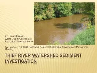
By: Corey Hanson, Water Quality Coordinator, Red Lake Watershed District For: January 10, 2007 Northwest Regional Sustainable Development Partnership Meeting. Thief River Watershed Sediment Investigation. Marshall County Water Resources Advisory Committee

E N D
By: Corey Hanson, Water Quality Coordinator, Red Lake Watershed District For: January 10, 2007 Northwest Regional Sustainable Development Partnership Meeting Thief River Watershed Sediment Investigation
Marshall County Water Resources Advisory Committee Red River Basin Water Quality Team December 15, 2005 Impoundment Meeting Part of Marshall County Water Plan and the RLWD 10-Yr Plan Project Origin
Sedimentation in the Thief River Falls Reservoir Large flushes of suspended solids and nutrients during releases from Agassiz NWR Streambank/ditch erosion and sedimentation Channelization Flooding Low Dissolved Oxygen Hydrogen Sulfide Problems
Thief lake Deltas Moose River Spillway Ditch
Red Lake Watershed District Long-Term Monitoring Program • Identification of impairments • Monitoring by Marshall County • Investigative monitoring • Created more questions than answers • Complaints about poor water quality How were problems identified
Is Agassiz NWR really cause of water quality problems in the Thief River or does the problem come from what is entering the refuge? • Influence of the Mud River? • How often does turbidity increase between Thief Lake and Agassiz NWR and what is causing this problem? Is this reach impaired? • Are ditches contributing to the Thief River water quality problems? • What happens during runoff events? • How is the rate of release from Agassiz Pool to the quality of water being released from the pool? Questions That will Be Addressed
Intensive study that includes continuous monitoring. • Focus on Thief Lake and Agassiz NWR • Input vs Output • TIMING • Sediment Budgets • Coordination • Maintenance Suggested Solutions
Purchase Equipment • Equipment calibration and maintenance • Water quality monitoring • Flow monitoring • Data entry and reduction • Develop sediment budget • Water quality modeling • Assess Results • Make recommendations • Write and review report • Publish Report • Develop impaired waters work plans Project Objectives
February 2007 – February 2010 • Continuous monitoring in open water months of all years. • Equipment installed as soon as possible. • Monthly sampling (at least) • FLUX and SWAT Modeling will be done near the end of the project so that monitoring data may be used Timeline
Encouraged by Molly MacGregor of the MPCA to apply for a Clean Water Partnership Resource Investigation Grant. • MPCA Approved $96,500 in Funding for the Project ($193,000 total budget) • Cash Match from RLWD • In-kind support • Marshall County Water Plan, USFWS, DNR, Pennington County • Red River Watershed Management Board? Funding
Continuous Monitoring • Sampling • Flow Rating Curves • Streamgauging • Data Analysis • Modeling • Flux • SWAT • Verification of existing impairments, ID of new ones Monitoring Plan
Eureka Manta Logging sondes with optical dissolved oxygen, turbidity, and water depth added. • At least 5 or 6 sites • Water level loggers at other sites • 2 to 5 sites • Weather Continuous Monitoring
11 sites Sampling by the RLWD and the Marshall Co. Water Plan Total suspended solids Total phosphorus and orthophosphorus E-Coli Field Measurements Turbidity Dissolved Oxygen More Sampling
Soil and Water Assessment Tool • Basic Tasks • Model Development, Calibration, and Validation • Water Quality Assessment • Identification of Target Areas and BMPs • Evaluation of Hypothetical BMP Implementation • Compilation of Results Modeling
Getting a grant agreement to sign • Creating a detailed work plan and budget • Review past studies/projects • Piggyback Projects • Monitoring by Agassiz NWR • At outlet from Agassiz Pool to Ditch 11 • Ditch 11 above Agassiz Pool • Ditch 11 Erosion Control Next Steps
Corey Hanson Water Quality Coordinator Red Lake Watershed District 102 Main Ave N P.O. Box 803 Thief River Falls, MN 56701 Phone: 218-681-5800 Cell: 218-686-9691 Email: coreyh@wiktel.com Website: www.redlakewatershed.org Contact Information