Download

1 / 31
310 likes | 520 Views
Estimation of Accumulated Upstream Drainage Values in Braided Streams Using Augmented Directed Graphs. Lawrence Stanislawski, Science Applications International Corporation (SAIC) Michael Finn, U.S. Geological Survey Michael Starbuck, U.S. Geological Survey

E N D
Estimation of Accumulated Upstream Drainage Values in Braided Streams Using Augmented Directed Graphs Lawrence Stanislawski, Science Applications International Corporation (SAIC) Michael Finn, U.S. Geological Survey Michael Starbuck, U.S. Geological Survey E. Lynn Usery, U.S. Geological Survey Patrick Turley, U.S. Geological Survey 2006 AutoCarto Conference, June 25-28. Vancouver, WA
Overview of The National Map National Hydrography Dataset (NHD) – drainage network Generalization Process for NHD Pruning of Drainage Network Methods Augmented Directed Graph Brute Force Tracing Test Results Summary 2006 AutoCarto Conference, June 25-28. Vancouver, WA
Consistent framework for geographic knowledge needed by the • Nation • Provides public access to high-quality, geospatial data and • information from multiple partners to help support decision- • making by resource managers and the public. • Product of a consortium of Federal, State, and local partners • who provide geospatial data to enhance America's ability to • access, integrate, and apply geospatial data at global, national, • and local scales. • Includes eight primary data themes: • Orthoimagery, • Elevation, • Hydrography, • Transportation, • Structures, • Boundaries, • Geographic names, • Land use/land cover, • Most themes are populated, and content will continue to be • added and updated The National Map 2006 AutoCarto Conference, June 25-28. Vancouver, WA
Created from many data sources and Web Map Services (WMS) • owned by many organizations. • Data sources are electronically stored at various scales and • resolutions. Consequently, when data are extracted from several WMS and horizontally integrated in geospatial data applications, the differences between data sources become apparent. • The ability to render one or more scales of The National Map data into an appropriate, or functionally equivalent, representation at a user-specified scale could substantially enhance analysis capabilities of these data. • Research Topic: development of automated generalization approach that renders a functionally equivalent dataset at a user-specified scale, focusing on the National Hydrography Dataset (NHD) layer of The National Map. The National Map 2006 AutoCarto Conference, June 25-28. Vancouver, WA
National Hydrography Dataset • Vector data layer of The National Map representing surface waters of the United States. • Includes a set of surface water reaches • Reach: significant segment of surface water having similar hydrologic characteristics, such as a stretch of river between two confluences, a lake, or a pond. • A unique address, called a reach code, is assigned to each reach, which enables linking of ancillary data to specific features and locations on the NHD. Reach code from Lower Mississippi subbasin 08010100000413 region-subregion-accounting unit-subbasin-reach number 08010100000413 The National Map National Hydrography Dataset (NHD) 08010100000696 2006 AutoCarto Conference, June 25-28. Vancouver, WA
Linear Canal/Ditch Areal Lake/Pond Linear Streams Areal Stream/River Linear Connector Areal Lake/Pond NHD Features Artificial Paths
National Hydrography Dataset • Divided and distributed at watershed basin and subbasin boundaries. • Stored in an ArcGIS geographic database (geodatabase) model. • Three levels of detail (resolutions) • Medium (1:100,000-scale source) • only complete layer • High (1:24,000-scale source) • three-quarters complete • Local (1:12,000 or larger source) The National Map National Hydrography Dataset (NHD) Subregions along northern shore of Gulf of Mexico 2006 AutoCarto Conference, June 25-28. Vancouver, WA
Develop a generalization strategy that can be implemented on subsets of the NHD. • Strategy should produce a dataset in the NHD model format that maintains: • feature definitions, • reach delineations, • feature relationships, and • flow connections between remaining generalized features. • Extracted dataset should function with NHD applications • less detail • faster processing speed • Extracted level of detail: • user-specified Generalization Development of such a generalization process could eliminate the need to store and maintain all but the highest resolution NHD data layer. 2006 AutoCarto Conference, June 25-28. Vancouver, WA
Base data: highest resolution NHD that covers desired area. • Feature pruning – removal of features that are too small for desired output scale. • select a subset of network features • select a subset of area features • remove point features associated with pruned line or area features • Feature simplification • removal of vertices • aggregation, amalgamation, merging, etc. • Focus: network pruning Generalization 2006 AutoCarto Conference, June 25-28. Vancouver, WA
Gasconade-Osage subregion (1029) falls in the Interior Plains and Interior Highlands physiographic divisions. Generalization: Network Pruning Example 2005 ESRI International User Conference, July 25-29. San Diego, CA.
Feature pruning – removal of feature that are too small for desired output scale. • select a subset of network features Generalization: Network Pruning Example Pruning test on Gasconade-Osage subregion (1029) Green: 1:100,000 Blue: 1:500,000 Red: 1:2,000,000 2006 AutoCarto Conference, June 25-28. Vancouver, WA
Simple Hydrographic Network 2006 AutoCarto Conference, June 25-28. Vancouver, WA
Braided Network 2006 AutoCarto Conference, June 25-28. Vancouver, WA
Complex Coastal Area Network with Cycles 2006 AutoCarto Conference, June 25-28. Vancouver, WA
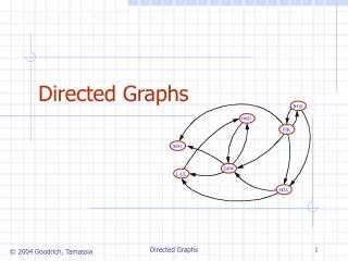
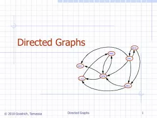
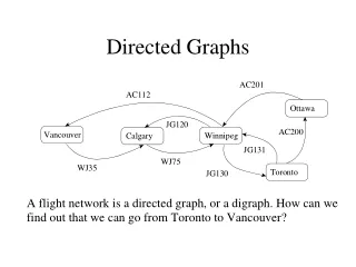
Directed Graphs Vector Data Layer • Nodes • Directed Edges (Arcs) • Direction represents flow
a,(a) (a+b) b,(b) e,(a+b+e) (c+d) c,(c) f, (c+d+f) d,(d) Upstream Drainage Area (a+b+c+d+e+f)
Methods • Brute Force Trace – Traces upstream from each node summing up all drainage areas that are encountered. • Accurate • Slow • Augmented Directed Graph Method – Exploits the Arc Suite polygon data structure within the coverage model, and utilizes a system of tables to arrive at a faster end result. • Approximately 20x-40x faster • Needs more tests run to discover accuracy 2006 AutoCarto Conference, June 25-28. Vancouver, WA
Augmented Directed Graph Method (One-in-one-out polygon) a,(a) (a) b,(a+b) c,(c+a) (a) (a+b+a+c-a) 2006 AutoCarto Conference, June 25-28. Vancouver, WA
Augmented Directed Graph Method (One-in-mulitple-out polygon) N2 b,(a+b,T1) (d+e+f+h,T3) h d f a,(a) (a,T1) N3 (d+e+f,T2) e N1 i T3 = T1 = c,(a+c,T1) N4 T2 = (d+e+f+i,T4) T4 = 2006 AutoCarto Conference, June 25-28. Vancouver, WA
Node: Sum = Sum – ((Freq – 1) * Value) Augmented Directed Graph Method (Convergence with tables) z,(a+b+c+z,T1) T3 = T1 = (a+b+c+z+a+b+c+y,T3) ∀ ∀ N2 (a+b+c+z+y,T3) y,(a+b+c+y,T2) T2 = 2006 AutoCarto Conference, June 25-28. Vancouver, WA
The Cycle Complex • Cycles have proven to be the biggest obstacle we have had to overcome • It is important to notice that all arcs on a cycle will have the same upstream drainage area • Tables should also be resolved and maintained throughout every edge of the cycle complex in question • Cycles are the main reason for the fluctuation in speed of the augmented graph method 2006 AutoCarto Conference, June 25-28. Vancouver, WA
Future Work • Convert program to C++ • Use ArcObjects to keep the same functionality without reinventing the wheel • ArcObjects allows the programmer to have more control. This will allow the programmer to remove unnecessary steps • Implement a parallel processing scheme • Begin processing on the sub basin level • This scheme would increase the speed of the process by the number of processors in the cluster with a maximum of the number of sub basins in the United States 2006 AutoCarto Conference, June 25-28. Vancouver, WA
Build a polygon to critical node table – table identifies the one-in-one-out and many-out polygons and the associated nodes. • 2. For each edge flowing out of a zero in-degree node, set the edge sum equal to the value assigned to the edge, and push the edge sum to the sum on the downstream node. • 3. At each convergent node with a complete in-flowing edge sum, process converging tables as needed to reduce the node sum. • 4. At each convergent node with a complete in-flowing edge sum, that also closes a one-in-one-out polygon, reduce the node sum by the value assigned to the associated divergent polygon. • 5. At each divergent node of a one-in-one-out polygon, assign the node value to the associated one-in-one-out polygon, but reduce the node value by values in the associated node table, if one exists. • 6. For each edge flowing out of a node with a completed sum, add the node sum to the edge value and push this value into the sum on the downstream node. • 7. Repeat steps 3-6 until all edges have values, or cycles are encountered. • 8. If any cycles are found, process each cycle complex separately. For each cycle complex, trace upstream edges from one node in the cycle and assign the sum of the traced edges to one edge in the cycle complex. Repeat steps 3-6 in a special way for all cycle edges. • 9. Repeat step 3-8 until all edges have values. Outline of Augmented Directed Graph Algorithm 2006 AutoCarto Conference, June 25-28. Vancouver, WA
Results • Fabricated dataset • Brute force same as ADG on all arcs (diff < 0.001 sq km). • 111 arcs, 1 cycle complex • Monotonically Increasing: All tnode values >= edge values. • Record FREQUENCY MIN-UPSTR_SQ_KM MAX-UPSTR_SQ_KM • 1 111 0.33288 4577.87846 2006 AutoCarto Conference, June 25-28. Vancouver, WA
Results Pomme De Terre subbasin (10290107) in Gasconade-Osage Region of Missouri (no cycles) Brute force same as ADG on all arcs (diff < 0.001 sq km). Monotonically Increasing: All tnode values >= edge values. Record FREQUENCY MIN-UPSTR_SQ_KM MAX-UPSTR_SQ_KM 1 5580 0.02371 2190.40134 2006 AutoCarto Conference, June 25-28. Vancouver, WA
Results Lower Potomac. Maryland, Virginia (0207011) (at least 1 cycle) Brute force same as ADG on all arcs (diff < 0.001 sq km). Brute force started ~9 (21:00) pm 06/22/2006 ended 1:47 Elapsed time ~3.75 hours (225 minutes) = ~53 edges/minute. Monotonically Increasing: All tnode values >= edge values. Record FREQUENCY MIN-UPSTR_SQ_KM MAX-UPSTR_SQ_KM 1 12039 0.00215 4851.19298 2006 AutoCarto Conference, June 25-28. Vancouver, WA
Eastern Louisiana Coastal (3 cycle complexes) ADG less than Brute force by more than 0.001 sq km on two arcs Record BF_UPSTR_SQKM UPSTR_SQ_KM DIFF 10185 27.5474 27.5747 0.02733 10421 11.3602 11.3875 0.02733 Brute force ~ 30 edges/minute). ADG - 65 minutes (~500 edges/minute). Monotonic Increasing: All tnode values >= edge values. Record FREQUENCY MIN-UPSTR_SQ_KM MAX-UPSTR_SQ_KM 1 31149 0.00044 963.73358 2006 AutoCarto Conference, June 25-28. Vancouver, WA
Results demonstrate that the augmented directed graphh algorithm can accurately accumulate values associated with the edges of a graph by accumulating them with the direction of flow. The algorithm has the following properties: • iteratively pushes values downstream from multiple starting points, traversing each graph feature once (except when cycles exist), • tracks duplicate values on divergent edges and removes the duplicates at convergent nodes, • provides monotonically increasing (non-decreasing) values with downstream location on the graph,and • Identifies and handles cycle subsystems in the graph. • From a data processing perspective, the ADG approach appears to be a substantial improvement over existing graph traversal techniques that provide less precise proportioning alternatives for handling duplication at divergences. Summary 2006 AutoCarto Conference, June 25-28. Vancouver, WA
The ADG approach is tailored for data that is properly oriented in the directed graph data structure. Inaccurate results or failed processing are likely when edge features are oriented improperly. Additional testing will be completed to validate this procedure and identify any limitations. In the future, we will use this approach to generate values for the subsequent pruning process in our generalization strategy for the NHD layer of The National Map. Upstream drainage areas from the ADG algorithm may also be used to estimate stream flow volumes on network features. Alternative uses for ADG processing of network geospatial data are likely to be identified. Summary 2006 AutoCarto Conference, June 25-28. Vancouver, WA
Cormen, T., Leiserson, C., Rivest, R., and Stein, C. 2003. Introduction to Algorithms, 2nd Edition. The MIT Press, Cambridge, Ma. Manber, U. 1989. Introduction to Algorithms: A Creative Approach. Addison-Wesley Publishing Co. McCracken, D., and W. Salmon. 1987. A second course in computer science with Modula-2. New York, New York: John Wiley and Sons. McMaster, R., and K. Shea. 1992. Generalization in digital cartography. Association of American Geographers. Washington, D.C. U.S. Geological Survey. 2000. The National Hydrography Dataset: Concepts and Contents. Accessed May 5, 2006, at URL http://nhd.usgs.gov/chapter1/index.html References 2006 AutoCarto Conference, June 25-28. Vancouver, WA
Questions?Estimation of Accumulated Upstream Drainage Values in Braided Streams Using Augmented Directed Graphs Lawrence Stanislawski, lstan@usgs.gov Michael Starbuck, U.S. Geological Survey Michael Finn, U.S. Geological Survey E. Lynn Usery, U.S. Geological Survey Patrick Turley, U.S. Geological Survey 2006 AutoCarto Conference, June 25-28. Vancouver, WA