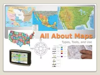
All About Maps
Discover the characteristics and utility of political, physical, and elevation maps. Learn to interpret maps using keys, legends, and compass roses, and identify U.S. states. Explore natural resources and climates with map examples.

All About Maps
E N D
Presentation Transcript
All About Maps Please copy all notes written RED
Learning Targets: • Describe the characteristics and uses of various types of maps, for example: • —political • —physical • —elevation/topographic • —population, population density • —natural resource • —precipitation, climate • • Use a map key/legend, symbols, distance scale, and boundaries to interpret a map. • • Use a compass rose and cardinal or intermediate directions to interpret a map. • • Identify all U.S. states by shape and position on a map.
What is a political map? • Political maps are designed to • - Show governmental boundaries of countries, states, and counties, • Show the location of major cities, • They usually include significant bodies of water. • Bright colors are often used to help the user find the borders.
What is a physical map? • Physical maps are designed to show the physical features of an area • (location of landforms like deserts, mountains and plains.) • country borders • major cities • significant bodies of water • On the linked map in the next slide, note the Pyrenees Mountains, the mountains in central France and the Alps. These types of landforms are not included on political maps.
What is an elevation or topographic map? • The shape of the earth’s surface is shown with contour lines. • Contours are imaginary lines that join points of equal elevation on the surface of the land above or below a reference surface, such as mean sea level. • Contours make it possible to measure the height of mountains, depths of the ocean bottom, and steepness of slopes.
Louisiana topographic map. http://www.lib.utexas.edu/maps/united_states/louisiana_mo_91.jpg
What are natural resources? • This site gives us some answers: • “Natural Resources come from nature and are used to make things that we need.” • http://www.sfenvironment.com/aboutus/school/resources/natural.pdf • They are “materials or substances such as minerals, forests, water, and fertile land that occur in nature and can be used for economic gain.” Oxford Press Dictionary
Map Legend • A map legend is like a • Key to the meaning of • The map. It tells what • All the symbols mean
Compose Rose http://www.enchantedlearning.com/geography/printouts/compassrose.shtml A compass rose is a figure on a compass, map, nautical chart, or monument used to display the orientation of the cardinal directions—North, East, South, and West—and their intermediate points. See if you can • Figure outthe abbreviations that would • go in the other rectangles that • represent the other cardinal and • intermediate directions.