Download
1 / 1
10 likes | 466 Views
LC:. Grasses. Shrubs. Broadleaf forests. Needlleaf forests. Crops. Savanna. Collection 5 QC: Tile h12v04, 10x10 km. N. Shabanov, W. Yang, B.Tan, H. Dong, Y. Knyazikhin, R. Myneni | Boston University, Geography Department | rmyneni@crsa.bu.edu. Abstract. Product Validation.

E N D
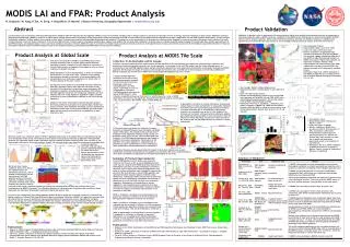
LC: Grasses Shrubs Broadleaf forests Needlleaf forests Crops Savanna Collection 5 QC: Tile h12v04, 10x10 km N. Shabanov, W. Yang, B.Tan, H. Dong, Y. Knyazikhin, R. Myneni | Boston University, Geography Department | rmyneni@crsa.bu.edu Abstract Product Validation Leaf Area Index (LAI) and Fraction of Photosynthetically Active Radiation [400-700 nm] absorbed by vegetation (FPAR) are key environmental variables used in climate research to characterize exchange of fluxes of energy, mass and momentum in Earth system. MODerate resolution Imaging Spectroradiometer (MODIS) provide set of global remote sensing measurements to generate 16 land geophysical products including LAI and FPAR. Current MODIS LAI and FPAR research integrates three major components: LAI and FPAR algorithm development, product analysis and product validation. Product analysis is the central activity, which is closely interconnected with algorithm development and validation. The objective of this presentation is to illustrate this interconnection, targeted for continuous product refinement from Collection 3 through current Collection 4 and into future Collection 5 of the LAI and FPAR products. Product analysis is presented at global scale, regional scale (MODIS tile) and local scale (validation). At global scale we routinely analyzed spatial coverage of the main algorithm, studied seasonality of LAI and FPAR products, and analyzed impact of snow and cloud conditions on product retrievals. MODIS tile scale is convenient for detailed study of product retrievals as function of the algorithm and its input uncertainties and provide direct feedback to algorithm refinement. Finally we summarized reported in peer-reviewed literature results of the validation activities, performed by LAI/FPAR team as well as external validators. Validation, in general, refers to assessment of the uncertainty of higher-level satellite-sensor-derived products by comparison to field measurements scaled to MODIS resolutions. Validation of the MODIS LAI and FPAR products is performed by MODIS LAI/FPAR team as well as external validators. Below results from three validation exercises are detailed. Summary of completed and reported in per-reviewed literature (to the best of our knowledge) validation exercises is given at the end of this section. MODIS LAI and FPAR: Product Analysis • Site: Ruokolahti, Finland • Measurements Dates: June 14-21, 2000 • Land Cover Type: Coniferous forests • Results: Comparison of aggregated high-resolution LAI map and corresponding MODIS LAI retrievals suggests satisfactory behavior of the MODIS LAI algorithm although variation in MODIS LAI product is higher than expected. An improoved correlation between field measurements and reduced simple ratio (RSR) suggests that shortwave infrared (SWIR) may improve accuracy of LAI retrievals for needleaf forests. • Publication: Wang et al. (2004). Evaluation of the MODIS LAI algorithm at a coniferous forest site in Finland. Remote Sensing of Environment, 91, 114-127. Product Analysis at Global Scale Product Analysis at MODIS Tile Scale Collection 3 LAI Anomalies and its Causes: Collection 3 product analysis and field measurements indicate significant LAI overestimation over some areas with herbaceous vegetation and dominance of back-up algorithm retrievals over woody vegetation.Uncertainties in LAI and FPAR product are due to the following resons: a) uncertainties in the LAI/FPAR algorithm inputs (surface reflectance data and land cover map) and b) Uncertainties of the model underlying LAI/FPAR algorithm. We illustrate the impact of the above uncertainties for the three sites: (a) KONZ site in Illinois (Grasses, tile h10v05); b) ARGO site in Kansas (Croplands, tile h11v04) and c) HARV site in Massachusetts (Broadleaf forests, tile: h12v04). ETM+ Surface Reflectances, 1x1 km Collection 3 and Collection 4 MODIS LAI and FPAR products were routinely analyzed as part of product quality control activities: evaluation of spatial coverage of the main algorithm, seasonality of LAI and FPAR products, and analysis of the impact of snow and cloud conditions on product retrievals. Global distribution of LAI, biome-by-biome, is shown for Collection 3 and Collection 4 for July 20-27, 2001. Collection 4 reprocessing improvements resulted in elimination of retrieval anomalies (LAI overestimation) over herbaceous vegetation (for details refer to “Product analysis at tile scale” section ). Key indicator of the quality of LAI and FPAR retrievals is Retrieval Index (RI), defined as ratio of main algorithm retrievals to total retrievals. RI for Collection 4 product was improved by about 20% compared to Collection 3. Biome-by-biome analysis of RI indicate that main algorithm retrievals over herbaceous vegetation are more frequent than over woody vegetation (algorithm is highly sensitive to precision of surface reflectances especially in the case of woody vegetation). Global LAI time series demonstrates expected seasonal variation. The biome profiles have generally the expected shape. Needle leaf forests, however, show anomalous seasonality. Low LAI and Retrieval index during winter time is due to low availability (low solar zenith angle) and poor quality (snow and cloud contamination) of input reflectance data. Patches, 1x1 km Collection 3 Collection 4 1) MODIS LAI/FPAR algorithm references land cover to select vegetation parameters required for LAI retrievals for particular biome type. Land cover misclassification is the first reason, responsible for errors in LAI estimation.Collection 3 LAI/FPAR algorithm referenced at-launch AVHRR based LC, while ETM+ LAI, 1x1 km ETM+ LAI, 10x10 km LAI • Site: Senegal, Western Sudano-Sahelian zone • Measurements Dates: June-November in years 2001 and 2002 • Land Cover Type: grass savanna • Results: Seasonal dynamics of both in situ LAI and FPAR were captured well by MODIS LAI and FPAR. MODIS LAI is overestimated by approximately 2-15% and the overall level of FPAR is overestimated by 8-20% • Publication: Fensholt, R., Sandlholt, I., Rasmussen, M.S. (2004). Evaluation of MODIS LAI, fAPAR and the relation between fAPAR and NDVI in a semi-arid environment using in situ measurements. Remote Sens. Environ. vol. 91, pp. 490-507 At-launch LC: Tile h10v05, 20x20 km LC for Collection 4 LAI: Tile h10v05, 1200x1200 km LC for Collection 4 LAI: Tile h10v05, 20x20 km At-launch LC: Tile h10v05, 1200x1200 km Collection 4 algorithm referencesCollection 3 LC which is based on 1 year of MODIS observations. At-launch LC has significantmisclassification between grasses and broadleaf crops, as can be seen in tile h10v05, which contains KONZ site. 2) Atmospheric correction of surface reflectances only partially reduces impact of clouds and aerosols on data quality. Variations of retrieved LAI were found linearly proportional to variations in surface reflectanes due to uncertainties of atmospheric correction for broadleaf crops in tile h11v04. Quality of LAI retrievals are consistent with input surface reflectance quality: good quality input data translate to low uncertainty of retrieved LAI and vice versa. Therefore, second factor which set limit to the quality of the LAI and FPAR retrievals is precision of surface reflectances. • Site: Alpilles, France • Measurements Dates: February 26 – March 15, 2001 • Land Cover Type: Croplands • Results: Collection 4 MODIS LAI is accurate to within 0.3LAI; precision is 20%, uncertainty is 25%. Biome misidentification deteriorates the accuracy by factor of 2. Results also indicate that small variations in input due to model and observation inaccuracies result in low precision of retrieved LAI. • Publication: Tan et al. (2004). Validation of MODIS LAI product in croplands of Alpilles, France. Journal of Geophysical Research, ( Submitted). Broadleaf Crops: Tile h11v04, 1200x1200 km Collection 5 Collection 4 Collection 4 3) The third reason responsible for Collection 3 product anomalies is mismatch between model simulated and MODIS surface reflectances. This mismatch still cased low rate of Collection 4 main algorithm retrievals during summer over broadleaf forests in tile h12v04, which contains HARV site.Collection 3 LAI/FPAR algorithm parameters were based on SeaWiFS 8-km surface reflectances. Optimization of the algorithm over woody vegetation is complicated due to sensitivity of LAI to uncertainties in surface reflectances. These modifications will be implemented in Collection 5. Collection 4 LUTs: Tile h12v04, 1200x1200 km ETM+ Surface Reflectances, 3x3 km Collection 5 LUTs: Tile h12v04, 1200x1200 km LAI sampling: 3x3 km area Retrievals under snow conditions: about 50-60% of vegetated pixels north of 40 degrees North are identified as having snow during peak winter period. The majority of snow pixels are processed by the back-up algorithm. Main algorithm recognize non vegetation signal in data. Cumulative LAI (LAI x amount of pixels) retrieved under snow condition is 100 times smaller than one for snow free condition. Overall, LAI retrievals under snow should be considered as unreliable (due QC to back-up algorithm retrievals)-they introduce spurious seasonality especially for needle leaf forests. Further improvements of the LAI algorithm are required to improve LAI retrievals for needle leaf forests during boreal winter time. In summary, the above analysis demonstrate the impact of three factors (land cover,surface reflectances and model uncertainties) on the quality of LAI retrievals. We want to emphasis that all three factors combined are responsible for the observed anomalies for each site. QC: LAI, 10x10 km Main Saturation Back-Up Fill Summary of Product Improvements: Summary of Validation: Collection 4 Collection 3 LAI and FPAR algorithm and its inputs were revised for Collection 4 as follows: a) the at-launch AVHRR-based land cover map was replaced with MODIS observation-based LC; b) atmospheric correction of surface reflectanes incorporates improved cloud screening and compositing algorithms, time series of surface reflectances were extended to cover earlier periods of the Terra mission; c) LAI and FPAR algorithm was optimized to better simulate features of MODIS surface reflectances, composting scheme was improved to select best quality retrievals. Collection 4 refinements were focused on improvements of LAI and FPAR retrievals over herbaceous vegetation. Optimization of the algorithm for woody vegetation is more involved (due to saturation of surface reflectances)and will be implemented in Collection 5.Below we review the impact of the above improvements on LAI retrievals for each site. KONZ: a) Collection 3 anomaly of LAI overestimation over grasses was resolved in Collection 4; b) The proportion of best quality main algorithm retrievals was increased. ARGO: a) Collection 3 anomaly of LAI overestimation over croplands was also resolved in Collection 4; b) The proportion of best quality main algorithm retrievals was increased. Some areas have fill values- they will be eliminated in Collection 5. HARV: a) Optimization of the algorithm for woody vegetation is scheduled for Collection 5; b) Results of algorithm optimization over broadleaf forests indicate substantial increase of main algorithm coverage (saturation) and good agreement of retrieved LAI with field measurements. Col. 3 Col. 4 BigFoot Retrievals under cloudy conditions: about 50 to 60% of the vegetated pixels are identified as cloud free, 15% as partially cloudy and 25-35% are cloud covered. LAI/FPAR algorithm performs retrievals regardless of MODIS cloud mask. LAI values retrieved under cloudy condition are spurious. Back-up Grasses: Collection 4, Main, Saturation, Back-Up, Tile h10v05, 1200x1200 km QC QC c d Collection 3 Collection 4 Col. 3 Col. 4 BigFoot retrievals under cloudy conditions indicate bad quality, but main algorithm retrievals may indicate cloud cover overestimation by MODIS cloud mask. The difference between LAI retrieved under cloudy and clear condition is biome dependant, but has biome independent maximum during boreal summer time. • As a part of our collaboration with climate modelers (Robert Dickinson group) we performed comparison of seasonal and spatial variations of LAI and FPAR from MODIS and Common Land Model.Collection 4 MODIS LAI is generally consistent with the CLM during the snow-free periods but may be underestimated in the presence of snow, especially for evergreen forests. On average, the model underestimates FPAR in the Southern Hemisphere and overestimates FPAR over most areas in the Northern Hemisphere compared to MODIS observations during all seasons except northern middle latitude summer. QC QC Collection 5 QC: Tile h12v04, 1200x1200 km Col. 5 BigFoot e July 20-27, 2001 • Publications: • Shabanov et al. (2004). Optimization of the MODIS LAI and FPAR Algorithm Performance over Broadleaf Forests. IEEE Trans. Geosci. Remote Sens., in review. • Huang et al. (2004). Evaluation of Collection 3 MODIS LAI Product with Respect to Input Data Uncertainties – Case Study for Grasses. J. Geophys. Research,(submitted). • Tan et al. (2004). Analysis of Collections 3 and 4 MODIS Broadleaf Crops LAI Products: A Case Study of the Bondville Site. Photogrammetric Engineering and Remote Sensing, (submitted). LAI difference (CLM-MODIS) in July MODIS LAI in July • Publications: • Yang et al. (2004). Analysis of Global MODIS Leaf Area Index and Fraction Absorbed PAR Time Series Data from February 2000 to December 2003. J. Geophysical Research (in review). • Tian et al., (2004). Comparison of seasonal and spatial variations of leaf area index and fraction of absorbed photosynthetically active radiation from Moderate Resolution Imaging Spectroradiometer (MODIS) and Common Land Model. J. Geophys. Research, 109: D01103. Broadleaf forests QC: Collection 5, Tile h12v04, 10x10 km July 20-27, 2001