Download
1 / 11
110 likes | 297 Views
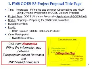
1. FY08 GOES-R3 Project Proposal Title Page. Title : GOES-R Atmospheric Motion Vector (AMV) Research Project Type : Development and Improvement Status : New Duration : 3 Years Leads: Chris Velden – CIMSS (PI) Steve Wanzong -- CIMSS Other Participants :

E N D
1. FY08 GOES-R3 Project Proposal Title Page • Title: GOES-R Atmospheric Motion Vector (AMV) Research • Project Type: Development and Improvement • Status: New • Duration: 3 Years • Leads: • Chris Velden – CIMSS (PI) • Steve Wanzong -- CIMSS • Other Participants: • Jaime Daniels – STAR (Collaborator) • Iliana Genkova -- CIMSS
2. Project Summary • The CIMSS Winds (AMV) Group will use simulated fields from NWP models, and data from GOES Imager and MSG SEVERI to conduct research on deriving AMVs from ‘ABI-like’ data. • It is proposed to perform more in-depth sensitivity studies employing the current NESDIS AMV production algorithm to optimize the tunable settings and examine new resolutions, channels, temporal frequencies, etc. that we will expect with ABI. (Respond to AWG TAC guidance for GOES-RRR needed research) • The research findings from the tasks proposed here will feed into the GOES-R AWG tasks for AMV algorithm implementation.
3. Motivation/Justification • NOAA Mission Goals: • This product development primarily supports: Weather and Water • NOAA-wide Goals: • This product development primarily supports: Satellite Services • Atmospheric Motion Vectors are a principal and vital measurement from geosynchronous orbit. The proposed efforts will address the risk reduction associated with the GOES-R AMV quality assurance. • This research is being conducted to help mitigate the existing limitations of the expected GOES-R AMV product. The research strategies proposed are novel, and promise to improve on the product quality. The proposed tasks also address the GOES-R Risk Reduction plan prepared by STAR, and the recommendations of the AWG Technical Advisory Committee.
4. Methodology • Build on prior experience working with model simulated ABI data - Proxy cases from CIRA, STAR and CIMSS - Focus on “full-disk” case simulated by WRF model • Collect data from MSG SEVERI - Focus on ABI-like spectral channels - Optimize code for traditional AMV tracking channels (IR-W, VIS, WV, SWIR) - Explore potential new spectral bands for AMVs • Employ GOES rapid-scan (~5min) data to simulate and demonstrate expected ABI temporal coverage
5. Summary of Previous Results • Initial demonstration of ABI-like AMVs using 5-min GOES rapid-scan imagery (see following example slide) • Initial demonstration of generating AMVs using existing CIMSS/NESDIS modified code using proxy datasets (presented at recent GOES-R AWG workshop, see following example slide) • Proven concept of 3-D wind fields from simulated GIFTS data (see supplemental slides)
STATUS OF ATMOSPHERIC MOTION VECTOR RESEARCH FOR GOES-R ABI Steve Wanzong1, Wayne Bresky2, Iliana Genkova1, Jaime Daniels3, Christopher S. Velden1, and David A. Santek1 1Cooperative Institute for Meteorological Satellite Studies (CIMSS), Madison, Wisconsin 53706, U.S.A. 2I.M. Systems Group (IMSG), Rockville, Maryland 20852, U.S.A. 3NOAA/NESDIS Office of Research and Applications, NOAA Science Center, Camp Springs, Maryland 20746, U.S.A. Introduction The GOES-R Algorithm Working Group (AWG) Winds team is exploring the most efficient options to derive Atmospheric Motion Vectors (AMV) from expected Advanced Baseline Imager (ABI) observations. Three distinct approaches using automated software will be discussed. The first approach uses the current version of the automated CIMSS/NESDIS AMV retrieval code, and is tested with two simulated ABI datasets from the AWG Proxy team: 1) At CIMSS, a 2km horizontal, 5-minute temporal simulation was run (WRF model) for an hour over the east coast of the United States and into the western Atlantic Ocean. 2) At CIRA, the RAMS model was used to simulate a severe weather event over the Southern Great Plains. TOA radiances from both cases, for ABI channels 8 through 16, were used to create images for the winds retrieval algorithm. AMV computed from heritage channels (IRW and WV) are shown. In addition, the software is being modified with a new ABI calibration module allowing AMV production from non-heritage channels. The second approach uses the level 1 (L1) data output from the Geostationary Cloud Algorithm Testbed (GEOCAT). The calibrated and navigated radiances from GEOCAT are used as direct input into the winds software. Adaptive changes were made to the existing AMV derivation software to accommodate this new data type. AMV using this method is shown. A third method is being considered that would primarily use the GEOCAT framework. The GOES-R AWG winds team is exploring the possibility of using cloud mask and cloud height information output from GEOCAT. The GOES-R AWG Cloud team will provide the cloud mask and cloud height information. Current efforts involve comparing/contrasting GEOCAT pixel-level cloud heights in a target scene against cloud heights computed using algorithms in the current operational AMV software. Preliminary results are shown. Future Work Each of the methods discussed above have a continuing path. The CIMSS/NESDIS AMV retrieval code will be used to work with ABI channels other than the 3.90µm, 6.19µm, 11.2µm, and 13.3µm. Using GEOCAT L1 radiances within the CIMSS/NESDIS AMV retrieval code will require optimization to be operationally feasible. The second approach will incorporate GEOCAT heights as one of the height assignment methods. Continued work on using the GEOCAT framework in its entirety will progress along two paths. The first is to import the functionality of the CIMSS/NESDIS AMV retrieval code into GEOCAT. The second is to use the GOECAT cloud information in the GEOCAT AMV software. OCEANWINDS Several AMV sets were computed to test the sensitivity of the CIMSS/NESDIS wind retrieval code against changes in calibration, noise, navigation, and striping. See Mat Gunshor’s poster for a detailed explanation. The top two AMV plots to the right were calculated from the “Pure” dataset, which consists of unaltered Top of Atmosphere Radiances (TOA), derived from the WRF model. Mid to upper level AMV are show in the left image. Mid to low level AMV are to the right. The sensitivity tests performed involved altering the TOA by adjusting the calibration, noise, navigation and striping instrument specifications singly and in combinations. The resultant AMV calculation shown to the right and on the bottom is a combination of all adjustments at twice the specification. Comparisons to the WRF model U and V have been computed for each AMV set. The statistics were generated using AMV quality controlled using only the Quality Indicator algorithm (qi > 60). A negative speed bias indicates AMV too slow compared to the model. Statistics are shown for AMV generated with a time step of 1/2 hour between each image in the triplet. Pure AMV. TOA Unaltered. CalOffset1K, NoiseFactor1x, NavError1x, Striping1x CalOffset2K, NoiseFactor2x, NavError2x, Striping2x GEOCAT FRAMEWORK Work is progressing in porting the CIMSS/NESDIS AMV retrieval code functionality within the GEOCAT framework. A 4 point centered difference algorithm, which spans 5 pixels in the north/south and east/west direction has been written as a GEOCAT module. The gradient is computed for all cloudy pixels using the GEOCAT cloud mask to delineate cloudy conditions while a gradient mask is used to keep track of local maxima in the gradient magnitude field. Modules for target selection and target quality control are complete. The image below was generated using the IRW channel from GOES-12. The sector contained in the black box is shown in higher resolution below the hemispheric image. The black pixels indicate areas of strong gradients, such as a cloud edge or a coastline. The GOES-12 IRW image is shown for comparison. The gradients on the cloud edge are used as targets for potential AMV tracking. GEOCAT L1 USAGE IN AMV CODE Calibrated and navigated radiances from GEOCAT may be used as input into the CIMSS/NESDIS retrieval software. Operational AMV production uses the McIDAS AREA file format as one of the input data types. Few software changes were necessary to accommodate the GEOCAT data type. The example shown to the right used GEOCAT radiances from a Meteosat-8 triplet centered around 12Z on 4 August 2006. Although not shown, this method compares favorably to the operational AMV. CIRA RAMS SIMULATION The CIMMS/NESDIS wind retrieval algorithm was used to track AMV for a simulated thunderstorm from the CIRA RAMS model. As this was our first proof of concept GOES-R ABI AMV proxy set, it was used to develop the engineering aspect of assimilating new data into the AMV software. It is not optimal because of the dry conditions in the the water vapor channel. To the right are mid to upper level winds using the IRW and WV channel. The mid to low level plot includes AMV from the IRW channel only. GEOCAT CLOUD HEIGHT COMPARISON The GEOCAT cloud height algorithm has not been finalized. To explore the potential for using GEOCAT pixel-level cloud heights at a representative height for each target scene, the CO2 slicing algorithm has been implemented. Preliminary results are to the right. The first image is a plot of GEOCAT CO2 heights available in the L2 output. The second image shows a histogram of differences between the GEOCAT “target” CO2 cloud heights and the CO2 heights computed in the operational AMV software. The GEOCAT “target” heights use the coldest 25% of the 10.7µm BTs. For these coldest pixels, median height is calculated only among the CO2 pixel heights. In general, there is good agreement between the two methods (within +/- 50 hPa). ACKNOWLEDGEMENT: This research is supported by the NOAA Impact of GOES-R instrument project NA07EC0676 at CIMSS. The views, opinions, and findings contained in this report are those of the authors and should not be construed as an official National Oceanic and Atmospheric Administration or U.S. Government position, policy, or decision. Contact Info Jamie Daniels: Jaime.Daniels@noaa.gov
6. Expected Outcomes • Through the simulated ABI AMV products, the GOES-R program office will have a series of examples showing how to maximize the benefit of the expected improvements between the current GOES and GOES-R • An Algorithm Theoretical Basis Document will be created for delivery to the GOES-R AWG AMV application team • Response to the critical research issues associated with GOES-R AMV algorithms and products as identified by the GOES-RRR and AWG TACs
7. Major Milestones • FY08 • Complete initial study of ABI AMVs using proxy datasets • Begin study of ABI-like AMVs using SEVERI data (heritage channels) • Create AMV ATBD (with GOES-R AWG AMV Team) • FY09 • Begin initial study of AMVs from non-heritage spectral bands • Complete study of ABI-like AMVs using SEVERI data (heritage channels) • Update ATBD with new results • FY10 • Complete initial study of AMVs from non-heritage channels • Update ATBD with new results
8. Funding Profile (K) • Summary of leveraged funding • The NOAA/STAR GOES-R AWG project funded some labor time for the initial research exploration of ABI AMVs on the proxy data. However, as suggested by the AWG TAC, this (the basic research component) really belongs on GOES-RRR; hence this leveraged $$ is reduced in 08-10. Note: Increase in requested funding in 08-10 is due to ramp-up of GOES-RRR AMV research (per STAR GOES-RRR Science Plan), reduction in leveraged AWG funding, and response to AWG TAC guidance for needed AMV tasks
9. Expected Purchase Items • FY07 (Under contract) • (75K): STAR Software Contractor (CIMSS) for 1 person at 30% time from JAN 07 to JAN 08 • Personnel Support: Upgrade and Optimize CIMSS/NESDIS AMV algorithms for operation on GOES-R proxy data sets • Travel support for 1 person to AMS Satellite Conference • FY08 • (90K): STAR Software Contractor (CIMSS) for 2 people at 35% time from JAN 08 to JAN 09 • Personnel Support: Conduct studies on proposed GOES-R AMV tasks • 3K -- Travel for 2 people to relevant satellite conference/workshop • FY09 • (90K): STAR Software Contractor (CIMSS) for 2 people at 35% time from JAN 09 to JAN 10 • Personnel Support: Continue research on proposed GOES-R AMV tasks • 3K – Travel for 2 people to relevant satellite conference/workshop • 3K – Publication charges • FY10 • (90K): STAR Software Contractor (CIMSS) for 2 people at 30% time from JAN 10 to JAN 11 • Personnel Support: Continue research on proposed GOES-R AMV tasks • 3K – Travel for 2 people to relevant satellite conference/workshop • 3K – Publication charges