Download
1 / 9
90 likes | 347 Views
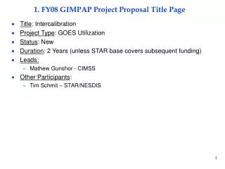
1. FY08 GIMPAP Project Proposal Title Page. Title : Intercalibration Project Type : GOES Utilization Status : New Duration : 2 Years (unless STAR base covers subsequent funding) Leads: Mathew Gunshor - CIMSS Other Participants : Tim Schmit – STAR/NESDIS. 2. Project Summary.

E N D
1. FY08 GIMPAP Project Proposal Title Page • Title: Intercalibration • Project Type: GOES Utilization • Status: New • Duration: 2 Years (unless STAR base covers subsequent funding) • Leads: • Mathew Gunshor - CIMSS • Other Participants: • Tim Schmit – STAR/NESDIS
2. Project Summary • Comparisons of high spectral resolution polar orbiting instruments (AIRS, IASI) to GOES imagers and international geo imagers. • Comparisons of broadband polar-orbiting instruments (HIRS, AVHRR) to GOES imagers and international geo imagers. • CIMSS proposes that the two individual intercalibration tasks be combined into one project. The two tasks, generally thought of as the routine/automated task and the research task, are performed by the same personnel. The routine/automated task was under PSDI until 2007 and then became a second GIMPAP proposal. The primary focus is on researching improved methods and a minimal effort is put into maintaining the automated aspects of GEO/LEO intercalibration. There is international interest in this work when it is done with a high spectral resolution instrument such as AIRS and IASI, but very little interest in the broadband to broadband comparisons. Even so, those are still important for researchers wanting a calibration assessment of older data.
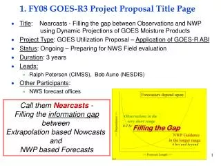
3. Motivation/Justification • Supports NOAA Mission Goal(s): • Climate • Weather and Water • NOAA needs to participate in research promoting and advancing knowledge of intercalibration techniques. • Support for GSICS and NOAA’s larger intercalibration and cal/val efforts. • The method for compensating for AIRS spectral gaps needs to be improved since future high spectral resolution sounders will likely also have spectral gaps in comparison to future imagers.
4. Methodology • AIRS data provided by Walter Wolf • GOES, METEOSAT, MTSAT, AVHRR, and HIRS obtained through the SSEC data center. • IASI data source not yet identified. • For AVHRR/HIRS comparisons to GEOs results are posted to the web daily. • Spectral gaps in AIRS data are filled. • AIRS comparisons to GEOs are done manually with results presented at various conferences (AMS Satellite Conference, SPIE). • Comparisons are made near the GEO subpoint. • Data are spatially smoothed to 100km2
5. Summary of Previous Results • 7 years of prior Intercalibration work spanning across NOAA-14, -15, and -16; GOES-8, -9, -10, -11, -12, and -13; METEOSAT-5, -7, -8, and -9; GMS-5; MTSAT-1R; FY-2C. • Current methodology for Intercalibration was developed under GIMPAP. Methods applied previously to AVHRR and HIRS were adapted to AIRS. Development on AVHRR/HIRS stopped to focus on high spectral resolution methods. • A method for compensating for AIRS spectral gaps was developed.
6. Expected Outcomes • An assessment of the current AIRS gap-filling method. • An improved method for compensating for AIRS spectral gaps. • A comparison of methods used for AIRS and IASI – IASI has spatial gaps that may or may not affect the current method of spatial averaging - the current method may need to be altered to do pixel-to-pixel comparisons. • NOAA is engaging in a broad cal/val project which will, in part, support the international GSICS effort. CIMSS Intercalibration work is adopted by the international GSICS.
7. Major Milestones • FY08 • Improved AIRS gap-filling technique documented in a conference or peer-review paper. • A database of IASI compared with the world’s GEOs started. • FY09 • xx
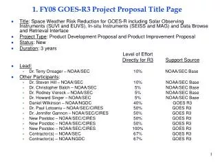
8. Funding Profile (K) • Summary of leveraged funding • PSDI: Spectral Response Function work is closely related to this project. • GOES post-launch science test work includes an intercalibration segment so there is some project overlap there.
9. Expected Purchase Items • FY07 • (51K): xx STAR CICS Grant for 1 people at 45% time from Jan 07 to Dec 07 • AIRS/IASI Comparison to GEOs • AVHRR/HIRS comparisons to GEOs • (33K): xx STAR CICS Grant for 2 people at 25% time from Jan 07 to Dec 07 • Programming Support • (1K): Publications • (1K): Travel • 1 Trip/1 Person/3 Days/Washington DC • FY08 • (55K): xx STAR CICS Grant for 1 people at 50% time from Jan 08 to Dec 08 • AIRS/IASI comparisons to GEOs • AVHRR/HIRS comparisons to GEOs • (33k): xx STAR CICS Grant for 2 people at 25% time from Jan 08 to Dec 08 • Programming Support • (1K): Publications • (1K): Travel • 1 Trip/1 Person/3 Days/Washington DC • FY09 • (59K): xx STAR CICS Grant for 1 people at 50% time from Jan 09 to Dec 09 • AIRS/IASI comparisons to GEOs • AVHRR/HIRS comparisons to GEOs • (34K): xx STAR CICS Grant for 2 people at 25% time from Jan 09 to Dec 09 • Programming Support • (1K): Publications • (1K): Travel • 1 Trip/1 Person/3 Days/Washington DC