Download
1 / 10
100 likes | 331 Views
1. FY10 GOES-R3 Project Proposal Title Page. Title : NearCasts - Filling the gap between Observations and NWP using Dynamic Projections of GOES Moisture Products Project Type : GOES Utilization Proposal – Application of GOES-R ABI

E N D
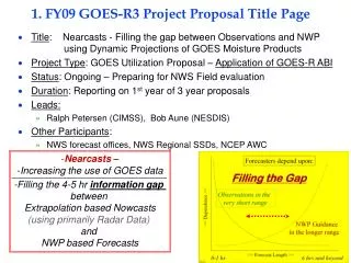
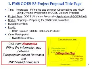
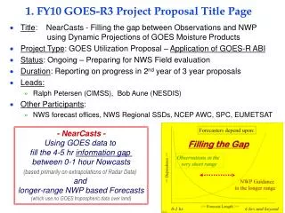
1. FY10 GOES-R3 Project Proposal Title Page • Title: NearCasts - Filling the gap between Observations and NWP using Dynamic Projections of GOES Moisture Products • Project Type: GOES Utilization Proposal – Application of GOES-R ABI • Status: Ongoing – Preparing for NWS Field evaluation • Duration: Reporting on progress in 2nd year of 3 year proposals • Leads: • Ralph Petersen (CIMSS), Bob Aune (NESDIS) • Other Participants: • NWS forecast offices, NWS Regional SSDs, NCEP AWC, SPC, EUMETSAT - NearCasts - Using GOES data to fill the 4-5 hr information gap between 0-1 hour Nowcasts (based primarily on extrapolations of Radar Data) and longer-range NWP based Forecasts (which use no GOES tropospheric data over land) Filling the Gap 0-1 hr 6 hrs and beyond
2. Project Summary – Fundamentally unchanged from 2007-8 Reviews • The overall goal of this project is to provide new tools to help forecasters identify areas where convection is and is not likely 3-6 hours in advance of storm development using moisture and temperature products from future GOES satellites. • Due to the perishability of the information, NearCasts requires numerical approaches that are extremely fast and notably different from those used in numerical weather prediction covering longer time periods. • The new Lagrangian approach to objective NearCasting optimizes the impact and retention of information provided by GOES satellites. • Designed to ingest and preserve extreme vertical and horizontal variations of moisture/temperature observed and updated by GOES • GOES data not currently used in NWP over land • Extremes are under-represented in conventional NWP analyses and forecasts. • NearCasting products include 1-6 hour projections of the GOES multi-layer Moisture & Temperature retrievals, along with predictions of derived areas of convective destabilization. • Existing GOES sounder DPI products used as surrogate for GOES-R ABI • Tests underway using MeteoSat data • Including additional stability indices • Methodology directly transferable to GOES-R • Higher spatial/temporal resolution of ABI products will improve products further.
3. Motivation/Justification – Fundamentally unchanged from 2007/8 Reviews • Supports NOAA Mission Goals: Weather and Water, Commerce & Transportation, Homeland Security, Geostationary Orbiting Environmental Satellite Acquisitions • The NearCasting System adds a short-range forecast component to GOES observations. • An area highlighted in the GOES-R3 program plan • According to the most recent version of the GOES-RRR Plan, Nowcasting applications developments (including the time-range of this project) was included throughout the life of the GOES-RRR program. • Although GOES multi-level DPI moisture observations have been shown to improve upon model first guesses and provide mesoscale detail not available from any other observing system, the data are not used over land in operational numerical forecast system. • As such, previous and ongoing investments in GOES satellites are being underutilized. • This effort uses the GOES moisture/temperature data at full resolution for direct forecaster use • The methodology is directly transferable to GOES-R ABI products • Although the value of GOES IR sounding profiles vanishes after clouds form, the NearCast System anticipates destabilization by dynamically projecting GOES multi-level products to future locations, even after subsequent clouds develop. • Provides evidence of need to support Geostationary Orbiting Environmental Satellite Acquisitions • When used in combination with other conventional data, the hourly-updated NearCast output can help forecasters identify/isolate areas where severe convection is likely to occur 1-6 hours in advance. • Helps reduce size of warning/watch areas, extend lead times of watches/warnings, increases Probability of Detection and reduces False Alarms (non-occurrence)– Weather and Water and Homeland Security Goals • Especially useful for hard-to-forecast isolated summer-time convective events – Commerce and Transportation Goal (especially Aviation)
4. Methodology – Fundamentally unchanged (expanded) from 2007/8 Reviews How Lagrangian NearCasts work: Differentiating where convection can/cannot develop Instead of interpolating (smoothing) randomly spaced moisture/temperature observations to a fixed grid and then calculating moisture changes at the grid points (time consuming), the Lagrangian approach interpolated wind data to locations of full resolution GOES multi-layer moisture & temperature observations and then moves these high-definition data to future locations, using dynamically changing winds with ‘long’ (10 min.) time steps. . The moved ‘obs’ values from each layer are then both: 1) Transferred back to an ‘image’ for display as ‘predicted DPIs’, 2) Combined to produce a variety of derived parameters and 3) Compared between layers to derive various “Stability Indices” that are combined with ‘conventional tools’ to identify mesoscale areas where severe convective will develop even after convective clouds appear. NearCast of Vertical Moisture Gradient (Convective Instability) (900-700 hPa GOES PW -700-500 hPa GOES PW) 3 Hour NearCast : Valid 0000UTC 13 April 2006 – 2100 UTC 900-700 hPa GOES PW 0 Hour Ob Locations 13 April 2006 – 2100 UTC 900-700 hPa GOES PW 3 Hour NearCast Image Verification Updated Hourly - Full-resolution 10 km data - 10 minute time steps
5. Summary of Previous Results – Expanded from 2007/8 Reviews • 1) In past years,Efforts have used GOES-RRR Nowcasting and CIMSS resources to: • Developed and test the new Lagrangian-based dynamical NearCasting Model, • Integrated GOES multi-layer DPI moisture data as a pre-curser for GOES-R ABI data • Developed visualizations to depict predicted DPIs in formats identical to the observations. • Included indications of areas without data in past 6 hours, decreased confidence with time and revalidation as new data become available over time. • WFOs, NWS/CRH and NCEP/AWC agreed to participate in evaluations of the NearCast products. - Evaluation sites prefer data in GRIB-II for use in AWIPS rather than solely as web-based imagery. - Required redirection of visualization efforts to use both AWIPS and N-AWIPS for National Centers and web. • 2) Since last review, • Finalized 24/7 operations at CIMSS • Included GRIB-II and N-AWIPS-based web page graphics • Included 2 layer PW and vertical gradients, as well as multi-layer Theta-E, to better depict Convective Destabilization • Optimized CIMSS GOES Product generation to have NearCasts available within • Developed methodology to remove development of excessive divergence/convergence in Lagrangian wind forecasts • Convergence growth traced to excessive Deformation and Ageostrophy in initial RUC winds • Key to reducing wind errors, expanding areal coverage and extending utility of NearCast beyond 6 hours • Obtained endorsement for NWS SSD Chiefs • At their request, successfully tested system in heavy precipitation cases • Presence at 2009 NSSL Spring Experiment • Positive response from SPC • Greater participation planned for next year • Coordinated with “GOES Proving Ground” effort • Coordinating with EUMETSAT to perform tests with SEVRI data • Data collected for 2007 Poland tornado case • Sample results to be presented at EUMETSAT Conference and ESSC • Invited to be member of EUMETSAT Convective Weather Working Group • Test Cases have demonstrated that: • NearCasts expand the value GOES moisture products from observations to become objective short-range forecasting tools – now and for GOES-R • GOES DPI data can be inserted directly into model without “analysis smoothing’ , • Initial winds need adjustment to reduce excessive Divergence/Deformation • NearCasts preserve observed data gradients, maxima and minima – image cycling maintains impact of past data • NearCast Images agree well with the location and timing of storm formations and provide accurate/timely guidance, even after clouds have formed • Information preserved as data projected into areas of subsequent cloud development • System provides a fast, objective tool which increases the length of time that forecasters can make good use of detailed information from GOES products in their short range predictions (vs. relying exclusively on smoother NWP output that exclude GOES data)
6. Expected Outcomes – Fundamentally unchanged from 2007/8 Reviews • WFO and NCEP Service Centers will improve their very-short-range forecasts and • GOES-R program office will have a series of examples showing how to maximize the benefit of temporal and spatial improvements available when GOES data are used effectively. • Provide very-short-range, objective tools (NearCasts) to WFOs which will use existing DPI and future GOES-ABI products to: • Use GOES moisture/temperature products at full resolution • Preserve extreme horizontal and vertical gradients observed in GOES DPI products but missing in NWP • Improvements in spatial and temporal quality of GOES-R ABI will enhance products substantially • Use projections of GOES multi-layer products to update NWP guidance • Provides GOES information even after cirrus outflow restricts the areas from being observed • Increase the length of time that forecasters can make good use of quality GOES observations which can supplement NWP guidance for their short range forecasts • Hourly-updated NearCast output will help forecasters identify/isolate areas where severe convection is/is not likely to occur 1-6 hours in advance. • Products should be especially useful for hard-to-forecast isolated summer-time convective events – (especially important to Aviation operations) • NearCasts of the pre-convective environment will allow forecasters to reduce the size of warning/watch areas, extend the lead time of watches/warnings, increase Probability of Detection and reduce False Alarms – (documented NWS Goals) • Scheduled to be tested initially mid-western NWS/WFOs, SPC and AWC. • Based on positive tests and training, NearCast Model products (and training materials) will be distributed to a broader set of NWS offices and made available to the private sector via the internet. GOES data coverage without NearCast
6. Expected Outcomes – Cont. - Fundamentally unchanged from 2007/8 Reviews • Provide very-short-range, objective (NearCast) tools to WFOs which will use current and future GOES-ABI moisture/temperature products to: • Use projections of GOES multi-layer moisture/temperature products to update NWP guidance • Identify areas of convective potential, even after cirrus outflow restricts the areas from being observed by GOES IR instruments, using multiple Stability Parameters. • Increase the length of time that forecasters can make good use of quality observations which can supplement NWP guidance for their short range forecasts • Use GOES moisture/temperature products at full resolution • Preserve extreme horizontal and vertical gradients observed in GOES DPI products but missing in NWP guidance that excludes GOES sounder data New example of advantage of Equivalent Potential temperature ( Theta-E or Θe) Theta-E measures TOTAL moist energy in atmosphere, not only latent heat Low-level Theta-E NearCasts shows warm / moist air band moving into far NW Iowa, where deep convection formed rapidly by 2100 UTC. Vertical Theta-E Difference shows complete convective instability - GOES temperature data adding information to vertical moisture gradient data used earlier. 6 hr NearCast for 2100 UTC Low level Theta-E Negative ∂Θe/∂Z (blue to red areas) indicates Convective Instability Rapid Development of Convection over NE IA between 2000 and 2100 UTC 9 July 2009 6 hr NearCast for 2100 UTC Low to Mid level PW Difference 6 hr NearCast for 2100 UTC Low to Mid level Theta-E Differences
7. Major Milestones – Fundamentally unchanged (but expanded) from 2007/8 Reviews • FY08– Expanded from 2007 Review (See +s below) NearCast Model running 24/7 at CIMSS Testing in selected Mid-Western WFO’s Focus on pre-convective environment • Both Organized and hard-to-forecast Isolated Summertime Convection • Initial development of forecaster training tools + Expanding system to include additional Stability Indices + Expanded evaluation base to include AWC + Enhanced output types to include GRIB-II • FY09 – Expanded from 2008 Review (See + below) Expand WFO training and testing • Expand to Great Plains areas SSD endorsement Heavy Precipitation Tests • Expand development of VisitView-based forecaster and system operator training tools + Include FAA Weather Research Programs for aviation applications Begin testing with MeteoSat data over Europe + Combining EUMETSAT retrievals and NWP initial conditions • Assess limitation of centralized & distributed computing + Speed processing of GOES retrievals (extend usefulness of NearCasts • Remove single-points-of-failure from 24/7 system at CIMSS • Coordinate initial local NearCasting system implementation at a WFO Extend NearCast accuracy and extend beyond 6 hours Limiting growth of Convergence/Deformation emanating from initial wind fields • Design verification plan using McIDAS-V • Difficult for “necessary but not sufficient” parameters • Coordinating with ongoing McIdas/GOES-RRR efforts • FY10 – Expanded from 2008 Review (See + below) • Exercise and Refine NearCasting System • Based on used feedback and verification results • Continue WFO training and testing • Expand to Southern and Eastern US areas + Test with MeteoSat data over South Africa • Transfer products of 24/7 operations into AWIPS & N-AWIPS for display and improved forecaster use • Develop training tools to transfer to WFO operations • = 0,2,4 6 hr NearCasts of 900-500 hPa TPW GPS TPW Validation Site Forecasters will have new information (to be used in conjunction with other traditional tools) to help isolate small areas which in the next few hours will transform from either Convectively Stable toUnstableorUnstableto Stable
8. Funding Profile (K) – Unchanged from 2007/8 Reviews and Request • Summary of leveraged funding • Development phase funded in previous years through GOES-R Risk Reduction program, with NESDIS/ASPB supporting Bob Aune. • During evaluation phase, Bob Aune will continue to support this effort through NESDIS/ASPB and NWS evaluations will be support by individual WFOs • NearCast methodology will be available in NWS WFOs before launch of GOES-R – providing early benefit and enhancing utility of existing GOES satellites (as well as future GOES-R ABI products) • Verification efforts being coordinated with GOES-RRR/McIdas project
9. Expected Purchase Items – Unchanged from 2007/8 Reviews and Request • FY07 • Funded from CIMSS GOES-R3 resources • FY08 • ($60K): 1 STAR CIMSS Grant for 1 person at ~1/5 time • Personnel support (including benefits, IT charges, overhead, etc): 44K • Contracts: N/A • Software charges: N/A • Equipment: 10K • Travel (One Madison-DC trip, One training trip, One AMS meeting) - 6K • Publication Charges - 0K • FY09 • ($55K): 1 STAR CIMSS Grant for 1 person at ~1/5 time • Personnel support (including benefits, IT charges, overhead, etc): 44K • Contracts: N/A • Software charges: N/A • Equipment: 0K • Travel (One Madison-DC trip, One training trip, One AMS meeting) - 6K • Publication Charges - 5K • FY10 (1/2010 – 12/2010) • ($50K): 1 STAR CIMSS Grant for 1 person1 at ~1/5 time • Personnel support (including benefits, IT charges, overhead, etc): 41K • Contracts: N/A • Software charges: N/A • Equipment: 0K • Travel (One training trip, One AMS meeting) - 4K • Publication Charges - 5K Sample of NearCast output as seen on NWS/WFO AWIPS workstation