Understanding Earth's Interior: Layers, Plate Tectonics, and Volcanic Activity
Explore the complex structure of Earth's interior, including the lithosphere, asthenosphere, and core. Learn about the three main types of rocks: igneous, sedimentary, and metamorphic, along with the chemical composition of these layers. Delve into the theory of plate tectonics, continental drift, and the phenomena of ocean-floor spreading. Discover the formation and types of volcanoes, their eruptions, and the impact they have on the environment and human life. Examine geological features like the Ring of Fire and recent volcanic activities around the world.


Understanding Earth's Interior: Layers, Plate Tectonics, and Volcanic Activity
E N D
Presentation Transcript
Lithosphere Solid topmost part of Earth Broken up into large sections called plate Asthenosphere Upper edge of Mantle plasticity
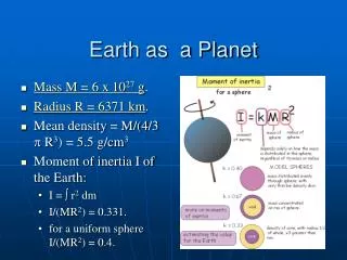
Crust • Igneous, Sedimentary & Metamorphic rock • Silicon, Iron, Magnesium, oxygen, aluminum, calcium, sodium, potassium • Solid • Ocean crust less than 10 km thick • Continental crust 32 to 70 Km thick
Mantle • Silicon, oxygen, iron, & magnesium • Liquid that shows plasticity • 870 to 2200 degrees Celsius • Radius = 2900 Km • About 70 Km below surface • 80% of Earth’s Volume & 68% of Earth’s Mass • Moho – 1909 Abdrija Mohorovicic • Above Mantle about 32 to 64 Km below surface of Earth
Inner Core Iron & nickel Solid 5000 degrees Celsius Radius = 1300 Km 5150 Km below surface Outer Core Around inner core Iron & nickel liquid 2200 to 5000 degrees Celsius Radius = 2250 Km 2900 Km below surface Earth’s Core
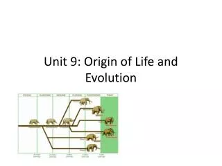
Plate Tectonics Pangaea Continental Drift – Alfred Wegener Evidence Fossils Continent shapes Rock formation on different continents Mineral and rock deposits (salt, limestone, glacial deposits) Coral reefs Swamps, oil deposits
Ocean-Floor Spreading Ocean crust younger than continent crust…? Ocean floor being subducted under continents Midocean ridges Rocks younger at center/ridges
Magnetic Stripes in Ocean-Floor • In molten rock magnetic minerals line up w/ the poles • Molten rock hardens leaving solid magnetic evidence • Scientists have discovered that the pole have switched over the past 3.5 million years because the magnetic stripes switch over
Magnetic stripes match on opposite sides of the mid-ocean ridge showing that both sides have changed at the same rate…giving more proof of sea floor spreading.
Convection Currents Movement of material due to a difference in temperature Lab & overhead…
Earth’s Moving Plates Theory of Plate tectonics links continental drift and ocean-floor spreading 7 major lithosphere plates and many smaller ones (pg 65 & overhead) Plates all move in different directions and at different speeds
Plate Boundaries • Divergent – constructive • Convergent – destructive • 2 ocean plates – older subducted • Ocean plate – continent – ocean plate is subducted and continental plate folds some • 2 continental plates – continents fold up into mts (appalachian, himalayan…) • Strike-slip – conservative
Divergent Boundaries Iceland
Plate Changes Plates fuse together Plates change direction New divergent boundaries form Plates can completely be subducted and disappear
New Ocean in Africa http://www.cbsnews.com/stories/2005/12/10/tech/main1115779.shtml
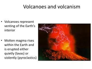
Volcanoes Formed when molten rock (magma) emerges through an opening, or vent, from Earth’s interior (above or below water) Lava = magma forced out of Earth’s interior Accumulation of volcanic lava and rock debris = a cone, dome shaped structure
Volcano Terms Crater = steep, funnel shaped depression at top of volcano Caldera = larger depression formed when crater collapses Cinder cone = tall, steep, explosive eruptions Shield volcano = large, gentle slope, quiet lava flows Composite volcano = alternate explosive eruptions & gentle lava flows
Volcanic Eruptions‘ • Gases – water vapor, carbon dioxide, hydrogen sulfide, chlorine, fluorine, boron • Liquids – lava • Solids – (pyroclastics – solid magma) ash bombs
Volcanic Activity • Active volcano – erupts continually or periodically • Dormant – currently not active, but known to have erupted in modern history • Extinct – not known to have erupted in modern history • Most activity occurs at plates boundaries • Ring of fire = circle around Pacific Ocean • Middle of Atlantic Ocean, and near Mediterranean Sea
Volcanic Geological Situations Two plates converge beneath an ocean, one plate goes beneath and melts = Aleutian Islands Mid-ocean ridge – two plates separate as molten material pushes up between Ocean plate moves beneath continent plate and melts = Cascade mts in Pacific NW
Hot spots Hawaiian Islands “hot spot” beneath crust push magma up creating volcanoes islands
Volcanic Impact Most people die from burns and/or suffocating Habitat destruction (human and wildlife) Natural resourse destruction Agricultural destruction Cleanup… Thermal energy, nitrogen….
On November 14, 1963, an Icelandic fisherman noticed a plume of smoke rising from the open water. Within a day, Surtsey, a new volcanic island, had formed off the southern coast of Iceland from an undersea eruption that originated at a 130 meter depth. An island eventually rose to a height of 169 metres above sea level that had an area of 2,5km². This island was named Surtsey for Surtur, the fire possessing giant of Norse mythology who would set fire to the earth at the Last Judgment.For three and a half years Surtsey rumbled and lava flowed. Long before the eruption stopped the island was proclaimed a nature preserve and all travel there was restricted to scientist that used this unique opportunity to study the gradual development of life on a sterile landmass.