Download
1 / 21
210 likes | 251 Views
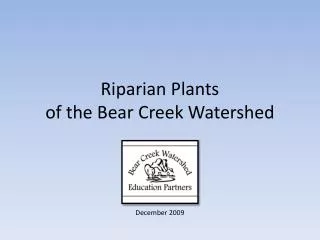
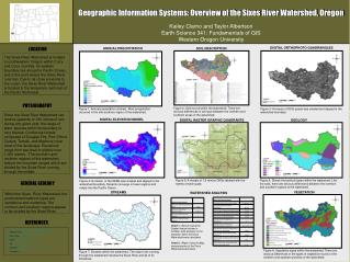
The Bear River Watershed Information System http://www.bearriverinfo.org. Jeffery S. Horsburgh Utah Water Research Laboratory Utah State University David Stevens, Nancy Mesner, Terry Glover, Arthur Caplan EPA Targeted Watersheds Grant Steering Committee.

E N D
The Bear River Watershed Information System http://www.bearriverinfo.org Jeffery S. Horsburgh Utah Water Research Laboratory Utah State University David Stevens, Nancy Mesner, Terry Glover, Arthur Caplan EPA Targeted Watersheds Grant Steering Committee
GOAL: Provide Unprecedented Access to Bear River Watershed Data and Information • WIS Components • Watershed-wide coordination web pages • A comprehensive data warehouse • A document warehouse • Data visualization and statistical tools
Watershed-Wide Coordination Watershed Descriptive Profileshttp://www.bearriverinfo.org/description/ • Based on USGS 8-Digit HUC Boundaries • Present Summaries of: • Elevation • Land Use/Land Cover • Major Tributaries and Water Bodies • Monitoring Locations • Populated Places • Land Ownership • Precipitation • Streamflow and Water Quality
Watershed-Wide Coordination People, Organizations, and ProjectsThe Resource Guidehttp://www.bearriverinfo.org/guide/ • Searchable index of experts, organizations, and projects related to water quality in the Bear River Basin • Users can submit experts, organizations, or projects
Watershed-Wide Coordination Online Calendar of Eventshttp://www.bearriverinfo.org/calendar/ • Searchable database of water quality related events • Events are linked to front page • Can view either calendar or list • Users can submit events
Watershed-Wide Coordination News Eventshttp://www.bearriverinfo.org/news/ • Searchable database of Bear River Related News Articles • News events are linked to front page • Users can submit news events
Document Warehouse/Digital Libraryhttp://www.bearriverinfo.org/library/ • Database of Bear River related documents, reports, maps, images, etc. • Users can submit digital objects • Linking to other external information sources
Comprehensive Data Warehouse GIS Datahttp://www.bearriverinfo.org/mapping/downloads.aspx • The WIS GIS database includes datasets in the following categories: • Administrative Boundaries • Environmental Monitoring Locations • Climate Monitoring Locations • Hydrology • Land Use/Land Cover • Geology • Terrain • Transportation • Watershed Boundaries
Comprehensive Data Warehouse Time Series Datahttp://water.usu.edu/analyst/ • An observations database has been designed and implemented for archiving environmental time series information for the Bear River Basin • The following datasets have been incorporated: • USGS published daily streamflow • USGS published water quality data • USGS groundwater data • STORET water quality data • NRCS SNOTEL Data • We will continue to incorporate new data as it becomes available
Real Time Monitoring Data • Integrate real time monitoring efforts in the Bear River basin • USGS • USU • PacifiCorp • Utah Water Rights • Others • Integrate as many as possible with the WIS • Link to others that already have a nice interface
Data Analysis and Visualization Toolshttp://www.bearriverinfo.org/tools/ • Internet Map Server • Time Series Analyst • Database Query Utility • TMDL Information Viewer
Data Analysis and Visualization Tools Internet Map Serverhttp://water.usu.edu/mapviewers/bearrivermap/ • Allows users to view GIS data • Many GIS features are linked to other datasets (i.e., time series data)
Data Analysis and Visualization Tools Time Series Analysthttp://water.usu.edu/analyst/ SQL Queries passed from Time Series Viewer to the server database Time Series Data Stored in Microsoft SQL Server Database Query results can be exported to a browser window or directly to Microsoft Excel User Interaction through Web Browser
Data Analysis and Visualization Tools TMDL Information Viewer http://water.usu.edu/mapviewers/BearRiverTMDL/ • Internet Map Server • TMDL Information Summary Application • Presents summary of TMDL Information for selected water body or point source
Data Analysis and Visualization Tools Database Query Utilityhttp://www.bearriverinfo.org/tools/query_utility/ • Allows users to query time series data out of the observations database • Criteria include • Station name • Station/data type • Parameter • Agency • Time Period • Export station information and data as text files
Advanced Observations Data Model Regardless of source, data must be accompanied by enough metadata so that they can be unambiguously interpreted and used.
Spatially Referenced Point and Click Data Access Linking the observational data with its spatial location provides users with: The ability to find the data that they want The ability to look at spatial relationships among sampling locations
Data Visualization and Summary Tools Simple data visualizations and summaries allow users to browse available data with very little effort.
The Road Ahead • Maintain a dynamic Watershed Information System • Incorporate new data as they become available • Enhance existing, and build new WIS tools • Work closely with the Trading and Modeling teams to incorporate their results
Project Partners USU Project Collaborators: Nancy Mesner Terry Glover David Stevens Arthur Caplan United States EPA Gary Kleeman Bear River Commission Jack Barnett Water Quality Task Force Mitch Poulson Wyoming DEQ Jack Smith Idaho DEQ Lynn Van Every Utah DEQ Mike Allred