Download
1 / 1
10 likes | 170 Views
A Survey of Wyoming King Air and Cloud Radar Observations in the Cumulus Photogrammetric In-Situ and Doppler Observations (CuPIDO) experiment

E N D
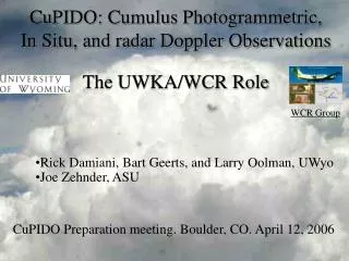
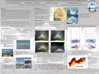
A Survey of Wyoming King Air and Cloud Radar Observations in the Cumulus Photogrammetric In-Situ and Doppler Observations (CuPIDO) experiment J. Cory Demko (coryuw@uwyo.edu) Rick Damiani (rickdami@uwyo.edu) Bart Geerts (geerts@uwyo.edu)Joseph Zehnder (zehnder@asu.edu) Department of Atmospheric Science, University of Wyoming Global Institute of Sustainability, Arizona State University Equivalent Potential Temperature (°K) Potential Temperature (°K) 1 2 Mixing Ratio (g/kg) Mixing Ratio (g/kg) 5 15 5 15 Equivalent Potential Temperature (°K) 4 345 3 N↑ Potential Temperature (°K) Equivalent Potential Temperature (°K) 330 Mixing Ratio (g/kg) 15 5 Site Location Rationale Santa Catalina Mountains, north of Tucson, AZ. This range has a maximum elevation of about 2800 m (9000 feet) and referred to as a “sky island” . 16 flights were conducted between 18 July and 17 August 2006. Cumulus convection is of fundamental importance as it serves as the primary mechanism for the vertical transfer of heat, moisture and momentum. Details of the evolution of cumulus convection at multiple scales, particularly the transition from shallow to deep convection, are important, since these processes must be parameterized in numerical weather prediction and general circulation models. CuPIDO examines fundamental cumulus dynamics and the two-way interaction between cumuli and the environment. The detrainment of momentum, heat and moisture by isolated cumuli is directly relevant to cumulus parameterization in NWP models An isolated mountain serves as a natural laboratory for the study of cumulus evolution, allowing continuous measurements by ground-based instruments, cameras, radiosondes, and aircraft. CuPIDO also aims to study how surface fluxes around an isolated mountain drives anabatic flow, moisture and heat convergence, and the initiation of shallow, mediocre, and deep convection. Successive shallow Cu developed between 1740 – 1840 UTC (~800m deep) evolving rapidly into congestus by 1935 UTC ISFF site Camera site Flight summary Number of flight hours: 60 Number of flights sampling transition from cloud-free to Cu congestus: ~8 Number of flights sampling transition to deep convection: ~7 Number of flight loops around the mountain, in the convective BL: Cumulus Dynamics using the Wyoming Cloud Radar (WCR) Scientific Objectives Orographic forcing of boundary layer flow: mass and moisture convergence • Characterize the onset and transition from shallow to deep convection using surface and upper air measurements, various ground-based profiling systems, in-situ and Doppler aircraft observations and stereo digital photogrammetric techniques. • CuPIDO will advance scientific knowledge on several fronts: • fundamental cumulus dynamics • orographic forcing of cumulus clouds • cumulus-environment interaction Who/What Was Involved? • University of Wyoming King Air Wyoming Cloud Radar • 18 July 2006 16:44:30 – 16:46:30 UTC (left) and 16:48:15 – 16:50:15 UTC (right)The figures show plumes detaching from the ground and connecting to clouds above. • Arizona State University Digital Visible Spectrum Cameras (2 stereopairs) • 25 July 2006 case illustrating orographic boundary layer forcing over the Santa Catalinas. Panels 1 – 3 illustrates circumnavigation loops at 1,000ft agl, 7,000ft msl, and 10,000ft msl conducted 1600 – 1647 UTC. Tracks show equivalent potential temperature and wind barbs are colored via mixing ratio. Panels 1 and 2 view the mountain top-down whereas panel 3 shows the southern periphery. Panel 4 illustrates an aircraft sounding from 1946 – 1953 UTC (23,000ft msl – 1,000ft agl). Track show equivalent potential temperature and wind barbs colored via potential temperature. Graphics produced using IDV. • Weak low - level upslope flow exists with very little if any wind shear. A relatively moist and cool boundary layer exists during the morning hours (MST) due to a Gulf of Mexico surge which arrived several hours prior. The boundary layer contained more moisture than any other day up to this point. Rather high CAPE, but also significant CIN existed during this IOP. • 18 July 2006 vertical plane dual Doppler image which shows a section of a turret tilting against the main wind direction. It is forming to the north of Mt. Lemmon. 18:03:30 – 18:04:20 UTC • NCAR/EOL 10 ISFF/PAM Stations 2 M-GAUS mobile radiosondes • University of Arizona: WRF modeling Support GPS water vapor