Download

1 / 30
300 likes | 432 Views
SSES Sensor Suite Evaluation System. Preliminary Solution Space Development. Helen Anderson, Steven Beres, Joseph Shaw, Timothy Valadez Thursday, 5 March 2009. 1. General Comments. Potential solutions fall into three general threads Strictly manual processes

E N D
SSESSensor Suite Evaluation System Preliminary Solution Space Development Helen Anderson, Steven Beres, Joseph Shaw, Timothy Valadez Thursday, 5 March 2009 Anderson, Beres, Shaw, Valadez 1
General Comments Anderson, Beres, Shaw, Valadez • Potential solutions fall into three general threads • Strictly manual processes • Model based processes including manual actions that are enabled / facilitated by a software development environment / tools / decision aids • Database / rule based / expert system processes • Significant overlap exists between threads • E.g. model based software application will likely include database / archiving functionality, all approaches will include involve a high degree of manual action • Functional decomposition may appear redundant in some areas due to separate consideration of modeling, analysis, and display functions • Done deliberately since implementation of these functions may be quite different
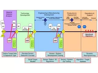
Design & Assess ESS SSES Functional Decomposition 1 Assess and represent site characteristics 3 Develop ESS designs and assess technical performance 4 Assess ESS operational performance 2 Assess and represent threat characteristics 3.2 Model emplaced single sensors 3.3 Model multi-sensor networks 2.1 Classify threats by type & attributes 4.1 Analyze operational performance 1.1 Get and use site attribute data 1.2 Construct site model 3.1 Represent single sensor performance 3.5 Optimize ESS designs 4.1.1 Route specific MOE 2.2 Manage signature data 3.3.1 Construct sensor networks 4.1.1.1 Min ingress / egress time 3.3.1.1 Manual selection 3.1.1 Maintain sensor database 2.2.1 Threat type & number 1.2.1 Construct terrain type map 1.2.1.1 Partition by terrain type 1.1.1 Get/display/ use terrain and feature data 3.3.1.2 Heuristic selection 3.1.2 Represent sensor Pd 2.2.2 EO/IR signature 4.1.1.2 Minimum Pd 1.1.1 Terrain types 3.1.3 Represent sensor range 2.2.3 Radar signature 3.3.1.3 Form networks 4.1.1.3 Minimum reaction time • 1.1.1.2 • Topographic data 1.2.2 Construct elevation model 2.2.4 RF signature 3.1.4 Represent false alarm rate 3.2.2 Place / orient sensors 3.3.2 Assess coverage, performance, cost 1.1.1.3 Feature data 2.2.5 Acoustic signature 1.2.3 Construct mobility model 3.1.5 Environ-mental effects 3.2.2.1 Manual selection 3.3.2.1 Sensor architectures 4.1.2.1 Perimeter Pd & Pinterdict 1.1.1.4 Elevation data 3.1.6 Represent sensor FOV 2.3 Support sensor models 1.2.3.1 Move rates and dwell times 3.2.2.2 Semi-auto selection 3.3.2.2 Apply sensor fusion 4.1.2.2 Worst case area Pd 3.1.7 Represent scan/revisit times 1.1.1.5 Imagery 3.2.3 Model sensor coverage and Pd 3.3.2.3 Determine point Pd 4.1.2.3 Worst case Pkeep-out 1.2.3.2 ID Ingress/egress routes 3.1.8 Support requirements 3.2.3.1 Model detection 3.3.2.4 Determine area Pd 3.1.9 Estimate single sensor cost 4.1.3 Display vulnerability 3.4 Estimate Sensor Network Cost 1.1.2 Get/display/use environment data 3.2.3.1.1 Calculate LOS 3.3.2.5 Determine network FAR 1.2.4 Manage site models & data 1.1.2.1 Weather 4.1.3.1 Max vulnerability routes 3.2.1 Select sensors 4.1.2 Assess vulnerability 3.2.3.1.2 Propagation loss 3.4.1 Installed + infrastructure costs 3.5.1 Manage designs and MOE/MOP 3.3.3 Show coverage, & performance 1.1.2.2 EM/RF interference 2.5 Represent threat objectives 2.4 Manage threat mobility data 4.1.3.2 Min response time routes 3.2.3.1.3 Field of view 3.2.1.1 Manual selection Level 3.3.3.1Point-to-point Pd 1.1.2.3 Traffic 3.5.2 Manually iterate designs 2.4.1 Speed over terrain 2.5.1 Intrusion objectives 3.2.3.1.4 Terrain type 3.2.1.2 Semi-auto selection 4.1.3.3 Cumulative Pd coverage 0 3.3.3.2 Area Pd 3.5.3 Heuristically iterate designs 1.1.2.4 Manage environ. data 1 3.2.3.1.5 Environment 2.5.2 Covertness posture 2.4.2 Prohib-ited terrain 3.2.1.3 Auto-matic selection 4.2 Estimate ESS total cost 2 3.3.3.3 Coverage by sensor type 3.2.3.1.6 Pd at discrete points 2.5.3 Survivability objectives 2.4.3 Barriers & obstacles 3 4.2.1 Procure, install, operate cost 3.3.3.4 Gaps and blind spots 3.2.3.1.7 Area aggregate Pd 4 Anderson, Beres, Shaw, Valadez 5 3.3.3.5 False alarm rate 2.6 Support route planning models 3.2.3.1.8 False alarm rate
SSES Function - Form Alternatives 1.1.1 FUNCTIONS ALTERNATIVE FORMS 1. Represent and assess site characteristics 1.1 Obtain, display, and use site attributes and characteristics data 1.1.1 Obtain, display, and manipulate topographic, characteristic, and feature data 1.1.1.1 Classify terrain based on physical characteristics that may affect sensor performance, and threat mobility and detectability • Direct specification of individual terrain characteristics • Indexed terrain data with exemplars • Hybrid - indexed with editable characteristics 1.1.1.2 Obtain, display, and manipulate topographic, characteristic, and feature data • Obtain • Manual data entry / editing • Software enabled maual capture of image / map data • Automated pattern/feature recognition of image data • Direct interface with GIS databases and image archives • Display / manipulate: • Paper maps with overlays • Hard copy tabular data • Software generated maps and displays • Interactive GUI development environment 1.1.1.3 Obtain and represent data on discrete site features and objects that may affect sensor performance or threat mobility • Patch and facet / wire frame models • Coordinate geometry models • Data base position/shape entry 1.1.1.4 Obtain, display, and manipulate site elevation data from external sources • Software import of DTED data from file / CD • Software import of other DEM data from file / CD • Direct interface with GIS systems • Automated interpolation of map/image contours • Manual parsing and entry of elevation data 1.1.1.5 Obtain, display, and utilize site imagery data • File of hardcopy imagery • Image database with display tools Anderson, Beres, Shaw, Valadez
SSES Function - Form Alternatives 1.1.2 FUNCTIONS ALTERNATIVE FORMS 1. Represent and assess site characteristics 1.1 Obtain, display, and use site attributes and characteristics data 1.1.2 Represent environmental characteristics and assess environmental effects on ESS sensor and network performance 1.1.2.1 Represent weather including temperature, precipitation, airborne particulates, and winds • Direct specification of environment parameters • Indexed environment data with standard environments • Hybrid - indexed with editable parameters 1.1.2.2 Represent electromagnetic and radio-frequency interference that may interfere with sensors and wireless networks • Direct specification of traffic density by type • Indexed traffic density with standard densities 1.1.2.3 Represent personnel, vehicular, and animal traffic that may trigger sensors • Direct specification of traffic density by type • Indexed traffic density with standard densities 1.1.2.4 Maintain a list/database of environmental conditions / factors • Software model environment database • Electronic environment database • Hard copy tabular environment data Anderson, Beres, Shaw, Valadez
SSES Function - Form Alternatives 1.2.1 FUNCTIONS ALTERNATIVE FORMS 1. Represent and assess site characteristics 1.2 Construct, display, and manipulate site models / analytic representations 1.2.1 Construct, display, and manipulate site terrain characteristics models • Software models with GUI • Database model with query tools • Hard copy tabular data Software terrain model • Terrain database • Hard copy map with terrain shading 1.2.1.1 Partition site into regions with homogeneous terrain characteristics • Automated partitioning of terrain map/image data • Automated partitioning of terrain database data • Software enabled manual partitioning of terrain map/image data with direct data entry • Manual partitioning of terrain map/image data with manual data entry Anderson, Beres, Shaw, Valadez
SSES Function - Form Alternatives 1.2.2 FUNCTIONS ALTERNATIVE FORMS 1. Represent and assess site characteristics 1.2 Construct, display, and manipulate site models / analytic representations 1.2.2 Construct, display, and manipulate site terrain elevation models • Terrain elevation data grid model with editor • Terrain elevation data patch model with editor • Terrain elevation database with query tools • Hardcopy terrain elevation map • Physical relief map / model Anderson, Beres, Shaw, Valadez
SSES Function - Form Alternatives 1.2.3 FUNCTIONS ALTERNATIVE FORMS 1. Represent and assess site characteristics 1.2 Construct, display, and manipulate site models / analytic representations 1.2.3 Construct, display, and manipulate threat dependent trafficability models • Representation • Densely connected point-to-point network model • Sparsely connected point-to-point network model • Point-to-point movement database • Hard copy map with mensuration tools • Network model with edge rates/costs • Map tessellation with face movement rates/costs 1.2.3.1 Estimate threat movement rates and expected dwell times • Automated calculation of point-to-point distances and rates using model data • Automated calculation of point-to-point distances and rates using database data • Direct interface with GIS system • Manual calculation and entry of distances and rates • Software enabled editing of movement rates/costs 1.2.3.2 Identify feasible ingress and egress routes • Network representation with shortest path algorithms • Database look-up • Tabular data look-up Anderson, Beres, Shaw, Valadez
SSES Function - Form Alternatives 1.2.4 FUNCTIONS ALTERNATIVE FORMS 1. Represent and assess site characteristics 1.2 Construct, display, and manipulate site models / analytic representations 1.2.4 Save, recall, and manage site terrain models and data • Embedded model archive • Internal database • Off-line database Anderson, Beres, Shaw, Valadez
SSES Function - Form Alternatives 2.1 FUNCTIONS ALTERNATIVE FORMS 2. Assess and represent projected / potential threat characteristics 2.1 Classify threats based on their type and attributes • Manual threat classification • Intel / threat database • Explicitly model threat characteristics without classification Anderson, Beres, Shaw, Valadez
SSES Function - Form Alternatives 2.2.1 FUNCTIONS ALTERNATIVE FORMS 2. Assess and represent projected / potential threat characteristics 2.2 Obtain and manage threat classification and quantitative threat signature data 2.2.1. Represent threat types (e.g. personnel, wheeled vehicles, tracked vehicles, watercraft) and numbers • Software entity models • Threat data base entries • Physical "toy soldier" models 2.2.2 Represent threat physical dimensions and visual / infra-red (IR) characteristics • Explicit modeling of signatures and characteristics • Database entry for signatures and characteristics • Implicitly represent in sensor-threat performance data 2.2.3 Represent threat radar cross section (RCS) • Explicit modeling of signatures and characteristics • Database entry for signatures and characteristics • Implicitly represent in sensor-threat performance data 2.2.4 Represent threat radio-frequency (RF) emissions • Explicit modeling of signatures and characteristics • Database entry for signatures and characteristics • Implicitly represent in sensor-threat performance data 2.2.5 Represent threat acoustic and seismic emissions including signature dependency on threat speed • Explicit modeling of signatures and characteristics • Database entry for signatures and characteristics • Implicitly represent in sensor-threat performance data Anderson, Beres, Shaw, Valadez
SSES Function - Form Alternatives 2.3 FUNCTIONS ALTERNATIVE FORMS 2. Assess and represent projected / potential threat characteristics 2.3 Provide threat class and signature data to sensor performance models • Integrated sensor performance model interface • Sensor performance model database query tools • Manual entry and calculation of sensor performance Anderson, Beres, Shaw, Valadez
SSES Function - Form Alternatives 2.4 FUNCTIONS ALTERNATIVE FORMS 2. Assess and represent projected / potential threat characteristics 2.4 Obtain and manage threat mobility data 2.4.1 Represent threat speed as a function of the type of terrain being traversed • Software terrain dependent threat mobility model • Terrain dependent threat movement rate look-up tables • Manual calculation of movement rates 2.4.2 Represent prohibited terrain types which may not be traversed by specific classes / types of threat • Specify prohibitive threat / terrain dependent mobility network edge costs • Specify prohibitive threat / terrain dependent database movement costs • Maintain threat-terrain tabu list 2.4.3 Represent mobility effects of barriers and obstacles • Direct specification of traffic density by type • Indexed traffic density with standard densities Anderson, Beres, Shaw, Valadez
SSES Function - Form Alternatives 2.5 FUNCTIONS ALTERNATIVE FORMS 2. Assess and represent projected / potential threat characteristics 2.5 Represent threat objectives, behaviors and operating constraints 2.5.1 Represent threat intrusion objectives • Manually specify threat movement paths • Specify objectives as sink nodes for network flow / shortest path algorithms 2.5.2 Represent threat covertness posture • Include behaviors as part of threat characterization • Dynamically modify signatures and characteristics based on behavior 2.5.3 Represent threat survivability / escape objectives • Manually specify threat movement paths • Specify both objectives and egress points as sink nodes for two part network flow / shortest path algorithms • Specify tabu points / regions based on actual or perceived detection probabilities • Maintain threat-terrain tabu list Anderson, Beres, Shaw, Valadez
SSES Function - Form Alternatives 2.6 FUNCTIONS ALTERNATIVE FORMS 2. Assess and represent projected / potential threat characteristics 2.6 Provide mobility and behavior data to threat route planning, and performance assessment functions • Integrated design environment with direct interfaces • Manual data import / export • Perform via database query Anderson, Beres, Shaw, Valadez
SSES Function - Form Alternatives 3.1 FUNCTIONS ALTERNATIVE FORMS 3 Develop ESS designs and assess technical performance 3.1 Obtain, display, and manage attribute and performance data on for individual sensor system elements 3.1.1 Maintain a list/data base of available sensors • Manual entry and database management of sensor specifications and performance • Software supported import of sensor specifications and performance data • Web based query of vendor sensor specs & performance 3.1.2 Model/represent sensor nominal Pd as a function of threat type/signature and terrain type • Physics / engineering based sensor performance model • Sensor performance database • Hardcopy sensor performance tabular data 3.1.3 Model/represent sensor nominal effective range as a function of threat type/signature and terrain type • Physics / engineering based sensor performance model • Sensor performance database • Hardcopy sensor performance tabular data 3.1.4 Model/represent sensor nominal false alarm rate • Physics / engineering based sensor performance model • Sensor performance database • Hardcopy sensor performance tabular data 3.1.5 Model/represent sensor susceptibility to environmental effects and the effect of environment on Pd, effective range and FAR • Incorporate directly into physics / engineering based sensor performance model • Incorporate directly into sensor performance database values / tabular data • Apply environment dependent correction factor to performance determined by model / database lookup 3.1.6 Model/represent sensor field-of-view (azimuth and elevation limits) • Represent explicitly • Incorporate into Pd performance data Anderson, Beres, Shaw, Valadez Continued on next slide
SSES Function - Form Alternatives 3.1 (cont) FUNCTIONS ALTERNATIVE FORMS 3 Develop ESS designs and assess technical performance 3.1 Obtain, display, and manage attribute and performance data on for individual sensor system elements 3.1.7 Model/represent sensor scan / revisit times • Represent explicitly • Incorporate into Pd models / performance data 3.1.8 Represent sensor support requirements including electrical power, communications / connectivity mechanisms, and interfaces • Electronic sensor support requirement database • Hardcopy sensor support requirement tabular data 3.1.9 Represent sensor cost data including procurement, installation, and life-cycle operations and support costs • Electronic sensor cost database • Hardcopy sensor cost tabular data Anderson, Beres, Shaw, Valadez
SSES Function - Form Alternatives 3.2.1 FUNCTIONS ALTERNATIVE FORMS 3 Develop ESS designs and assess technical performance 3.2 Select, place, assess, and display the performance of individual sensors 3.2.1 Select sensors from list of available sensors 3.2.1.1 Manually select sensors • Manually select from pull down menu in development environment • Manually select by drag-and-drop in development environment • Manually select via database query 3.2.1.2 Recommend sensors for manual selection • Same as 3.2.1.1. above, but with manual acceptance and editing 3.2.1.3 Automatically select sensors • Rule based expert system • Greedy set covering algorithms • Network flow / spanning tree algorithms • Dynamic programming algorithm • Stochastic design using genetic algorithms or simulated annealing Anderson, Beres, Shaw, Valadez
SSES Function - Form Alternatives 3.2.2 FUNCTIONS ALTERNATIVE FORMS 3 Develop ESS designs and assess technical performance 3.2 Select, place, assess, and display the performance of individual sensors 3.2.2 Position and orient sensors 3.2.2.1 Manually position and orient sensors • Manually edit sensor position / orientation in development environment • Drag sensor position / orientation in development environment • Manually edit sensor position / orientation in database 3.2.2.2 Recommend sensors for manual selection • Integrated into 3.2.1.3 functionality Anderson, Beres, Shaw, Valadez
SSES Function - Form Alternatives 3.2.3.1 FUNCTIONS ALTERNATIVE FORMS 3 Develop ESS designs and assess technical performance 3.2 Select, place, assess, and display the performance of individual sensors 3.2.3 Assess and display sensor coverage and detection performance 3.2.3.1 Model emplaced sensor detection performance • Physics / engineering based sensor performance model • Sensor performance database • Hardcopy sensor performance tabular data 3.2.3.1.1 Calculate sensor-to-target LOS • Automatic LOS calculation based on terrain elevation grid & feature data • Automatic LOS calculation based on terrain facet & feature data • Database LOS 3.2.3.1.2 Determine target-to-sensor propagation path losses • Automatic propagation path / path loss calculation based on terrain model / database • Database path/path loss look-up (source of database path/path loss data unclear) • Manual calculation and entry of path losses 3.2.3.1.3 Determine sensor azimuth and elevation coverage • Incorporate azimuth and elevation and field-of-view limits directly into physics / engineering based sensor performance model • Incorporate azimuth and elevation and field-of-view limits into sensor 3.2.3.1.4 Calculate terrain type effects on sensor performance • Incorporate terrain type directly into physics / engineering based sensor performance model • Incorporate terrain type into sensor performance database values / tabular data • Apply terrain dependent correction factor to performance determined by model / database lookup Anderson, Beres, Shaw, Valadez Continued on next slide
SSES Function - Form Alternatives 3.2.3.1 (cont) FUNCTIONS ALTERNATIVE FORMS 3 Develop ESS designs and assess technical performance 3.2 Select, place, assess, and display the performance of individual sensors 3.2.3 Assess and display sensor coverage and detection performance 3.2.3.1 Model emplaced sensor detection performance 3.2.3.1.5 Adjust sensor performance for environmental effects • Incorporate environmental factors directly into physics / engineering based sensor performance model • Incorporate environment into sensor performance database values / tabular data • Apply environment dependent correction factor to performance determined by model / database lookup 3.2.3.1.6 Calculate Pd at discrete points as a function of sensor, threat, terrain, and environmental conditions • Perform on-demand physics / engineering based Pd modeling • Pre-calculate point-to-point Pd values and populate database (ultimate data source / methodology unclear) • Manually calculate Pd performance 3.2.3.1.7 Calculate aggregate Pd for designated areas as a function of sensor, threat, terrain, and environmental conditions • Pre-calculate area aggregate Pd values and populate database (data source unclear) • Manually calculate aggregate area Pd performance • Sample Pd data over a grid and aggregate results • Stochastically sample Pd data at random points and compute expected values 3.2.3.1.8 Calculate sensor internally and externally generated false alarm rates • Physics / engineering based sensor false alarm model • Sensor false alarm database • Hardcopy sensor false alarm tabular data Anderson, Beres, Shaw, Valadez
SSES Function - Form Alternatives 3.3.1 FUNCTIONS ALTERNATIVE FORMS 3 Develop ESS designs and assess technical performance 3.3 Construct, assess, and display the performance and cost of sensor suites 3.3.1 Construct sensor networks from individual sensors 3.3.1.1 Manually select and position sets of sensors • Direct manual selection and placement • Manual selection and placement by rule • Manually select sensor type, with auto placement 3.3.1.2 Heuristically select and position sets of sensors • Heuristic fill-in of manually seeded sensors • Spanning tree / network flow algorithms • Dynamic programming algorithms 3.3.1.3 Form sensor networks • Manually connect • Shortest path / spanning tree algorithms • Bayesnet algorithms • Colored Petri Net algorithms Anderson, Beres, Shaw, Valadez
SSES Function - Form Alternatives 3.3.2 FUNCTIONS ALTERNATIVE FORMS 3 Develop ESS designs and assess technical performance 3.3 Construct, assess, and display the performance and cost of sensor suites 3.3.2 , Assess sensor suite coverage, detection performance and cost 3.3.2.1 Represent the integration of the outputs of multiple sensors in various architectures • Signal flow diagram 3.3.2.2 Apply alternative sensor fusion rules • Voting algorithms • Primary sensor with confirmation • Bayesian classification algorithms • Colored petri-net 3.3.2.3 Determine sensor suite fused Pd for discrete points as a function of sensor, threat, terrain, and environment • Done via application of algorithms in 3.3.2.2 to specific sensor-target geometries 3.3.2.4 Determine sensor suite aggregate fused Pd for designated areas as a function of sensor, threat, terrain, and environment • Represent area Pd by centroid point-to-point Pd • Aggregate point-to-point results over regular grid • Use expected value of Monte Carlo point-to-point results 3.3.2.5 Determine fused false alarm rate for the sensor suite for alternative sensor fusion rules • Incorporate into 3.3.2.2 algorithms Anderson, Beres, Shaw, Valadez
SSES Function - Form Alternatives 3.3.3 FUNCTIONS ALTERNATIVE FORMS 3 Develop ESS designs and assess technical performance 3.3 Construct, assess, and display the performance and cost of sensor suites 3.3.3 Display sensor suite coverage and detection performance 3.3.3.1 Display sensor suite Pd for specific points • Interactive multi-sensor Pd display in development environment • Multi-sensor Pd database query tools • Manual calculation and display of multi-sensor Pd 3.3.3.2 Display sensor suite Pd for designated areas • Color coded Pd map overlays in development environment • Database query Pd numeric data • Database query Pd plot data • Multi-layer manual map overlays 3.3.3.3 Display sensor coverage by sensor and type • Color coded sensor coverage map overlays in development environment • Database query sensor coverage numeric data • Database query sensor coverage plot data • Multi-layer manual map overlays 3.3.3.4 Display sensor coverage gaps and blind spots • Same as 3.3.3.3 3.3.3.5 Display sensor suite false alarm rate • Sensor false alarm numeric data • Sensor false alarm frequency plots / histograms Anderson, Beres, Shaw, Valadez
SSES Function - Form Alternatives 3.3.1 FUNCTIONS ALTERNATIVE FORMS 3 Develop ESS designs and assess technical performance 3.4 Construct, assess, and display the performance and cost of sensor suites 3.4.1 Estimate cost • Integrated cost estimation tool in development environment • Integrated cost estimation tool in database • Automatically populated cost estimation spreadsheet • Manually populated cost estimation spreadsheet • Manual cost estimation from tabular / catalogue data Anderson, Beres, Shaw, Valadez
Preliminary SSES Functional Decomposition FUNCTIONS ALTERNATIVE FORMS 3 Develop ESS designs and assess technical performance 3.5 Optimize ESS designs • Embedded database • Off-line database • Manual tabulation and management of data 3.5.1 Store, recall, and manage ESS designs and associated performance metrics 3.5.2 Manually perform, ESS design iterations, and compare results • Manual design and assessment with integrated comparison tools in development environment • Manual design and assessment with integrated comparison tools in database • Manual design and assessment with off-line comparison of designs 3.5.3 Heuristically ally perform, ESS design iterations, and compare results • Automatic implementation of manually developed heuristics • Dynamic programming algorithms • Greedy set covering • Simulated annealing • Genetic algorithms Anderson, Beres, Shaw, Valadez
Preliminary SSES Functional Decomposition FUNCTIONS ALTERNATIVE FORMS 4 Assess ESS operational performance 4.1 Assess and display ESS operational performance against customer site protection requirements using analytic methods 4.1.1 Calculate measures of effectiveness for threat ingress/egress routes 4.1.1.1 Identify intruder ingress / egress route(s) that minimize the time required to reach defended areas • Solve movement rate weighted shortest path / network flow problem all or designated nodes 4.1.1.2 Identify intruder ingress / egress route(s) that minimize the probability of being detected • Solve Pd weighted shortest path / network flow problem for all or designated nodes 4.1.1.3 Identify intruder ingress / egress route(s) that minimize Pd weighted security force reaction times • Solve interdiction probability weighted shortest path / network flow problem all or designated nodes Anderson, Beres, Shaw, Valadez
Preliminary SSES Functional Decomposition FUNCTIONS ALTERNATIVE FORMS 4 Assess ESS operational performance 4.1 Assess and display ESS operational performance against customer site protection requirements using analytic methods 4.1.2 Calculate measures of effectiveness for maximum vulnerability threat routes 4.1.2.1 Calculate mean and minimum site perimeter detection and interdiction probabilities • Find minimum Pd and interdiction probabilities around perimeter network cycles 4.1.2.2 Calculate worst case cumulative Pd for designated areas • Find minimum path values from 4.1.1.2 4.1.2.3 Calculate worst case cumulative interdiction keep-out probabilities for designated areas • Find minimum path values from 4.1.1.3 Anderson, Beres, Shaw, Valadez
Preliminary SSES Functional Decomposition FUNCTIONS ALTERNATIVE FORMS 4 Assess ESS operational performance 4.1 Assess and display ESS operational performance against customer site protection requirements using analytic methods 4.1.3 Display site protection measures of effectiveness 4.1.3.1 Display minimum Pd threat ingress / egress routes • Find minimum Pd and interdiction probabilities around perimeter network cycles 4.1.3.2 Display minimum response time threat ingress / egress routes • Minimum path value from 4.1.1.2 4.1.3.3 Display site sensor cumulative detection probability coverage maps • Minimum path value from 4.1.1.3 Anderson, Beres, Shaw, Valadez
Preliminary SSES Functional Decomposition FUNCTIONS ALTERNATIVE FORMS 4 Assess ESS operational performance 4.2 Assess ESS total cost 4.2.1 Estimate ESS total ownership costs taking into account all procurement, installation, facilities and operating costs • Integrated total cost estimation tool in development environment • Integrated total cost estimation tool in database • Automatically populated total cost estimation spreadsheet • Manually populated total cost estimation spreadsheet • Manual total cost estimation from tabular / catalogue data Anderson, Beres, Shaw, Valadez