Download
1 / 53
530 likes | 545 Views
Explore Earth's hydrologic cycle, isotopes, precipitation, rivers, floods, and water resources through lectures and quizzes. Understand Hadley cells, climate zones, and water origins. Sketch atmospheric circulation cells and identify climate zones.

E N D
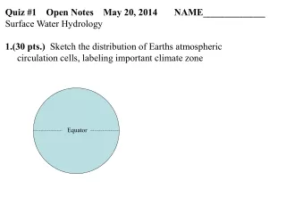
Quiz #1 Open Notes May 20, 2014 NAME_____________ • Surface Water Hydrology • (30 pts.) Sketch the distribution of Earths atmospheric • circulation cells, labeling important climate zone Equator
(30 pts.) What are the probable origins (or water type) of the following waters with the indicated characteristics? Suggest a location and occurrence (e.g., London rain) where each sample might have been found. All of these are real samples.
Surface Water Hydrology Bob Criss Apollo 17 12/7/72
Major Topics: Hydrologic Cycle & Reservoirs Isotope Hydrology Precipitation, Runoff, Evapotranspiration Alluvial Systems Darcy’s Law Flash Floods, Rainfall-Runoff Modeling Great Rivers, River Structures and Regional Floods Flood Recurrence & Risk => Hydrologic Data, Records, Data-based Theoretical Models
Major Topics: Hydrologic Cycle & Reservoirs Isotope Hydrology Precipitation, Runoff, Evapotranspiration Alluvial Systems Darcy’s Law Flash Floods, Rainfall-Runoff Modeling Great Rivers, River Structures and Regional Floods Flood Recurrence & Risk => Hydrologic Data, Records, Data-based Theoretical Models 8 Lectures, 8 quizzes
HYDROSPHERE 1.36 x 10⁹ km3 = 1.36 x 10²¹ liters Seawater 97.2 % 3.5 wt % salt; very homogeneous covers 70% of the surface, mean depth 3.8 km Icecaps & Glaciers 2.15 % >75% of fresh water Pleistocene oscillations ±100 m Groundwater 0.62 % 22% of all fresh water Lakes, inland seas 0.017% Atmosphere 0.001% Stream Channels 0.0001% USGS
Renewablevs.Non-renewable Renewable resources Resources that are replenished on short time scales. e.g., plants, animals, running water, solar energy. Non-renewable resources Resources that are fixed in total quantity in the Earth's crust. Not replenished on short time scales. Streamflow = Runoff (Ro) Arguably a resource Reason: Groundwater = Largest volume of accessible fresh water Arguably a resource Reason:
Renewablevs.Non-renewable Renewable resources Resources that are replenished on short time scales. e.g., plants, animals, running water, solar energy. Non-renewable resources Resources that are fixed in total quantity in the Earth's crust. Not replenished on short time scales. Streamflow = Runoff (Ro) Arguably a renewable resource Reason: continuously replenished Groundwater = Largest volume of accessible fresh water Arguably a non-renewable resource Reason: Slow recharge in most areas wrt rate of use
Renewablevs.Non-renewable Renewable resources Resources that are replenished on short time scales. e.g., plants, animals, running water, solar energy. Non-renewable resources Resources that are fixed in total quantity in the Earth's crust. Not replenished on short time scales. Streamflow = Runoff (Ro) Arguably a renewable resource Reason: continuously replenished Exception: can be degraded in quality Groundwater = Largest volume of accessible fresh water Arguably a non-renewable resource Reason: Slow recharge in most areas wrt rate of use
GENERAL CIRCULATION Hadley cellsGeorge Hadley (1735) Large scale, flat circulation cells Explain Trade Winds Control pressure & wind patterns, rainfall Venus Slow retrograde rotation = 243 days Equator to pole Hadley cell
Polar High Pressure Equatorial Low Pressure Equatorial Low Pressure Polar High Pressure Hadley Circulation Non tilted, Non-rotating planet after Marsh 1967
Venus in UV Pioneer 1980 NASA
3-Cell Hadley Model after Miller, A 1983
Cold Hyperarid Arid Semiarid Humid WRI 2002
Earth 24 h rotation rate- Hadley cells break up into smaller cells (Ferrel 1856) Hadley Cells Ferrel Cells Polar Cells Distinctive Climatic Zones ITCZ : Intertropical Convergence Zone Equatorial belt of low pressures Not really a front Constant, wet, aseasonal climate Rising air, year round high rainfall Winds cancel, calm (doldrums), no hurricanes Trade Wind Belt High Pressure Belts: (~ 30° N & S lat) Westerlies Polar Front (~60° N & S)
Earth 24 h rotation rate- Hadley cells break up into smaller cells (Ferrel 1856) Hadley Cells Ferrel Cells Polar Cells Distinctive Climatic Zones ITCZ : Intertropical Convergence Zone Equatorial belt of low pressures Not really a front Constant, wet, aseasonal climate Rising air, year round high rainfall Winds cancel, calm (doldrums), no hurricanes Trade Wind Belt Brisk, steady winds High Pressure Belts: (~ 30° N & S lat) Horse Latitudes Descending air, hot & dry due to adiabatic compression Divergence of trade winds & westerlies General anticyclonic rotation Westerlies Polar Front (~60° N & S) Convergence of air masses having different T; Permanent front Low pressures, ascending air, Jet stream position
Isotope Hydrology Bob Criss Washington University
Z Moody et al. (2005) N
Most elements below Bi (#83) have at least two stable nuclides Exceptions: 9Be 19F 23Na 27Al 31P 45Sc … http://wwwndc.tokai.jaeri.go.jp/CN03/CN001.html
H 1.0079 HYDROGEN ISOTOPES Protium 1H 1.00782503 99.985 at. % Deuterium 2H 2.01410178 0.015 at. % Tritium 3H 3.01605 12.32 yr
O 15.9994 OXYGEN ISOTOPES Oxygen-16 16O 15.99491462 99.76 at. % Oxygen-17 17O 16.9991314 0.04 at. % Oxygen-18 18O 17.999160 0.200 at. % 8p+8n 8p+9n 8p+10n
ISOTOPE HYDROLOGY NATURAL WATERS 18O, D, T Ideal, double isotopic tracer system Conservativetracers Intrinsic to the H2O molecule dD vs. d18O plot
Delta Values Abundance variations of stable nonradiogenic isotopes are normally small. A difference technique (formerly, voltage divider) is used to compare the mass spectrometer beam intensities with those of a standard gas. It is natural and best to report the isotopic constitution of a sample (x) in terms of its dimensionless difference from a known standard (std). Define thed-value("delta-value"): where R's are isotope ratios 1000x converts the d-values to per mil ‰ Some workers use 100x and % for D/H
Isotope Hydrology OCEAN: 97.2 % of hydrosphere Mean depth ~ 3.8 km Volume = 1.37 x 10⁹ km3 SEAWATER: Very uniform, buffered Salinity 35‰ d18O = 0 ± 1 ‰ dD = 0 ± 5 ‰ Isotopic variations coupled with salinity variations E/P, sea ice Melt icecaps: d18O = -1 Meteoric Water: huge range d18O = +4 to -62 ‰ dD = +40 to -500 ‰
E-W transect @ ~20°N Craig & Gordon 1965
METEORIC WATER Water that originates as precipitation in the hydrologic cycle Large isotopic variations: Values lowest in cold, high latitude, interior regions Approx Range: d18O = +4 to -62 ‰ dD = +40 to -500 ‰ e.g., SLAP (-55.5 , -428)
Water Types: METEORIC WATER: Originates as precipitation w/i hydrologic cycle Large variations: d18O = +4 to -62 dD = +40 to -500 Meteoric Water Line (MWL) dD = 8 d18O + 10 Slope: equilibrium effect y-intercept:kinetic effect “Deuterium excess” = dD - 8 d18O Some Local Variation Different water lines Intercept can be higher in low humidity regions, e.g., +22 for Mediterranean
SMOW dD MWL dD = 8 d18O + 10 d18O Craig 1961
Spatial and Temporal Variability SMOW dD MWL dD = 8 d18O + 10 d18O Craig 1961
d18O values of Meteoric Waters modified after Taylor 1974
Applications of Isotopic “Fingerprinting” Water Source Identification Flowpath Delineation Spring Tracing Groundwater Tracing Contaminant Plume Visualization Groundwater Velocity Determination Process Deduction Evolved Waters Forensics Mixing Studies Hydrograph Separation River Mixing Surface Water-Ground Water Interaction Constituent or Contaminant Sourcing
3-Cell Hadley Model after Miller, A 1983
Global Mean E and P E P McIntosh & Thom Humidity
Global Precipitation http://precip.gsfc.nasa.gov/gifs/v2.79-06.climo.gif