Download
1 / 24
250 likes | 586 Views
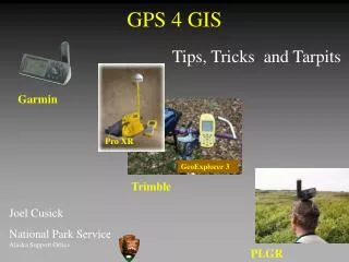
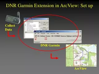
Collect Data. DNR Garmin. ArcView. DNR Garmin Extension in ArcView: Set up . For best results, the Garmin GPS should be connected to the computer via a serial cable and turned on before loading the DNR Garmin extension. . Getting Connected - Check. Turn on Garmin GPS.

E N D
Collect Data DNR Garmin ArcView DNR Garmin Extension in ArcView: Set up
For best results, the Garmin GPS should be connected to the computer via a serial cable and turned on before loading the DNR Garmin extension. Getting Connected - Check • Turn on Garmin GPS
Getting Connected - Check • Close VB Program if Open (DNRGarmin operating outside of ArcView)
Start ArcView • Start Button| Programs | ESRI | ArcView3 | ArcView Getting Connected - Step 1 • Open an ArcView • New View Or... • “with a new View” when dialog box inquires
Set View | Properties • Map Units: meters • Distance Units: feet • Load DNR Garmin Extension • Select File | Extensions... • Scroll to Select “DNR Garmin - ArcView” • Press OK Getting Connected - Step 1
Set Projection • Since some of you may already have loaded DNR Garmin, we need to ensure the Projection is set • Select DNR Garmin | Set Projection • This may not be the correct projection and datum, Press NO • Set parameters to the Class Instructions Getting Connected - Step 2
Projections - What’s the big deal anyway! • To GIS personnel - this is a big deal • Intimately linked to the data collection from the field • Ask how the GIS personnel prefers the data • All raw GPS data is expressed in Lat/Long Decimal Degrees - WGS84 Datum • Setting Garmin to Garmin Protocol ensures data arriving in downloaded as DD WGS84
Projections - What’s the big deal anyway! • When GPS data is downloaded to ArcView the data is projected “on the fly” using the projection you define using: • DNRGarmin | Set Projection Dialog box • Information is stored in a file and can be reset at any time • This assumes the base data is projected and is being displayed in an unprojected View.
Download Waypoints into ArcView • Select Waypoint | Download
Review! Table Edit Techniques • Edit Waypoint Data • Delete 2nd Archeological Site (Remove Row two) • Highlight row • Click to delete selected row • Delete extraneous column data • Click to delete selected columns
Shapefile will be added to View • Turn on in View Save as ArcView Shapefile • Select File | Save To | ArcView | Shapefile • Rename and Save Shapefile
Download Track into ArcView • Select Tracks | Download What’s with the blue? This is an indication of a “new” track. This signifies a break in sequence of track point data collection based on date and/or time.
Review! Download Track into ArcView • Delete Track Data • Delete extraneous columns • Highlight column • Click to delete selected columns
Review! Save as ArcView Shapefile • Select File | Save To | ArcView | Shapefile • Output Point • Rename and Save Shapefile • Shapefile will be added to Themes • Turn on in View
Track Management • Exit the DNR Garmin Extension • File | Exit
Edit Point Shapefile • Turn on Track Point Shapefile (turn off others) • Make Point Theme Active (raised) • Use Select tool and select points that make up the “polygon”
Edit Point Shapefile • In the DNR Garmin drop down menu choose: DNR Garmin | Convert Points • Convert Points window pops open Selected Selected Points in Yellow in Yellow
Edit Point Shapefile • Order Field | Time • Conversion Type | To Polygon • Output | As Shapefile Result: Polygon created from selected points
Edit | Delete Themes • Yes or Yes to All Deleting a Theme in the View • Delete Track Point Theme from View • Select theme (make active) to delete • Hold shift key to select more than one theme (for future reference)
Review! Add Themes to the View • Add Theme Button or View | Add Theme • Change Data Source Type to Feature or Image Data Source • Select more than one file by holding the shift key down
Double click on Point theme • Double click on symbol to Edit • Click on Paint Brush • Change color • Apply Edit Legend: Point Theme • Change point size
Double click on theme in legend • Double click on symbol to Edit • Use the Fill Palette to change the fill to transparent and thicken outline • Click on Paint Brush button • Use the Color Palette to change Outline color • Apply Edit Legend: Polygon Theme
Save ArcView Project • File | Save Project As… • Browse to Projects folder • Name with incident name and date • OK
Summary • Added Themes to View • Downloaded Waypoints and Tracks with the DNR Garmin extension in ArcView • Edited the Waypoint and Track tables with DNR Garmin • Saved Waypoints as ArcView Point Shapefile and Track as Point Shapefile • Converted Track Points Shapefile to Polygon Shapefiles