Download
1 / 24
240 likes | 346 Views
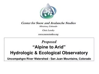
Center for Snow and Avalanche Studies Silverton, Colorado Chris Landry www.snowstudies.org. Proposed “Alpine to Arid” Hydrologic & Ecological Observatory Uncompahgre River Watershed - San Juan Mountains, Colorado.

E N D
Center for Snow and Avalanche Studies Silverton, Colorado Chris Landry www.snowstudies.org Proposed“Alpine to Arid” Hydrologic & Ecological Observatory Uncompahgre River Watershed - San Juan Mountains, Colorado
Conducting Long-Term Mountain System Monitoring 2001 2005 2006
Mountain Observatory Research and Monitoring Themes: Bales et al. (2006) priorities for improving hydrologic understanding: “ … to better understand the processes controlling the partitioning of energy and water fluxes within and out from these systems …” “ … to better understand feedbacks between hydrologic fluxes and biogeochemical and ecological processes …” GLOCHAMORE Research Strategy (2005): Socio-economic questions are integrated with physical process questions. CIRMOUNT, in Mapping New Terrain (2006): water supply, forest dieback, urban-wildland issues, wildfire, and biodiversity and wildlife. NEON (2010): expand measurements of environmental variability and gather ecological data along elevation, precipitation, and land-use gradients.
DOI-USGS Circular 1331 - 2009 Sec. 2: …monitoring needs to focus on locations that describe the climate signal …
Senator Beck Basin & Uncompahgre Watershed Sentry Site for Climate Change
Peak 13,510’ 7,600’ 11,030’ Alpine to Arid Observatory Upper Uncompahgre River Watershed to Ridgway Reservoir Elevations 14,150’ to ~6,850’ (pool) 264 sq. mi. drainage area 6,878’
149 sq mi 79 sq mi 1 sq mi xx sq mi 264 sq mi Drainage Area Existing Infrastructure 98,000 acre feet annual inflow at Ridgway Reservoir
290 ha Operated by CSAS under USFS Special Use Permit with Uncompahgre National Forest SBSP SASP SBSG PTSP
SASP Instrumentation 6 m Mast Campbell CR10X Dataloggers (2), Multiplexer (1) Campbell Precipitation Gauge Wind Speed & Direction (2) Air Temp and RH (2) Barometric Pressure Height of Snow Broadband SW (2 up, 1 down, shadow array) NIR SW (1 up, 1 down) Pyrgeometer (1 up) Infrared Snow Surface Temp Snow Temperature (5) Soil Temperature (4) Soil Volumetric Water Content Soil Heat Flux Swamp Angel Study Plot 11,050’ – 3,368 m
SBSP Instrumentation 10 m Mast Campbell CR10X Dataloggers (2), Multiplexer (1) Wind Speed & Direction (2) Air Temp and RH (2) Height of Snow Broadband SW (2 up, 1 down, shadow array) NIR SW (1 up, 1 down) Pyrgeometer (1 up) Infrared Snow Surface Temp Snow Temperature (5) Snow Wetness Sensor Soil Temperature (4) Soil Volumetric Water Content Soil Heat Flux Pk 13,510’ Senator Beck Study Plot 12,200’ – 3,719m
PTSP Instrumentation 10 m Mast Campbell CR10X Datalogger Wind Speed & Direction Air Temp and RH Pk 13,510’ SBSP Putney Study Plot 12,325’ –3,757 m Putney Study Plot 12,325’
SBSG Broad-crested, notched weir 0.1 – 30 cfs capacity Campbell CR10x Datalogger Stage – Druck transducer Stage – staff gauge Water Temp and Conductivity Senator Beck Stream Gauge 11,030’ –3,362 m
149 sq mi 79 sq mi 1 sq mi xx sq mi 264 sq mi Total Area Upper Uncompahgre River Watershed Infrastructure ~ 98,000 acre feet average yield at Ridgway Reservoir
Ouray #09146020 Elev. 7,600’ May 22, 2011
Near Ridgway #09146200 Elev. 6,878’ May 22, 2011
CSAS motives for Alpine to Arid Program Integrative science opportunity Agency utilization of Senator Beck Basin CSAS supports stakeholder-driven applied research
Alpine to Arid - Next Steps • Firming of agency engagement, science goals, budgets • Formalizing Alpine to Arid program structure, CSAS role, CSAS O&M support • Infrastructure development & operations plan (what instruments, for what purpose, operated by whom) • Securing additional monitoring infrastructure sites, as required • New monitoring site development • Engagement with academic partners clandry@snowstudies.org