Download
1 / 40
400 likes | 418 Views
This summary presentation provides an overview of the California GIS Strategic Plan's Phase 2, which aims to develop a robust and efficient spatial data infrastructure in California. The plan focuses on regional collaboration, governance recommendations, and data sharing best practices.

E N D
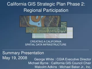
Regional Participation California GIS Strategic Plan Phase 2: CREATING A CALIFORNIASPATIAL DATA INFRASTRUCTURE Summary PresentationMay 19, 2008 George White : CGIA Executive DirectorMichael Byrne : California GIS Council ChairMalcolm Adkins : Michael Baker Jr., Inc.
CA GIS Strategic Plan Vision • The vision guiding the CA-SDI Draft Strategic Planning process is for California to create and maintain a robust and efficient spatial data infrastructure that provides quality geospatial information in the service of improving quality of life for all Californians.
Project Objective • Work with the California GIS Council lead representative to solicit, identify, summarize, and integrate regionalperspectives into a draft Strategic Plan work product that contributes to development of a California Spatial Data Infrastructure (CA-SDI).
Phase 2 Funding • National Spatial Data Infrastructure (NSDI) Cooperative Agreements Program (CAP) • CAP grants provide seed funds to assist in implementing the components of the NSDI
CA SP P2 Project Team Sponsors: California Geographic Information Association California GIS Council Consultant: Michael Baker Jr., Inc.
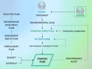
Project Approach 1 2 3 4 5
Regional Collaborative Outreach 1 • Validation of primary point-of-contact • Updated statewide register
Pre-Workshop Survey 2 • Online survey, distributed to each Regional Collaborative. 100% feedback.
Workshop Participation 3 • Current Situation • Requirements • Organizational Needs; and • Implementation
Current Situation 3 • Communication / Participation • Awareness / Education • Data Sharing / Data Accuracy • Funding
Post-Workshop Web Forum 4 • Designed to further explore concepts gained from the Workshops.
Survey / Workshop / Web Forum 4 WEAKNESSES STRENGTHS Accentuate Correct OPPORTUNITIES THREATS(BARRIERS/CONSTRAINTS) Develop Mitigate
Taking Regional Feedbackto Recommendations 5 • Strategic Plan is intended to be a multi-year plan • Initial recommendations for review • Develop process for prioritization • Initially assigned to theCalifornia GIS Council and the California Geographic Information Association
Governance Recommendations 5 GR1: CGIA to collaborate with Counties who have designated Geographic Information Officers to understand how they are organized, funded, and staffed.
Governance Recommendations 5 GR2: CGC develop Regional Collaborative Coordination Criteria as a variation on the NSGIC State Coordinator nine coordinating criteria to evaluate Regional Collaboratives. The evaluation criteria will clarify how the CGC can assist each Collaborative.
Coordination Criteria NSGIC believes that the following Coordination Criteria are essential to fully enable statewide geospatial coordination activities: • Strategic and business plans • A full-time paid GIS coordinator and staff • Clearly defined authority and responsibility for coordination • A relationship with the chief information officer • A political or executive champion is involved in coordination • A tie into national programs • An inter-governmental working environment free of "turf wars" • Sustainable funding mechanisms • Contracting authority and cost sharing mechanisms • Statewide coordination efforts that can be a conduit for federal initiatives
Governance Recommendations 5 GR3: CGIA to take increase advocacy of key California needs that the CGC is unable to promote. GR4: CGC and CGIA to discuss, prioritize, and communicate the key GIO support areas that the Regional Collaboratives have requested assistance. GR5: CGC and CGIA to continue promotion of a state Geospatial Information Office with a Geospatial Information Officer.
Data Recommendations 5 DR1: CGC and CGIA to collect/ review/ refine/ and distribute Data Sharing Best Practices template. DR2: CGC and CGIA to re-evaluate functionality of CaSIL to load, discover, and download framework data. DR3: CGC to evaluate, document, and promote the availability of state agency third party data licensing agreements.
Data Recommendations 5 DR4: CGC to form a Technology Work Group to investigate the most applicable distribution model for the CA-SDI. DR5: CGC to explore the use of GIS Centers and Academic Centers as data hosts. DR6: CGC to vet the concept of libraries as historical data repositories to enable temporal analysis.
Data Recommendations 5 DR7: CGC to pursue implementation of CA Geospatial Framework Data Plan prioritized data sets published in September 2006. Discussed approaches are 1) With funding begin development/compilation of a data set or, 2) Without funding prototype a small geographic area with most/all prioritized data sets.
Data Recommendations 5 DR8: CGC and CGIA promote educational sessions with the Regional Collaboratives and four California URISA Chapters on the Imagery Business Plan and Best Practices Report.
Finance Recommendations 5 FR1: CGIA to deliver additional Financial Sustainability education sessions, in collaboration with URISA chapters, throughout California. FR2: CGIA, collaborating with the CGC, to apply for multiple 2009 FGDC CAP Grants to address initiatives as discussed in the April 2008 CA GIS Council meeting and captured in this Plan in Section 7.5 CalGIS 2008 Live Feedback Forum.
Finance Recommendations 5 FR3: CGC to form Infrastructure Work Group to develop concept of GIS as a critical infrastructure to meet numerous policy and business needs across California. FR4: CGC to form Grant Work Group for regional and state funding. FR5: CGC and CGIA to evaluate how to obtain larger sustainable funding for the development/compilation of the CA-SDI.
Marketing Recommendations 5 MR1: CGC and CGIA work in cooperation to take June 2008 Executive GIS Event to the Regional Collaboratives. More than a Map: How Government Agencies are Collaborating on Geographic Information for Better Public Services A Safer California, A Growing California, A Healthy California, A Well Mobilized California, An Open California, and A Greener California
Marketing Recommendations 5 MR2: CGC and CGIA interact with the four California URISA Chapters to increase awareness of the prioritized CA-SDI as published in the CA Geospatial Framework Draft Data Plan in September 2006, and promote the recommendations in this GIS Strategic Plan Phase 2: Regional Participation.
Marketing Recommendations 5 MR3: CGC and CGIA to assess the value and ability of representatives to outreach to other relevant organizations to promote adoption of CA-SDI. MR4: CGC and CGIA to re-assess, re-define, and re-promote CaSIL as the central repository to post, discover, and download CA-SDI data.
Marketing Recommendations 5 MR5: CGC and CGIA should update “The state of GIS in California” tri-fold annually in advance of the NSGIC annual conference and both email push and post to their respective web sites to increase the awareness of geospatial activity in California.
Marketing Recommendations 5 MR6: Develop and web post on CGC and CGIA contact directories: 1) Variation on the CGC Members list to show key GIS contact information per represented agency or entity. 2) Regional Collaborative contact list. 3) Evaluate re-instating an updated Geospatial Yellow Pages for all GIS practitioners. MR7: Create and maintain directory of geospatial-oriented academic programs on CGC and CGIA web.
Interconnected Geospatial Initiatives California GIS Strategic Plan Phase 1: CA SDI Phase 2: Regional Participation California Geospatial Framework Draft Data Plan Metadata Training Imagery Business Plan and Best Practices Data Sharing Training
Governance Recommendations GR GR1: CGIA to collaborate with Counties who have designated Geographic Information Officers to understand how they are organized, funded, and staffed. GR2: CGC develop Regional Collaborative Coordination Criteria as a variation on the NSGIC State Coordinator nine coordinating criteria to evaluate Regional Collaboratives. The evaluation criteria will clarify how the CGC can assist each Collaborative. GR3: CGIA to increase advocacy role of key California needs that the CGC is unable to promote. GR4: CGC and CGIA to discuss, prioritize, and communicate the key GIO support areas that the Regional Collaboratives have requested assistance. GR5: CGC and CGIA to continue promotion of a state Geospatial Information Office with a Geospatial Information Officer.
Data Recommendations DR DR1: CGC and CGIA to collect/ review/ refine/ and distribute Data Sharing Best Practices template to Regional Collaboratives. DR2: CGC and CGIA to re-evaluate functionality of CaSIL to load, discover, and download framework data. DR3: CGC to evaluate, document, and promote the availability of state agency third party data licensing agreements. DR4: CGC to form a Technology Work Group to investigate the most applicable distribution model for the CA-SDI data sets. DR5: CGC to explore the use of GIS Centers and Academic Centers as data hosts. DR6: CGC to vet the concept of libraries as historical geospatial data repositories to enable future temporal analysis. DR7: CGC to pursue implementation of CA Geospatial Framework Data Plan prioritized data sets published in September 2006. Discussed approaches are 1) With funding begin development/compilation of a data set or, 2) Without funding prototype a small geographic area with most/all prioritized data sets. DR8: CGC and CGIA promote educational sessions with the Regional Collaboratives and four California URISA Chapters on the Imagery Business Plan and Best Practices Report.
Finance Recommendations FR FR1: CGIA to deliver additional Financial Sustainability education sessions, in collaboration with URISA chapters, throughout California. FR2: CGIA, collaborating with the CGC, to apply for multiple 2009 FGDC CAP Grants to address initiatives as discussed in the April 2008 CA GIS Council meeting and captured in this Plan in Section 7.5 CalGIS 2008 Live Feedback Forum. FR3: CGC to form an Infrastructure Work Group to develop concept of the CA-SDI framework data sets as a critical infrastructure necessary to meet numerous policy and business needs across California. FR4: CGC and CGIA to form a Grant Work Group focused on identifying and applying for regional and state funding. FR5: CGC and CGIA to evaluate how to obtain larger sustainable funding for the development/compilation of the CA-SDI.
Marketing Recommendations MR MR1: CGC and CGIA work in cooperation to take the June 2008 Executive GIS Event to the Regional Collaboratives. The event is focused on the business value of GIS as opposed its value as a technology: MR2: CGC and CGIA interact with the four California URISA Chapters to increase awareness of the prioritized CA-SDI as published in the CA Geospatial Framework Draft Data Plan in September 2006, and promote the recommendations in this GIS Strategic Plan Phase 2: Regional Participation. MR3: CGC and CGIA to assess the value and ability of representatives to outreach to other relevant organizations to promote adoption of CA-SDI. MR4: CGC and CGIA to re-assess, re-define, and re-promote CaSIL as the central repository to post, discover, and download CA-SDI data. MR5: CGC and CGIA should update “The state of GIS in California” tri-fold annually in advance of the NSGIC annual conference and both email push and post to their respective web sites to increase the awareness of geospatial activity in California. MR6: Develop and post on CGC and CGIA web sites geospatial contact directories: 1) CGC, 2) Collaboratives, 3) Yellow Pages MR7: Create and maintain directory of geospatial-oriented academic programs on CGC and CGIA web sites.
Regional Participation California GIS Strategic Plan Phase 2: CREATING A CALIFORNIASPATIAL DATA INFRASTRUCTURE George White : CGIA Executive Director Michael Byrne : California GIS Council Chair Malcolm Adkins : Michael Baker Jr., Inc.