Download

1 / 116
1.17k likes | 1.2k Views
Learn about jet streams, polar jet characteristics, airmass formation, classification, fronts, and how to identify them on surface maps. Explore the relationship between air masses and weather patterns.

E N D
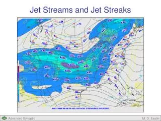
Jet Streams • Regions of air that flow much faster than surrounding air • Speeds usually between 100 - 200 knots • Defined as speeds of 50 kts or greater • Can be found at different altitudes: • Semi-permanent jets are about 10 km above surface • Polar jet • Subtropical jet • Transitory jets can form about 1500 meters above surface • Called low-level jets • “Winding tube of air” • Like a river of air • Dimensions of semi-permanent jets: • 1,000s of km long (E-W), 100s of km wide (N-S), a few km deep (top-bottom)
The Polar Jet • Commonly referred to as THE Jet Stream • Above the polar front • Cold temperatures to the north • Warm temperatures to the south • Affects our weather the most • Type of air in our region (warm or cold), is related to the position of the jet • Important steering and exhaust mechanism for Mid-Latitude Cyclones (Lows)
300 mb (9000 m) winds versus 850 mb (1500 m) temperature What relationship do you see?
Current Jet Stream • Can be found at • http://vortex.plymouth.edu/~stmiller • See: Toolbox => North American Upper Air => 200 MB or 300 MB
Airmasses • Airmass • Large body of air with similar temperature and moisture characteristics • Dimensions: • 100,000’s km2 (horizontal) • Up to three km deep (vertical) • Form when a large mass of air spends a lot of time over a source region • Source regions are regions of the Earth’s surface with homogeneous characteristics
Source regions affecting the U.S. • Gulf of Mexico • Atlantic Ocean • Pacific Ocean • Desert Southwest and Mexican Plateau • North Canadian Provinces
Airmass Classification • Based on temperature and moisture content Dry air comes from the middle of continents (c), and moist air comes from the oceans (m) Warm air comes from the tropics (T), and cold air comes from the polar (P) or the Arctic/Antarctic regions (A) * A airmasses are colder than P airmasses
Airmass classification • mT – maritime tropical • moist and warm • mP – maritime polar • moist and cold • cT – continental tropical • dry and warm • cP – continental polar • dry and cold • cA – continental arctic • dry and very cold
Fronts • Front - boundary between two airmasses of differing temperature and/or moisture characteristics
Airmass (cP) front Airmass (mT)
Types of Fronts • Cold Fronts • Warm Fronts • Stationary Fronts • Occluded Fronts • Dry Lines
Identification of Fronts • To Identify a front on a surface map look for: • (1) sharp changes in temperature, • (2) changes in moisture content (dew point), • (3) shift in wind direction, • (4) regions of precipitation, and • (5) trough of low pressure • A sharp bend in the isobars is often present
Cold Front • A transition zone where a cold airmass advances and replaces a warm airmass
Shown as blue line with triangular pips • Point to direction of cold air flow • Generally moves E or SE • Usually fast moving, esp. in summer • May have showers and thunderstorms (cumuliform clouds) • On eastern side of front • May be severe • Band of showers is usually narrow • Colder, drier conditions after front passes • Wind shift from southerly to northwesterly • 3-D structure: steep slope
Warm Front • A transition zone where advancing warm air replaces retreating cold air
Red line with semi-circular pips • Point to direction of warm air flow • Generally moves N or NE • May have precipitation • On northern side of front • Due to overrunning(warm air sliding over cold air) • Steady NS-type (stratiform) precipitation more common than showery CB type (cumuliform) • Winter precipitation may include • snow, ice pellets (“sleet”), freezing rain • Warmer, more humid conditions after front passes • Wind shift from easterly to southerly • 3-D structure: gentle slope (not steep)