Download
1 / 20
210 likes | 315 Views
Explore jet stream movements & weather patterns based on upper-level geopotential, wind strength, and tropopause observations for accurate forecasting. Gain insights into midlatitude weather systems & forecasting methodologies.

E N D
WV images and Jet StreamsCases Nuno Moreira (nuno.moreira@meteo.pt) Instituto de Meteorologia, Lisboa, Portugal 2003
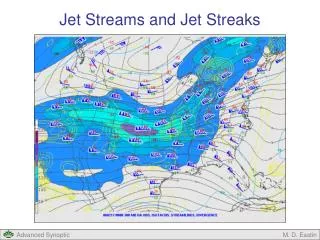
Jets and geopotential upper level trough and ridge16/2/97 - 1800/1830UTC
Jet Stream - 2 “branches” 22/4/99 - 1200/1230 UTC • Keyser and Shapiro (1986)
Strong wind – P.Douradas (1380m)24/4/01 - 1200 e 1800 UTC • 11 km/h 50 km/h
… Mean wind and gust …in Penhas Douradas (1380 m) 24/00UTC-25/12UTC 24/18UTC
Strong wind - Penhas Douradas29/4/01 - 1200 UTC • Observations: 40-50 km/h
… and tropopause map29/4/01 - 1200 UTC • Operational tropopause
Jet “crosses” the front 19/9/99 - 0600/0630 UTC • Bluestein (1993)
And strong wind - Penhas Douradas29/3/01 - 0000, 0600, 1200 UTC
References • Bader, M.J., Forbes, G.S., Grant, J.R., Lilley, R.B. e Waters, A.J., 1995: Images in weather forecasting. Cambridge University Press, Cambridge, 499 pp. • Bechtold, P., 2000: Atmospheric moist convection: effects, concepts and modelling/forecast. Módulo do Curso “Weather forecasting in the midlatitudes” realizado na MeteoFrance de 4-15 Dezembro 2000 [ver relatório VAP01/01, Instituto de Meteorologia] • Bluestein, H.B., 1993: Synoptic-Dynamic Meteorology in Midlatitudes, Vol.II: Observations and Theory of Weather Systems. Oxford University Press, Oxford, 594 pp. • Boyle, J.S. e Bosart, L.F., 1986: Cyclone-Anticyclone couplets over North America. Part II: Analysis of a major cyclone event over the Eastern United States. Mon. Wea. Rev., 114, 2432-2465. • Elbern, H., Hendricks, J. e Ebel, A., 1998: A climatology of tropopause folds by global analysis. Theor. Appl. Climatology, 59, 181-200. • Elizaga, F., Martin, F., Riosalido R., Carretero, O., Elvira, B. e Garcia, A., 1996: Imágenes de vapor de agua: uso en el diagnostico de niveles altos. IV Simposio Nacional de Predección. Memorial “Alfondo Ascaso”, Madrid, 15-19 Abril 1996, INM. • Grahame, N., 1998: Christmas Eve storm. Review of interesting synoptic cases. Fourth Meeting of the Working Group on Cooperation between European Forecasters (WG CEF). Set. 98 Comunicação oral. • Hirschberg, P.A. e Fritsch, J.M., 1991b: Tropopause ondulations and the development of extratropical cyclones - Part II: Diagnostic Analysis and coceptual model. Mon. Wea. Rev., 119, 518-550. • Hoskins, B.J., McIntyre, M.E. e Robertson, A.W., 1985: On the use and significance of isentropic potencial vorticity maps. Quart. J. Roy. Meteo. Soc., 111, 877-946. • Joly, A e Santurette, P., 2000: Turning dynamical ideas into forecast practice: a proposal for a renewed graphic summary of the synoptic scale situation. Centre National de Recherches Météorologiques, Service Central d´Exploitation Météorologique. Módulo do Curso “Weather forecasting in the midlatitudes” realizado na MeteoFrance de 4-15 Dezembro 2000 [ver relatório VAP01/01, Instituto de Meteorologia]
References • Keyser, D. e Shapiro, M.A., 1986: Review – A review of the structure and dynamics of upper-level frontal zones. Mon. Wea. Rev., 114, 452-499. • Malardel, S., 2000: Weather forecasting in midlatitudes regions - Large scale dynamics in the midlatitudes. Módulo do Curso “Weather forecasting in the midlatitudes” realizado na MeteoFrance de 4-15 Dezembro 2000 [ver relatório VAP01/01, Instituto de Meteorologia] • Moreira, N., 1999: Utilização de imagens de vapor de água na avaliação de campos previstos por Modelos numéricos. Instituto de Meteorologia. • Morgan,M.C. e Nielson-Gammon, 1998: Using tropopause maps to diagnose midlatitude weather systems. Mon. Wea. Rev., 126, 2555-2579. • NOAA, 1991: Water vapor imagery – Interpretation and applications to weather analysis and forecasting. NOAA Technical report NESDIS 57, National Oceanic and Atmospheric Admnistration, Washington, 213 pp. • Prates, F., 1996: Utilização de cartas de vorticidade potencial isentrópica no diagnóstico dos processos de ciclogénese. Nota Técnica. Instituto de Meteorologia. • Romero, R., 2000: Sensitivity of a heavy rain producing Western Mediterranean cyclone to embedded potencial vorticity anomalies. Submetido ao Quarterly Journal of the Royal Meteorological Society. • Santurette, P., 1998: About new products and new methods for synoptic forecast in Meteo-France. Casos de estudo apresentados no curso sobre previsão na Meteo-France, Dez. 98. Comunicação oral.