Download
1 / 14
140 likes | 271 Views
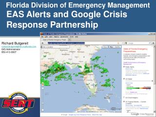
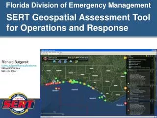
Florida Division of Emergency Management. SERT Geospatial Assessment Tool for Operations and Response. Richard Butgereit richard.butgereit@em.myflorida.com GIS Administrator 850-413-9907. http://map.floridadisaster.org/GATOR Geospatial Assessment Tool for Operations and Response

E N D
Florida Division of Emergency Management SERT Geospatial Assessment Tool for Operations and Response Richard Butgereit richard.butgereit@em.myflorida.com GIS Administrator 850-413-9907
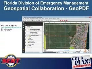
http://map.floridadisaster.org/GATOR Geospatial Assessment Tool for Operations and Response web mapping application real-time data like weather radar, watches, storm reports base map, event, and post-event data GATOR
11/08 – installed ArcGIS Server, the engine behind GATOR 02/09 – Virtual USA Regional Operational Platform Pilot project begun 07/09 – started running development GATOR, based upon VIPER 09/09 – started serving KML network links for Google Earth users 11/04/09 – GATOR deployed for ROPP capstone exercise 11/10/09 – first real-world use of GATOR directly following exercise with Tropical Storm Ida 01/10 – GATOR used with both hard freezes in early January and with Operation Haiti Relief throughout the month 05/10 – 09/10 GATOR used heavily for Deepwater Horizon Response 10/10 – focus on integrating additional data sources into GATOR 05/11 – SERT GATOR created, secured for State Emergency Response Team 07/11 – SWO GATOR created, integrating State Watch Office daily incidents Timeline
SERT GATOR Specifically for members of the SERT, embedded access through EM Constellation and EMC Test All hazards data (NWS, USGS) , traffic information (DOT/Florida 511) Operational data (Mission and information messages from EMC, full SERT RECON reports, Logistics) SWO GATOR Specifically for members of the SERT, embedded access through SWO Incident Tracker All hazards data (NWS, USGS) , traffic information (DOT/Florida 511) Incident from the SWO Incident Tracker FloridaDisaster.org GATOR Open access All hazards data (NWS, USGS) , traffic information (DOT/Florida 511) Less operational data Different Versions of GATOR
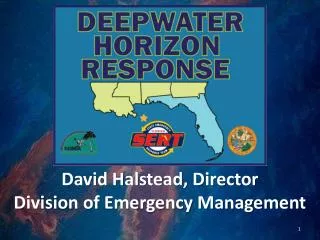
GATOR and the Deepwater Horizon Response
SERT RECON Report application RECON Reports • Existing application for the SERT RECON Team • Built primarily for hurricanes and floods • Teams trained in use, reports triaged by RECON liaisons • For this response, used to track reports of tar balls, recoverable product, shoreline and boom conditions
https://seoc.floridadisaster.org/SWO modernized system improved incident reporting and tracking SWO GATOR (visualize incidents) upcoming tasks migrate archived data from old system Integration with new notification system SWO Incident Tracker