Revolutionary War Mapwork Guide
Detailed directions and key events for mapping Revolutionary War battles and figures. Includes Lexington & Concord, Bunker Hill, Invasion of Canada, British movements, and more.

Revolutionary War Mapwork Guide
E N D
Presentation Transcript
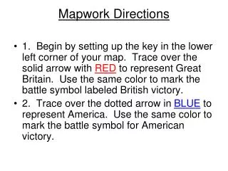
Mapwork Directions • 1. Begin by setting up the key in the lower left corner of your map. Trace over the solid arrow with RED to represent Great Britain. Use the same color to mark the battle symbol labeled British victory. • 2. Trace over the dotted arrow in BLUE to represent America. Use the same color to mark the battle symbol for American victory.
Mapwork Directions • On the back of your map, begin a list of Key People. • Place General Thomas Gage, Paul Revere, and William Dawes on the list.
Mapwork DirectionsLexington & Concord • 1. Draw an arrow (British troopmovement) from Boston to Lexington and Concord. • 2. Using black pen or pencil, print Apr. 1775 next to Lexington and Concord. • 3. Color the battle symbol to represent anAmerican victory.
Battles of Lexington & Concord • Battles of Lexington and Concord were the first battle of the American Revolution, in which American militia fought back against British troops ordered to capture minutemen weapons stores at Concord • General Thomas Gage ordered British troops to Lexington to try to capture Samuel Adams & John Hancock, and to Concord where the colonists had stored arms & ammunition. Paul Revere & William Dawes warned the minutemen that the redcoats were coming. Adams & Hancock escaped from Lexington, but the British destroyed military stores at Concord. After the skirmishes at Lexington & Concord, the British marched back to Boston under a steady fire from the minutemen. The redcoats suffered heavy casualties.
Mapwork DirectionsBattle of Bunker Hill • 1. Print June 1775 next to Bunker Hill. • 2. Color the battle symbol to represent a British victory.
Battle of Bunker Hill • Following the battles of Lexington & Concord, the British returned to Boston. Some 10,000 colonial militiamen took up positions around the city. When the Americans occupied Breed’s Hill, the redcoats attempted to drive them off. The first two British attacks failed, but the third assault on the hill succeeded when the Americans ran out of ammunition.The British won the battle but lost far more soldiers than the patriots. The patriots displayed skill & courage, and showed that they would not be easily defeated.
Mapwork DirectionsInvasion of Canada • 1. On the back of your map, add Ethan Allen to Key People.FindTiconderoga and Crown Point onyour map.Color the battle symbols to represent American victories and print May 1775. • 2. Trace Arrow 2 (Americans) from FortTiconderoga to Montreal.Print Nov. 1775 next to Montreal. • 3. Color the battle symbol at Montreal to represent an American victory.
Mapwork DirectionsInvasion of Canada (cont.) • 4. Trace Arrow 3 to Quebec. • 5. Trace Arrow 4 from Boston toQuebec. • 6. Color the battle symbol at Quebec to represent a British victory. • 7. Print Dec. 1775 next to Quebec.
Invasion of Canada • Ethan Allen & the Green Mountain Boys of Vermont, with the help of Benedict Arnold, captured the British forts at Ticonderoga & Crown Point. These successes in northern New York opened the way for a two-pronged invasion of Canada. The Americans hoped they could win the assistance of French-Canadians who disliked the British. American commander Richard Montgomery led an expedition north to Montreal, which he captured. Montgomery then advanced to Quebec where he joined forces with Benedict Arnold, who had marched north from Boston. The Americans attacked Quebec during a blizzard on December 31, 1775, but were driven back. Montgomery was killed and Arnold seriously wounded. The Americans retreated to Fort Ticonderoga.
Mapwork DirectionsThe British Withdraw from Boston 1. Trace Arrow 5 from Boston to NovaScotiaand add General Wm. Howe to your list of Key People. • 2. Trace Arrow 6 to show the movement of British forces from Nova Scotia toLongIsland.
The British Withdraw from Boston • Two weeks after the Battle of Bunker Hill, General George Washington took command of the Continental Army in Boston. Cannons taken at Fort Ticonderoga were positioned on Dorchester Heights overlooking Boston harbor. Fearing the cannons, British general William Howe, who had replaced General Gage, withdrew from Boston to Nova Scotia, Canada. Five months later, General Howe landed on Long Island with the intention of capturing New York City. He was met by General Washington, who had moved the Continental Army south from Boston.
Mapwork DirectionsThe British Capture New York City 1. Color the battle symbol to represent British victories at New York. Print Oct. 1776 next to the battle symbol. Add Nathan Hale to your list of Key People. • 2. Print Oct. 1776 Next to New York on your map.
The British Capture New York City • Over the next four months, the British army won the battles of Long Island, New York & White Plains. General Howe’s powerful forces overwhelmed the smaller and poorly equipped American army. Howe missed several chances to pursue & destroy the retreating Americans. General Washington, using all of his skills as a commander, managed to escape into New Jersey. It was during the New York campaign that Nathan Hale was captured & hung as a spy on orders from General Howe.
Mapwork DirectionsBattles of Trenton and Princeton • 1. Trace Arrow 7 to show Washington’s retreatthrough New Jerseyand subsequent attacks on Trenton & Princeton. Add Gen. George Washington to Key People. • 2. Color the battle symbols at Trenton & Princeton to represent American victories. • 3. Print Dec. 1776 next to Trenton and Jan. 1777 next to Princeton.
Battles of Trenton & Princeton • New York City was now in the hands of the British. The ragged Continental Army was on the verge of defeat. Even Washington, retreating with his shoeless army through the cold winter rain told a friend, “The spirits of the people have shrunk. Without fresh troops, I think the game is pretty near up.” Thomas Paine wrote in his pamphlet “The Crisis” that, “These are the times that try men’s souls.” Washington struck back with two quick triumphs. Crossing the icy Delaware River on Christmas night, he surprised a large Hessian force at Trenton, New Jersey. A week later, he took Princeton. These victories boosted American spirits & attracted more men into the Continental Army.
Mapwork DirectionsBattles of Oriskany and Saratoga • 1. Trace Arrow 8to Oriskany. Color the battle symbol to represent an Americanvictory. Print Aug. 1777 next to Oriskany. • 2. Trace Arrow 9 from New York City to Philadelphia. Color the battle symbols at Brandywine (Sept. 1777) & Germantown (Oct. 1777) to represent British victories. Put the dates on the map. • 3. Trace Arrow 10 to Saratoga. Color the battle symbol to represent an Americanvictory. Print Oct. 1777. Put Burgoyne and Gates on theKey Peoplelist.
Battles of Oriskany and Saratoga • The battle of Saratoga was part of a large scale British invasion, the American victory at Saratoga was responsible for persuading the French to sign The Treaty of Alliance and join with America in fighting the British • The British, in 1777, planned to drive New England from the other colonies by capturing New York state. The plan had three parts: 1) General John Burgoyne was to march from Canada to Albany, New York; 2) Colonel Barry St. Leger was to lead an army from Canada to Oswego, and then eastward to Albany; 3) General William Howe would move north from New York City to Albany. But the British plan failed. St. Leger was defeated at the Battle of Oriskany. Instead of marching north to Albany, General Howe moved his army to Philadelphia, winning battles at Brandywine & Germantown against General Washington.General Burgoyne was defeated at the Battle of Saratoga by American forces commanded by General Horatio Gates. The news of the American victory at Saratoga convinced France to sign the Treaty of Alliance with the United States.
Mapwork DirectionsThe British Leave Philadelphia • 1. Put Baron von Steubenon the Key People list. Print Winter 1778 next to Valley Forge. • 2. In Box 1 along the right side of the map, print May 1778: Congress ratifies the Treaty of Alliance with France.
The British Leave Philadelphia • The redcoats spent the winter of 1777-1778 in Philadelphia, the capital of the United States. The city had fallen into British hands after the battles of Brandywine & Germantown. Meanwhile, the Continental Army set up winter headquarters at nearby Valley Forge. Washington’s men suffered from a shortage of food, clothing, & other supplies. Baron von Steuben reorganized & trained the Continentals to prepare them for the military campaigns of 1778. By May, large-scale French aid, including an army & a powerful fleet, began arriving in the United States. Feeling increased pressure, General Henry Clinton, who succeeded Howe, abandoned Philadelphia and moved British forces back to New York City.
Mapwork DirectionsClark Conquers the Northwest • 1. Trace Arrow 11 to represent American troop movement. Put General Rogers Clarkon the Key People list. • 2. Color the battle symbols at Kaskaskia & Vincennes to represent American victories. • 3. Print July 1778 next to Kaskaskia. • 4. Print Feb. 1779 next to Vincennes.
General Rogers Clark Conquers the Northwest • During the war, the British encouraged their Indian allies to attack American settlers on the western frontier. To end these raids, General Rogers Clark led a band of frontiersmen into the present-day states of Illinois & Indiana. Clark’s men captured the British forts at Kaskaskia & Vincennes.
Mapwork DirectionsThe War at Sea • 1. In Box 2 along the right side of the map, print Sept. 1779: John Paul Jones captures the “Serapis.” Add Captain Jones to the Key People list. • 2. In the Atlantic Ocean, color the largest ship to represent British naval forces. Next to it print British Navy. • 3. Color the smaller ship to represent Americannaval forces. Next to it print Continental Navy/privateers. • 4. Add privateersto the Key People list.
The War at Sea • Throughout the Revolutionary War, American naval forces tried to avoid a direct confrontation with the powerful British Navy. Instead, they concentrated on disrupting Great Britain’s trade. The small Continental Navy, with the help of about 2,000 privateers (hired sailors who assisted the small colonial fleet), inflicted heavy damage on British shipping. About 800 British ships were captured or destroyed. The most famous battle involved the “Bonhome Richard,” commanded by Captain John Paul Jones, & the British warship “Serapis.” The Americans captured the 44-gun “Serapis” after a bloody, bitter fight off the coast of Great Britain.
Mapwork DirectionsThe End of the War • 1. Color the battle symbols at Savannah (Dec. 1778), Charleston (May 1780), Camden (Aug. 1780), & Wilmington (Feb. 1781) to represent British victories. Print the dates on the map. • 2. Color the battle symbols at King’s Mountain (Oct. 1780), Cowpens (Jan. 1781), & Guilford Courthouse (Mar. 1781) to represent American victories. Print the dates on the map.
Mapwork DirectionsThe End of the War (cont). • 3. Arrow 12shows Cornwallis’ march through the South. Trace the arrow from Charleston to Yorktownand put Cornwallis on theKey Peoplelist. • 4. Trace Arrow 13to reflect Lafayette’s troops and put Lafayetteon the Key People list.
Mapwork DirectionsThe End of the War (cont). • 6. Trace Arrow 14to reflect Washington’s troops. • 7. Trace Arrow 15and to reflect Admiral de Grasse’s blockade. • 8. Color the battle symbol at Yorktown to represent American victory. Print Oct. 1781 next to it. • 9. In Box 3, print Sept. 1783: The United States & Great Britain sign the Treaty of Paris.
Battle of Yorktown • The battle of Yorktown was the last major battle of the war, where General Cornwallis became surrounded by Washington & Lafayette and ultimately surrendered
The End of the War • Most of the fighting in the last years of the war took place in the South. The British captured the coastal cities of Savannah, Charleston, & Wilmington. The British army, under General Charles Cornwallis, marched inland & defeated American forces at Camden, South Carolina. But Washington, who was containing General Clinton in New York, sent General Nathaniel Greene to the southern states. After the Continental Army won battles at King’s Mountain, Cowpens, & Guilford Courthouse, Cornwallis retreated to the coast. He marched his army to Yorktown, Virginia, which he planned to use as a base of operations. As Marquis de Lafayette occupied Cornwallis, Washington hurried south from New York with a force of 20,000 men. Meanwhile, a French fleet under Admiral de Grasse prevented the British Navy from rescuing Cornwallis. Surrounded on all sides & under a savage bombardment, Cornwallis surrendered. Yorktown was the last major battle of the war. In the Treaty of Paris, Great Britain recognized the independence of the United States.