Download
1 / 31
310 likes | 602 Views
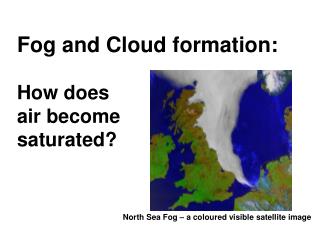
Fog and Cloud formation: How does air become saturated?. North Sea Fog – a coloured visible satellite image. Reading. Ahrens 9 th ed., Chapter 5 Condensation: Dew, Fog, and Clouds, p110-121 (8 th Ed: Chapter 5, p106-116)

E N D
Fog and Cloud formation:How does air become saturated? North Sea Fog – a coloured visible satellite image
Reading • Ahrens 9th ed., Chapter 5 Condensation: Dew, Fog, and Clouds, p110-121 (8th Ed: Chapter 5, p106-116) • Ahrens, 9th ed., Chapter 6 Stability and Cloud Development, p151-157 (8th Ed: Chapter 6: p149-155) • My last lecture: condensation of cloud droplets (micro-scale) • This lecture: specific conditions and processes that lead to condensation (macro-scale)
Dew, Frost, Haze and Fog • Dew: Common on vegetation early morning after a clear night. (a) How? Air is cooled to Td so becomes saturated. (b) Happens on clear nights because surface radiates heat and this is not trapped by a cloud cover. (c) Dew forms on vegetation because it cools more quickly than (say) a road surface; vegetation has a lower heat capacity per unit area. Dew formation releases latent heat, and this reduces the rate at which the surface cools. Therefore the dew point temperature is often the minimum night-time temperature.
(ii) Frost: Forms if dew point is below 0°C. This is now called the frost point. (a) White frost (or hoar frost) forms by ice deposition directly from the vapour, in the form of 6-sided crystals.
(b) Black frost (or black ice) forms when the dew point is just above 0°C so the dew forms first and subsequently freezes as temperature drops below 0°C. A layer of ice is formed without the creation of small crystallites. (iii) Haze: Dry haze is caused by particulate nuclei, which scatter light like the blue of the sky, and when there is some water deposition, the haze thickens and becomes wet haze.
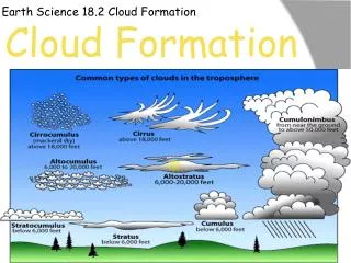
(iv) FOG – defined when visibility < 1 km • Fog is equivalent to a cloud at the surface. • Fog forms in one of three ways: • by cooling the air • by evaporation of water into the air • by mixing of two air masses such that when combined, the mixture is saturated • The types of fog are named with reference to the method by which the air becomes saturated.
ADVECTION FOG - air is cooled to saturation by having warm moist air moving over a cold surface.. San Francisco has a lot of advection fog since the surface water near the coast is much colder than the water farther off shore. Warm moist air from the Pacific Ocean is advected over the cold coastal waters, chilling the advected air from below.
UPSLOPE FOG - forms as moist air flows up an elevated plain, hill or mountain. As the air ascends, it expands, cools adiabatically (same as any ascending air), and saturates.
30 25 C T = 15 °C r = 11.5 g kg-1 B T = 30 °C r = 20 g kg-1 20 mixing ratio g kg-1 15 A T = 0 °C r = 3 g kg-1 10 But at 15 ° C rs = 10.8 g kg-1 5 0 -20 -10 0 10 20 30 Temperature °C EVAPORATION (or MIXING) FOG - formed by mixing two unsaturated air masses.
STEAM FOG - forms when cold air moves over warm water (e.g. heated outside swimming pool) water evaporates from the pool into the air, increasing the dew point and if mixing is sufficient the air above becomes saturated. The colder air directly above the water is heated from below and rises forming what appears to be steam.
Radiation cooling takes place from the top of the fog layer; mixing continues in the fog layer, further cooling the ground surface. RADIATION (GROUND) FOG - produced by the radiative cooling at the surface - common over land in late autumn and winter. - also form in low-lying areas. • Favourable conditions: • clear (cloud-free) nights (cold), • shallow layer of moist air near the ground (e.g. recent rainfall, or near water body), • 3. long nights, • 4. light winds
VALLEY FOG. Cold air and high moisture content in river valleys make them susceptible to radiation fog. Radiation fogs form at the ground and are deepest around sunrise - sometimes an increase in thickness at sunrise due to the evaporation of dew supplying moisture to the fog
The rapid drop in pressure abovean aircraft wing can result in sufficientadiabatic cooling to cause saturation 3 methods of cloud formation: 1. Cool air directly 2. Mix with colder air 3. Reduce pressure (adiabatic expansion and cooling)
Orographic uplift Lee Wave clouds rotor or Lenticular clouds
Ascendingthermals • will form ‘heap’ clouds e.g. cumulus and cumulonimbus. • (may spread out if they reach an inversion, however to form St, Sc)
Slantwise convection – forms most of the layered clouds such as Stratus. Gradient of the slope is about 1 in 100 or 200; thus air may move horizontally 200 km to ascend 1 km.
Friction near the surface causes cross-isobar flow towards low pressure Sub-geostrophicwind, due to theeffects of friction Cross-isobarflow towardslow pressure
Clicker question Air tends to __X__ above an area of __Y__pressure, causing clouds to __Z__. 1. X=ascend; Y=low; Z=form 2. X=descend; Y=low; Z=disperse 3. X=ascend; Y=high; Z=form 4. X=descend; Y=high; Z=disperse 5. Both 2 and 3 are correct 6. Both 1 and 4 are correct
Convergence occurs in areas of low surface pressure – this is why cloud is usually associated with depressions and troughs. Conversely, fine weather tends to occur when pressure is high, asit is associated with subsidence and surface divergence.
Ahrens Figure 7.16 Rising air cools at the DALR but the dew point drops (at a rate dependent on moisture content) but typically 2 °C/1000 m. Thus Ta and Td approach each other at about 8 ° C per km.
general rule for convective clouds is: cloud base 125 x (Tsurface-Td) + 200 m Calculating cloud base height
Hand-in assignment • It’s important – worth 10% of overall mark, and 1/3 of coursework mark. • Hand in by noon 9th November to Helen McKeating, Crew 211. • Include a signed ‘own work’ declaration. • Penalties for late submission