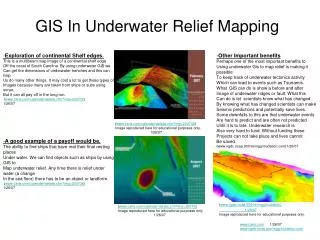
Recreation Opportunity Spectrum Mapping Using GIS
630 likes | 1.74k Views
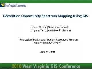
Recreation Opportunity Spectrum Mapping Using GIS. Ishwar Dhami (Graduate student) Jinyang Deng (Assistant Professor) Recreation, Parks, and Tourism Resources Program West Virginia University June 9, 2010. Outline. Introduction Objective Rationale Method Result

Recreation Opportunity Spectrum Mapping Using GIS
E N D
Presentation Transcript
Recreation Opportunity Spectrum Mapping Using GIS Ishwar Dhami (Graduate student) Jinyang Deng (Assistant Professor) Recreation, Parks, and Tourism Resources Program West Virginia University June 9, 2010
Outline • Introduction • Objective • Rationale • Method • Result • Discussion and Conclusion
Introduction • Recreation Opportunity Spectrum (ROS) is a planning framework emerged in late 1970s in the recreation systems of North America (Clark and Stankey 1979). • The objective of ROS is to help managers to determine existing supply of recreational opportunities in the area so that people can have choices for the different experiences.
Introduction • Experiences derived from recreation are related to activities within setting in which they occur. • Settings are a function of environmental factors (physical, social, & managerial). • The range of settings affect the experiences that can be provided
Introduction • Forest service ROS is based on physical, social and managerial components of a landscape and contributes to the ROS classification of six settings along a continuum of opportunities
Rationale A number of studies have applied ROS for recreational planning (Finley, 1990; Kliskey, 1998). However most studies have used manual overlays of information on maps (Boot & Cullen, 1995;More et al., 2003) which does not allow for the full demonstration of the ROS classifications.
Rationale • With the advancement of technology like GIS, ROS mapping can be done efficiently and help land use planners and resource managers to assist in determining existing recreation opportunities in the area. • Few studies have used vector based GIS to delineate ROS classification ( Peirskalla et al. 2008; Joyce & Sutton, 2009)
Objective Thus, the objective of this study is to map ROS using both raster and vector based GIS in Pocahontas County of West Virginia.
Method: Study Area Pocahontas County, West Virginia. One of the most richest county in West Virginia in terms of Natural amenities (Wang, J. 2008)
ROS Criteria Source: Pierskalla et al., 2009
Data and Software • West Virginia GIS Technical Center for road , land stewardship and populated places. • Arc map software
All roads Unimproved roads Improved roads
Binary maps were produced and reclassified Distance grids were reclassified
ROS adjusted for remoteness, size and evidence of human OR Physical setting component of ROS
Discussion and Conclusion Most of the areas in Pocahontas county are Roaded Natural (40.67%) followed by Rural (38.84%). Majority of county (Roaded natural and Rural) is suitable for nature and culture based tourism. No primitive area was found in the study site as the examined polygon did not meet all the three criteria.
More than 10.78% of the County is suitable destination for visitors who value wilderness but also desire some form of amenities (SPM). About 9.35% of the county is suitable for visitors who value wilderness (SPNM). GIS was found to be a useful tool in analyzing and visualizing the outputs of ROS. Discussion and Conclusion
Discussion and Conclusion Limitations • Raster Vector Raster • Not used social and managerial component • Used data from 1990 census and WVGAP project 2002.
Discussion and Conclusion Implications The results of the study provide information to the visitors on the type of ROS available in the area. The size of the area would also benefit agencies responsible for resource planning and management to assess the potential for the activities within the area and advertise them accordingly.
Discussion and Conclusion Implications • Helps to determine the management practice that would need to be undertaken in order to generate certain class. For, example, to maintain wilderness, close certain roads in the region. • Provide information to land use planners and resource managers on existing recreation opportunities to assist them in making decisions on appropriate land uses.
Discussion and Conclusion Future Research Long term studies dealing with size of the ROS classes changes in the area and trend of visitors could provide important insights in better planning for tourism in the area.
Literature Cited • Booth, K & Cullen R. (1995). Recreation impacts. In P.J Devlin, R.A. Corbett & C.J. Peebles (Eds). Outdoor recreation in New Zealand, a review and synthesis of the research literature. Lincoln, New Zealand: Department of Conservation and Lincoln University. • Clark, R., & Stankey, G. (1979). The recreation opportunity spectrum: A framework for planning, management, and research. U.S. Department of Agriculture Forest Science. • Joyce, K & Sutton, S. (2009). A method for automatic generation of the Recreation Opportunity Spectrum in New Zealend. Applied Geography, 29, 409-418. • Pierskalla, C.D., Sinisalchi, J.M., Selin, S. W. & Fosbender, J. (2007). Using events as a mapping concept that complement existing ROS methods. Leisure Sceience, 29, 71-89.