GIS In Underwater Relief Mapping
10 likes | 304 Views
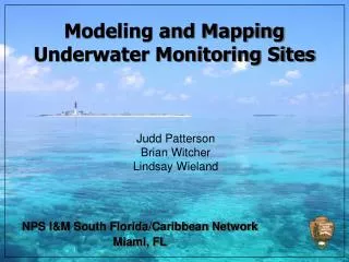
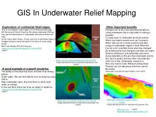
GIS In Underwater Relief Mapping. - Exploration of continental Shelf edges. This is a multibeam map image of a continental shelf edge Off the coast of South Carolina. By using underwater GIS we Can get the dimensions of underwater trenches and this can help

GIS In Underwater Relief Mapping
E N D
Presentation Transcript
GIS In Underwater Relief Mapping -Exploration of continental Shelf edges. This is a multibeam map image of a continental shelf edge Off the coast of South Carolina. By using underwater GIS we Can get the dimensions of underwater trenches and this can help Us do many other things. It may cost a lot to get these types of Images because many are taken from ships or subs using sonar, But it can all pay off in the long run. (www.caris.com/calender/details.cfm?img=200702) 1/26/07 -Other Important benefits Perhaps one of the most important benefits to Using underwater Gis to map relief is making it possible To keep track of underwater tectonics activity Which can lead to events such as Tsunamis. What GIS can do is show a before and after Image of underwater ridges or fault. What this Can do is let scientists know what has changed . By knowing what has changed scientists can make Seismic predictions and potentially save lives. Some downfalls to this are that underwater events Are hard to predict and are often not predicted Until it is to late. Underwater research is Also very hard to fund. Without funding these Projects can not take place and lives cannot Be saved. (www.ngdc.noaa.900/re/mgg/inudation.com)1/26/07 (www.caris.com/calender/details.cfm?img=200702) Image reproduced here for educational purposes only. 1/26/07 -A good example of a payoff would be. The ability to find ships that have met their final resting places Under water. We can find objects such as ships by using GIS to Map underwater relief. Any time there is relief under water (a change In the sea floor) there has to be an object or landform. (www.caris.com/calender/details.cfm?img=200708) 1/26/07 (www.ngdc.noaa.900/re/mgg/inudation) 1/26/07 Image reproduced here for educational purposes only. (www.caris.com/calender/details.cfm?img=200708 Image reproduced here for educational purposes only 1/26/07 www.caris.com 1/26/07 www.ngdc.noaa.gov/mgg/inudation.com