Download
1 / 13
130 likes | 275 Views
Michael Inggs, Department of Electrical Engineering, University of Cape Town, Private Bag, Rondebosch 7701 Mike.Inggs@uct.ac.za. Radar Remote Sensing Group University of Cape Town. Satellites enabling the Global Earth Observation System of Systems (GEOSS). “. Background.

E N D
Michael Inggs, Department of Electrical Engineering, University of Cape Town, Private Bag, Rondebosch 7701 Mike.Inggs@uct.ac.za Radar Remote Sensing Group University of Cape Town Satellites enabling the Global Earth Observation System of Systems (GEOSS)
“ Background “The GEO was formally established at the Third Earth Observation Summit in February 2005 to carry out the GEOSS 10-Year Implementation Plan. Prior to its formal establishment, the Ad Hoc GEO (established at the First Earth Observation Summit in July 2003) met as a planning body to develop the GEOSS 10-Year Implementation Plan.”. In fact, the process started at the 2002 Johannesburg World Summit on Sustainable Development, triggering the action at the next summit, in 2003. The United States, South African, Chinese and European members serve as co-chairs of the GEO Plenary and the GEO Executive Committee.
The role of Satellite Technology in Remote Sensing • Early history. • The move to space. • Issues around data volumes. • Convenient distribution from remote terrestrial sites. • Subtle pressure from the media concerning most transgressions of pollution rules.
Sensors • Optical • Radar/Microwave • Gravity • Navigation • Communications
Optical • Growth in spatial resolution. • Resolution in Wavelength resolution and range. • Downlink capabilities • Problems with cloud cover • Weather • The tyranny of orbits and daily coverage.
Radar and Microwave • All weather, day/night • Active and passive. • Growth in resolution. • Millimetric slant range change detection capability. • Scatterometers and the ocean wind and waves.
Gravity • Orbital perturbations. • Better knowledge of the earth's spheriod.
Navigation • Transit • GPS constellation • GLONASS • Galileo • Importance for • data gathering • location
Communications • Disaster coordination and warning systems. • Remote data collection. • Downlinks. • Media and environmental awareness
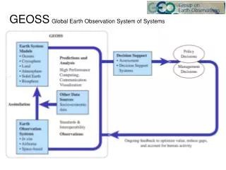
GEOSS Rationale • Huge cost of national remote sensing programmes. • Realisation we all travel on the same spaceship. • Huge volumes of underutilised data. • Duplication. • The properties of a system are always greater than the sum of the parts.
GEOSS Tasks • Disasters: Reducing loss of life and property from natural and human-induced disasters. • Health: Understanding environmental factors affecting human health and well-being. • Energy: Improving management of energy resources. • Climate: Understanding, assessing, predicting, mitigating, and adapting to climate variability and change. • Water: Improving water-resource management through better understanding of the water cycle.
GEOSS Tasks (2) • Weather: Improving weather information, forecasting and warning. • Ecosystems: Improving the management and protection of terrestrial, coastal and marine resources. • Agriculture: Supporting sustainable agriculture and combating desertification. • Biodiversity: Understanding, monitoring and conserving biodiversity. • User Engagement.
Conclusions • Probably the largest Science and Engineering project of all time. • Good example of international cooperation across the economic spectrum. • Thorough planning. • South Africa has an influential role.