Download
1 / 44
440 likes | 681 Views
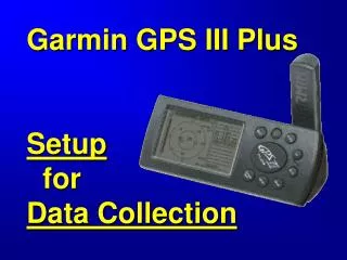
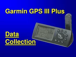
Garmin GPS III Plus Data Collection. Objectives. Collect: - Waypoints Average Position Waypoints Reference Waypoints - Multiple Tracks in One Track Log. Summary of Topics. Simulator Mark Waypoint Average Position Waypoint Reference Waypoint Tracks . Display Simulator Page* . *.

E N D
Objectives • Collect: • - Waypoints • Average Position Waypoints • Reference Waypoints • - Multiple Tracks in One Track Log
Summary of Topics • Simulator • Mark Waypoint • Average Position Waypoint • Reference Waypoint • Tracks
Display Simulator Page* * Practice data collection indoors
Collect “Mark” Waypoint Press and hold Enter -All values frozen -No values stored yet
Modify Mark Waypoint Screen Waypoint Name, max 6 characters Waypoint Symbol DO NOT EDIT-needed for ArcView Used for “Offset” Current position
Change Waypoint Symbol Highlight Waypoint Symbol Use Rocker Keypad Press Enter
Change Waypoint Name Press Enter Highlight Waypoint Name Use Rocker Keypad
Use Rocker Keypad Store Mark Waypoint Highlight “Done” Press Enter
Collect Average Position -Start with Mark Waypoint This will be name of Average Position when stored Note initial position coordinates
Press Menu Select Average Position
Open Average Position Page Press Enter Note Estimated Accuracy and Measurement Count
Save Average Position When Estimated Accuracy and Measurement Count are acceptable press “Save”
View Stored Average Position 1 position 32 positions No indication this is an Average Position
Create Reference Waypoint - Offset from Existing Waypoint • Use where: • GPS signals are blocked • - location is inaccessible
Start with NewMark Waypoint Note initial position coordinates
Modify Fields Name of Reference Waypoint when stored Select from existing waypoints Enter bearing and distance from existing waypoint to reference waypoint Note final position coordinates
View Waypoints on Map Page Note: to view waypoints on Map Page match scale on Map Page to scale in Map Setup/Pnts/Zoom
Create Reference Waypoint - Offset from Current Position • Use where: • GPS signals are blocked • - location is inaccessible
Start with NewMark Waypoint Note initial position coordinates = current location
Modify Fields Name of Reference Waypoint when stored Using initial position coordinates Enter distance then bearing from current location to reference waypoint Note final position coordinates
View Waypoints on Map Page Current location or initial position coordinates Reference Waypoint Note: to view waypoints on Map Page match scale on Map Page to scale in Map Setup/Pnts/Zoom
If arrow present, then waypoint collected will be a Map Waypoint, not a GPS- calculated waypoint Caution!
Open Track Logs Page Press Enter
Display “Track Log Options” Press Menu
Press Menu Display “Setup Logging” Press Enter
Start 1st Track Collection by Setting Record Mode to “Fill” Highlight Field Press Enter Highlight Field Press Enter
Stop 1st Track Collection by Setting Record Mode to “Off” Highlight Field Press Enter Highlight Field Press Enter
Check Memory Press Quit
DO NOT CHOOSE “Save Active Log” This option saves: - only most significant positions - maximum 250 positions
Start 2nd Track Collection by Setting Record Mode to “Fill” Highlight Field Press Enter Highlight Field Press Enter
Stop 2nd Track Collection by Setting Record Mode to “Off” Highlight Field Press Enter Highlight Field Press Enter
View Track Logs on Map Page 2nd Track 1st Track
Check Memory After Collecting 2nd Track Note memory used increase as additional tracks are collected
Summary of Topics • Simulator • Mark Waypoint • Average Position Waypoint • Reference Waypoint • Tracks
Setup Logging – Record Mode Ends collection Collects until filled Collects until “Off” selected, will overwrite
Setup Logging - Time Position collected automatically based on a time interval Max: 1900 track log positions for Active Log Approximate collection time: 1 second Interval Value – 30 min 2 second Interval Value – 60 min 5 second Interval Value – 2.5 hours
Setup Logging - Resolution Position collected automatically based on deviation to the left or right Interval Value: -When deviation to the right or left exceeds this value a track point will be collected -Units either meters or feet
1 Vs. 5 Second Interval DataMap View 1 sec interval 5 sec interval
1 Vs. 5 Second Interval Data 1 second interval 5 second interval