Download
1 / 7
70 likes | 218 Views
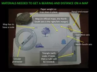
MATERIALS NEEDED TO GET A BEARING AND DISTANCE ON A MAP. Paper weight so map stays in place. Pencil and eraser. Map (in official maps, the North-South axis is the right/left margin). Map has to have a scale. East-West axis. North-South axis.

E N D
MATERIALS NEEDED TO GET A BEARING AND DISTANCE ON A MAP Paper weight so map stays in place Pencil and eraser Map (in official maps, the North-South axis is the right/left margin) Map has to have a scale East-West axis North-South axis Triangle (with scale; if none, then a ruler will be needed) Circular protractor
Sample problem: Determine the bearing of the tablet rock from the tree base. Compute actual distance in km. STEP 1: Mark the exact middle of the locations (in this case, the middle of the base of the tree) and draw a cross-hair using the triangle. Positioning the triangle is crucial to drawing an accurate cross-hair. Study the next two slides which demonstrate how the North-South and East-West lines of the cross-hair have been drawn. Cross-hair at the base of the tree
North-South line of cross-hair. Note the alignment of the top side of the triangle to the map’s East-West axis. Also note the use of the base mark as reference. Top side of triangle aligned with East-West axis of the map North-South line of the cross-hair correctly drawn Triangle uses base of the tree as reference
Sample problem: Determine the bearing of the tablet rock from the tree base. Compute actual distance in km. STEP 2: Draw a line from the origin to the destination (in this case, from tree base to tablet rock). Care must be taken to always refer to the exact middle of indicated locations. Position the circular protractor such that the zero mark is aligned with the North-South axis of the map. Zero mark aligned with map’s North Use the exact middle of locations as reference Line drawn from tree base to tablet rock
Sample problem: Determine the bearing of the tablet rock from the tree base. Compute actual distance in km. STEP 3: Read the bearing of the destination on the protractor scale. Note that the scale is inverted. In this example, the bearing is 106o. The inverted scale on the protractor is a result of its proper positioning (the zero mark aligned with the map’s North) Correct reading is 106o. The exact middle of the Tablet Rock was used as reference point.
Sample problem: Determine the bearing of the tablet rock from the tree base. Compute actual distance in km. STEP 4: To determine the distance from Tree Base to Tablet Rock, we first measure the line we drew from tree to rock. Then we use the map’s scale to convert to the desired unit of distance. See next slide for sample computation. Note that readings must be accurate. To insure this, the triangle must be positioned at exact zero with the reference mark. The correct reading is 13cm.
Sample problem: Determine the bearing of the tablet rock from the tree base. Compute actual distance in km. Study sample computation below. Use the scale of the map to convert the map distance to actual distance. Actual distance in km Map distance (as measured by the triangle scale). This is converted to actual distance in the solution.