Download
1 / 23
250 likes | 525 Views
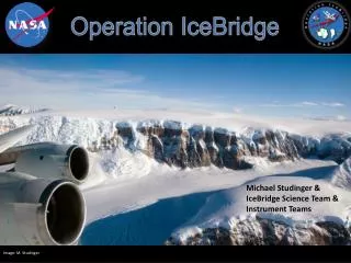
Operation IceBridge. Michael Studinger & IceBridge Science Team & Instrument Teams. Image: M. Studinger. Operation IceBridge. IceBridge Background. 2008: feasibility and cost analysis: “An analysis and summary of options for collecting ICESat-like data from aircraft”

E N D
Operation IceBridge Michael Studinger & IceBridge Science Team & Instrument Teams Image: M. Studinger
IceBridge Background 2008: feasibility and cost analysis: “An analysis and summary of options for collecting ICESat-like data from aircraft” 2009: solicited proposals for instruments for Antarctic campaigns 2009 and Arctic campaigns 2011 ad hoc community-based steering committee responsible for flight planning 2010: ROSES call for instrument teams and IceBridge Science Team members IceBridge Science Team and instrument teams selected based on competitive proposalsshift from ad hoc steering committee to directed mission:level 1 science requirements and science justification 2011: ROSES call for IceBridge science 2012: ROSES call for next phase of IceBridge IceBridge is a directed mission. Project resources are available to meet level 1 science requirements and mission goals, rather than support for individual PI-led projects.
IceBridge: A NASA Mission Earth Science Division (NASA HQ) Flight Programs Research & Analysis Earth ScienceData Systems Airborne Science Program Cryospheric Sciences Program EOSDIS (GSFC) Project Science Office (GSFC) NSIDC Project Management (WFF) Science Team Science Working Group Aircraft Operators Instrument Teams P-3B (WFF) BT-67/DC-3T (KBAL) ATM LiDAR DMS Aerial Photography DC-8 (DFRC) LVIS LiDAR DHC-3 (Ultima Thule) UTIG (BT-67) B-200 (LaRC) KU CReSIS G-V (NSF/NCAR) UAF (DHC-3) LDEO/SGL/USGS NSERC (DC-8) ESPO Campaign Logistics (Ames)
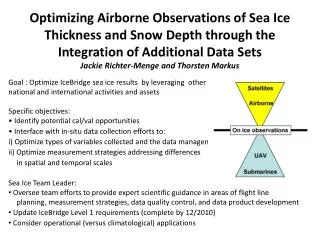
Science Team Ice Sheets and Glaciers Sea Ice Jackie Richter-Menge (CRREL, co-chair) Ron Kwok (JPL) Ron Lindsay (UW, APL) Sinead Farrell (NOAA, UMBC) Dave McAdoo (NOAA)Website:Level 1 Science Requirements, project documentation, telecon minutes, planning documents, deployment plans, etc. Ken Jezek (OSU co-chair) Robin Bell (LDEO) Bea Csatho (SUNY) Scott Luthcke (NASA/GSFC) Eric Larour (JPL) Ian Joughin (UW, APL) Mark Fahnestock (UAF) Eric Rignot (UCI/JPL) Ben Smith (UW, APL) Duncan Young (UTIG) Sophie Nowicki (NASA/GSFC) http://bprc.osu.edu/rsl/IST/ or http://www.nasa.gov/icebridge
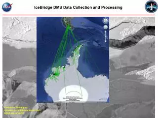
Platform and Instrument Suite Northern Hemisphere Southern Hemisphere • Wallops P-3B (Arctic Ocean & Greenland) • 2 ATM laser altimeters (NASA/GSFC/WFF) • MCoRDS radar sounder (CReSIS/KU) • Accumulation radar (CReSIS/KU) • Snow radar (CReSIS/KU) • Ku-band radar altimeter (CReSIS/KU) • Digital Mapping System (NASA/Ames) • Gravimeter (Sander Geophysics/CU) • Magnetometer (Sander Geophysics/CU) • Dryden DC-8 (S Ocean & Antarctica) • 2 ATM laser altimeters (NASA/GSFC/WFF) • MCoRDS radar sounder (CReSIS/KU) • Snow radar (CReSIS/KU) • Ku-band radar altimeter (CReSIS/KU) • Digital Mapping System (NASA/Ames) • Gravimeter (Sander Geophysics/CU) • Onboard data system (NSERC/UND) • Langley B-200 (southern Greenland) • LVIS laser altimeter (NASA/GSFC) • NSF/NCAR G-V (Antarctica) • LVIS laser altimeter (NASA/GSFC) • UAF DHC-3 (Southeast Alaska) • Riegl laser altimeter (UAF) • WISE radar sounders (NASA/JPL) • ICECAP/UTIG DC-3/BT-67 (Antarctica) • Riegl laser profiler (UTIG) • Photon counting laser scanner (Sigma Space) • HiCARS radar depth sounder (UTIG) • BGM-3 gravimeter (UTIG) • Magnetometer (UTIG) Total of 6 aircraft and 16 science instruments
largest external structureever flown on a P-3 • designed, built, and installedin only 3 months
Next Phase of IceBridge Ikhana and Global Hawk
IceBridge is imaging Ice Sheets in unprecedented detailGreenland 2011: CryoSat-2 underflight, March 29 MCoRDS Radar Quick Look Image ice surface internal layers folding bedrock
IceBridge is imaging Ice Sheets in unprecedented detail Greenland 2011: CryoSat-2 underflight, March 29 Snow radar (left) and Ku-band radar (right) Quick Look Images ice surface ice surface internal layers ice surface ice surface internal layers
IceBridge is imaging ice sheets in unprecedented detail unique 15 element antenna array for radar imaging on P-3 allows for SAR mapping of bedrock below the glacier High-resolution (500 m) Survey of Russell Glacier, Greenland to produce bedrock elevation forimproved ice sheet models Data: John Paden, CReSIS
IceBridge and the Research Community • IceBridge seeks the involvement of the broad research community to: • Use IceBridge data to measure and understand current changes in ice thickness • Incorporate IceBridge data into predictive models of changing ice cover • Use IceBridge data to improve and enhance the ICESat data set, the developing CryoSat-2 data set and the planned ICESat-2 data set • In addition, we seek community contributions that: • Vet the scientific accuracy and usability of IceBridge data and data products • Develop new techniques and algorithms necessary to address IceBridge Projected Science Requirements:http://bprc.osu.edu/rsl/IST/
Operation IceBridge Operation IceBridge: http://www.nasa.gov/icebridge Science Team: http://bprc.osu.edu/rsl/IST/ Data is available atNational Snow and Ice Data Center (NSIDC) http://nsidc.org/data/icebridge/ No period of exclusivity! Flight planning tool: http://icebridge.sr.unh.edu/icebridge/ant/
OIB Land Ice Phase 3-4 Strategy • Phase 1 (2008-2010): OIB demonstrated successful, spatially extensive data collections in both the Arctic and Antarctic • Phase 2 (2010-11): Rigorous science requirements adopted for planning and mission success analysis • Phase 3 (2012 – 2015) • Vet data for utility for solving science problems; • increase spatial and temporal coverage (UAVs); • Adopt advanced technologies (e.g. tomography); • develop an end-to-end vision that emphasizes rapid model/process output for resolution of key science questions • Phase 4 (2015-2020) • Acquire I-2 prelaunch data to assure quick continuity of dh/dt record • One post launch campaign in Arctic and Antarctic to assure continuity • Continued focused missions that • Utilize flexibility of airborne platforms • Combine in situ, airborne and spaceborne observation to increase confidence in interpretation • Maintain crucial instruments that are still unique to airborne platforms • Respond to unique, transient geophysical phenomena • http://bprc.osu.edu/rsl/IST/index_files/PROJECTDOCUMENTS.htm Tomographic image of Russel Glacier Courtesy of JPL, KU and OSU. Image compilation of 2011 Pine Island Glacier rift courtesy of M. Studinger.
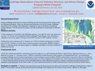
IceBridge Sea Ice Team Recent and current activities • Evaluation of sea ice thickness Value Added Products • Components: • Sea Surface Height • Lead masking • Freeboard • Snow depth • Ice thickness • Sound scientific approach • Clear and adequate documentation outlining procedure • Flight lines recommendations • Increased coverage in Chukchi/Beaufort Seas • Challenge: Fairbanks temporary base of operations Ongoing Ongoing
Value Added Product Instrument Products DMS (Lead Detection) Sea Surface Height Sea Ice Freeboard ATM (Air/Snow Interface Elevation) Sea Ice Thickness Snow Depth Ku Band Radar (Snow/Ice Interface Elevation) Snow and sea ice density Lead Detection Snow Radar (Snow Depth) Airborne measurement of sea ice thickness is a derived, versus direct, product
IceBridge Sea Ice Team Recent and current activities • Evaluation of sea ice thickness Value Added Products • Components: • Sea Surface Height • Lead masking • Freeboard • Snow depth • Ice thickness • Sound scientific approach • Clear and adequate documentation outlining procedure • Flight lines recommendations • Increased coverage in Chukchi/Beaufort Seas • Challenge: Fairbanks temporary base of operations Ongoing Ongoing