IceBridge DMS Data Collection and Processing
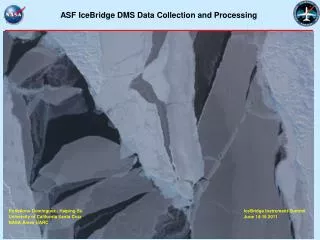
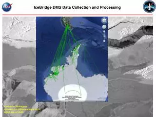
IceBridge DMS Data Collection and Processing. RoseAnne Dominguez University of California Santa Cruz NASA Ames UARC. OIB DMS Data Processing Status. Airborne Science Program Facility Instrument (as of 2010) 21 megapixel camera, 28mm lens 1.966 TB data collected (229,000 frames)

IceBridge DMS Data Collection and Processing
E N D
Presentation Transcript
IceBridge DMS Data Collection and Processing RoseAnne Dominguez University of California Santa Cruz NASA Ames UARC
OIB DMS Data Processing Status • Airborne Science Program Facility Instrument (as of 2010) • 21 megapixel camera, 28mm lens • 1.966 TB data collected (229,000 frames) • 2m resolution @ 34,000’ (5.0 sec frame interval) • 10cm resolution @ 1600’ (1.3 sec frame interval) • 12,720 frames processed to date (5%) • Processed format JPG/JGW Note: NOT USGS-quality • Projection: Geographic Lat/Long (WGS84 Datum) • 3-D ray trace software completed • Full bore-sight correction to be implemented • Archive plan: NASA ARC + NSIDC servers (TBD); Google Earth visualization tool; web download interface (SGGATE-ARC)
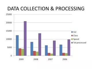
Registration Software (completed) Software Development (visualization and data distribution) Data Processing DMS Processing Timeline
DMS Visualization • Google Earth Visualization • Aircraft Flight Track • Frame ID • Frame Reference Data • Thumbnail image display • Web based Data Distribution • Access to geo-registered or raw data (if desired) • Query options • Date / time • Location • Map Interface • Frame ID
Punta Arenas Airport • Preliminary Error Analysis • X -5.7m* Dvs GE • Y 9.0m* • Note(s): • Boresight not implemented • Low resolution DEM • *Lever Arm measurement error • Accuracy Goal (1500’ / 35000’) • X-Y 0.5m / 5m • Dependent on DEM resolution, bore-sight quality and IMU capability
Weddell Sea Ice Mosaic DMS Three Frame Mosaic 30 October2009 Full Resolution