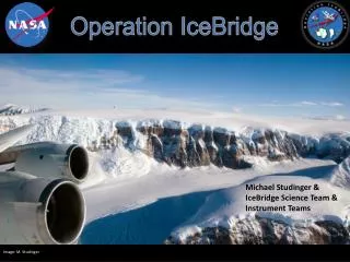
Overview of NASA's IceBridge Program and Its Goals for Arctic and Antarctic Research
The IceBridge Program aims to enhance understanding of polar ice dynamics through airborne altimetry and remote sensing. Its first phase involves making critical measurements over ice sheets and sea ice, extending records initiated by ICESat. The program links data from ICESat, ICESat-2, and CryoSat-2 to create a comprehensive ice altimetry record. By monitoring changing ice areas, it seeks to improve predictive models of sea level rise and ice cover. Additionally, the program collects geophysical data to refine estimates of heat flux affecting glaciers, essential for future climate assessments.

Overview of NASA's IceBridge Program and Its Goals for Arctic and Antarctic Research
E N D
Presentation Transcript
IceBridge Program Overview Tom Wagner IceBridge Program Scientist
Program Goals The first phase of IceBridge will include the following: • Making airborne altimetry measurements over the ice sheets and sea ice to extend the record of observations begun by ICESat. • Linking the measurements made by ICESat, ICESat-2, and CryoSat-2 to allow accurate comparison and production of a long-term, ice altimetry record. • Using airborne altimetry to monitor key, rapidly changing areas of ice in the Arctic and Antarctic to maintain a long term observation record, improve understanding of glacial dynamics, and improve predictive models of sea level rise and sea ice cover. • In conjunction with altimetry measurements, collecting other remotely sensed data to improve predictive models of sea level rise and sea ice cover, especially the following: • Ice thickness and structure; • Bed topography underlying land-based ice; • Bathymetry beneath floating ice shelves; • Snow accumulation and firn structure; and • Other geophysical constraints that will improve estimates of the geothermal and oceanic heat flux. • Monitoring important areas of sea ice for understanding present and future changes in sea ice cover and thickness. • Adapting existing instruments for airborne remote sensing of ice by unmanned aerial systems such as NASA’s Global Hawk.
Science Team ResponsibilitiesIceBridge ROSES 1) Final development of the IceBridge Science Definition Document and Level-1 Scientific Requirements Document; 2) Evaluation of the IceBridge mission designs in achieving the goals defined by the Science Definition Document and Level-1 Scientific Requirements Document as requested by the NASA Program Scientist; and 3) Support to the IceBridge Program Scientist and Project Scientist in the development of the required analyses, documentation, and reporting during the IceBridge mission.