Understanding Base Flood Elevation Determination in Approximate A Zones
This unit provides essential knowledge on determining Base Flood Elevations (BFEs) in Approximate A Zones. Learn to identify potential data sources, contour interpolation, and data extrapolation techniques for estimating BFEs when detailed studies are unavailable. Additionally, you will explore the purposes of letters of map change and common errors in application forms. Simplified and detailed estimation methods will be covered, ensuring a comprehensive understanding of floodplain geometry, hydrology, and hydraulics relevant to flood hazard mapping.

Understanding Base Flood Elevation Determination in Approximate A Zones
E N D
Presentation Transcript
Objectives • At the end of this unit, you should be able to: • List potential data sources for determining BFEs in Approximate A Zones. • Describe contour interpolation and data extrapolation techniques used to determine BFEs.
Objectives (Continued) • At the end of this unit, you should be able to: • Identify the purposes of letters of map change. • Identify forms needed to apply for different types of map changes. • Describe errors commonly found on map change application forms.
Approximate A Zone Elevations • Detailed studies are not available. • Simplified methods can provide estimated BFEs. • If you lack confidence in simplified estimation methods, require property owners to provide BFEs based on detailed studies.
Simplified and Detailed Methods • Simplified methods: • Contour interpolation • Data extrapolation (rarely applicable) • Culvert hydraulics • Detailed methods: • Floodplain geometry (topography) • Flood frequency—Discharge (hydrology) • Flood discharge—Stage (hydraulics)
Contour Interpolation and Data Extrapolation • Both are simplified methods, and cannot be used to support LOMA and LOMR-F applications. • Contour interpolation overlays topographic maps on the FIRM. • Data extrapolation extends flood profiles beyond the detailed study area. • At least one other method plus previous flooding history should be used.
Contour Interpolation • Obtain a topographic map of the site. • Reduce/enlarge to FIRM scale. • Overlay Zone A floodplain boundary on the topographic map. • Does floodplain boundary follow contour lines within acceptable limits? (Elevations of left and right overbanks must be within one-half of the contour interval of the map.) • If accuracy is acceptable, determine the BFE.
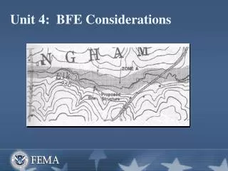
FIRM + Topographic Map (Figure 8) FEMA 265, page V-4, description page V-3, Example 1Pages 4-11 and 4-12 in your Participant Manual
In-class activity Interpreting Figure 8 • Find Example 1 paragraph on page V-3 (page 4-11 in your Participant Manual). • What is the contour interval of Figure 8? • At the structure site, what is the elevation of the left (upper) bank on the map? • What does the map show as the elevation of the right (lower) bank? • How many feet = ½ of the contour interval? • Is the method acceptable at this site? • What is the estimated BFE?
FIRM + Topographic Map (Figure 9) FEMA 265, page V-5, description page V-4, Example 2 Pages 4-12 and 4-13 in your Participant Manual
In-class activity Interpreting Figure 9 • Find Example 2 paragraph on page V-4 (page 4-12 in your Participant Manual). • What is the contour interval of Figure 9? • At the structure site, what is the elevation of the left (upper) bank on the map? • What does the map show as the elevation of the right (lower) bank? • How many feet = ½ of the contour interval? • Is the method acceptable at this site?
Data Extrapolation Criteria • Site must: • Be within 500 feet of the detailed study area. • Have floodplain characteristics similar to the detailed study area—for example: • The valley does not narrow rapidly upstream. • There is no waterfall. • Have no hydraulic structures such as dams and bridges.
Data Extrapolation Steps • Determine the location of the site on the flood profile for the detailed study area. • Extrapolate the last segment of the flood profile that has a constant slope to the location of the site. • Determine the BFE from the extrapolated profile.
Detailed Methods • Three key elements: • Floodplain geometry (topography) • Flood frequency—Discharge (hydrology) • Flood discharge—Stage (hydraulics)
Sta. 0 Elev. 500 Sta.4000 Elev. 510 Sta. 1100 Elev. 475 Sta. 3100 Elev. 475 Sta. 2100 Elev. 475 Sta. 2600 Elev. 450 Topography • Geometry of cross-section of the floodplain • Vertical coordinates (elevation) • Topographic maps • Field-surveyed cross-sections • Increased level of detail on topographic map = increased accuracy of floodplain delineation
Hydrology and Hydraulics • Hydrology gauges peak rate of stream flow during a flood throughout a watershed. • Hydraulics predicts water surface elevations that occur at a particular site during a flood. • QUICK-2 is a software program that performs hydraulic calculations.
In-class activity Activity: Zone A Data Sources • Purpose: Determine appropriate sources for existing data in unnumbered A Zones. • Work with others in your group to resolve each of the following questions or situations. • You may use the Flood Data Sources table that follows the questions as a resource.
Letters of Map Change Procedures • Not enough funding to map all with detailed methods • Two types of analysis done: • Detailed analysis (developed and developing areas) • Approximate analysis (undeveloped areas)
In-class activity Activity: Map Change Acronyms • Purpose: Ensure that you understand the meaning of some map-related acronyms. • Work with others at your table to write the words represented by each acronym. • Then choose a definition from the choices listed. Write the letter of the definition in the space to the left of the acronym. • You may use the course glossary as a reference.
Map Change Letters From FEMA • LOMA (MT-1 surveyor) • C-LOMR-F (MT-1 surveyor) • LOMR-F (MT-1 surveyor) • C-LOMR (MT-2 engineer) • LOMR (MT-2 engineer)
Map Change Letters From FEMA • Who receives the map change letter from FEMA? • What is the difference between a LOMR and a LOMR-F?
Remember . . . • LOMA and LOMR-F applications require detailed methods of estimating BFEs.
Map Change Process • Community endorsement of the map change process is very important. • For any map change letter other than a LOMA, a local official must sign the request.
In-class activity MT Forms • Refer to the MT forms in the Forms Appendix in the back of your Participant Manual.
Map Change Request Forms • MT-EZ: Single lot/existing structure, no fill, no change to BFE or floodway (LOMA) • MT-1: Single or multiple lots/structures, proposed structures or fill, no change to BFE (LOMA, CLOMA, LOMR-F, CLOMR-F) • MT-2: Series of 12 forms to request a LOMR
Submittal Documents • Copy of recorded deed • Tax Assessor’s Map • Certified Site Plan/Boundary Survey • Copy of the effective FIRM • FIRM with property accurately plotted • FIS Flood Profile • Signed/Dated Property Information Form • Elevation Certificate
In-class activity MT-1 Sample Submittal Documents • Refer to the MT-1 forms in the Forms Appendix. • Locate each of the forms listed on the previous visual. • Pages 4-52 through 4-58 in your Participant Manual show examples of forms for an MT-1 submittal.
Generic Problems: MT Forms • All forms not submitted • Forms not completed • Confusion about definitions • Lowest Adjacent Grade • Lowest Floor Elevation • Lowest Lot Elevation • Only lowest floor elevation submitted
Generic Problems: MT Forms (Cont.) • Applicant request for the lot only, not for the actual/planned structure • Recordation data missing from deed or plat • Plat or tax map insufficient to locate property on FIRM • Plat not certified
Required Fees • LOMA—Fee exempt • All others—Fees required • Check the Web site for current fees: • http://www.fema.gov/fhm/frm_fees.shtm