Objectives
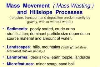
Mass Movement ( Mass Wasting ) and Hillslope Processes ( erosion, transport, and deposition predominantly by gravity, with or without water ). Sediments : poorly sorted, crude or no stratification; dominant particle size depends on source material and amount of water.

Objectives
E N D
Presentation Transcript
Mass Movement ( Mass Wasting ) and Hillslope Processes( erosion, transport, and deposition predominantly by gravity, with or without water ) • Sediments: poorly sorted, crude or no stratification; dominant particle size depends on source material and amount of water. • Landscapes: hills, mountains (“setting”, not Mass Movement features per say ) • Landforms: debris flow, earth topple, landslide • Microfeatures: minor scarp, sand boil
Objectives The participant will be able to: • Identify mass wasting processes, Landscapes, Landforms, Microfeatures, and associated Parent Materials. • Diagram cross-sections, (topography, stratigraphy, soil hydrology and pedology) typical for mass wasting sequences. • Successfully complete quizzes / exercises • Actively apply gained knowledge on field trips.
Mass Movement ( Mass Wasting ) Erosion main scarp minor scarp ( voids , modified features ) Transport avalanche chute talus slope terracettes ( dynamic deposits and landforms ) Deposition solifluction lobe slump block landslide deposits ( stable deposits and landforms )
Landslide Incidence Low (< 1.5 % of area involved) Moderate (1.5 – 15% of area involved) High (> 15% of area involved) Landslide Potential Landslide Susceptibility/Incidence Moderate susceptibility / low incidence High Susceptibility / low Incidence High Susceptibility / moderate incidence http://landslides.usgs.gov/learning/nationalmap/legend.php USGS National Atlas.com.esri.esrimap
Mass Movement ( Mass Wasting ) • Many arrays, naming conventions (e.g. material, speed, type of mechanical deformation, etc.). • NRCS - Soil Survey uses National Research Council - Transportation Research Board (TRB Special Report - # 247) as the primary source. • NRCS (NASIS, Field Book, GDS) uses a matrix based upon type of movement and dominant material.
Landslide Categories - NCSS, TRB ( dominant type of movement ) 1) Fall 2) Topple 3) Slide (2 subtypes) 4) Spread 5) Flow 6) Complex Landslide - modified from Varnes (1958, 1978)
GSC # 2002-585 Landform: rotational debris slide, slump blocks Microfeatures: main scarp, minor scarp, toe PM: glaciolacustrine sediments Ft. St John, BC, CAN
Dena Marshall Microfeature: crown ( landslide crown cracks ) Lawrence Co., IN
Schoeneberger Landscape: plateau, intermontane valley Landform: escarpment, landslides, valley floor Black Mesa, AZ
Schoeneberger Landscape: plateau Landforms: escarpment,rotational slide, slump blocks, Toreva blocks Black Mesa, AZ
Schoeneberger Detail: mini-mudflow on a cutbank Lincoln, NE
Landslide Identification • Identify landslides to the maximum extent (detail) possible. • Example: landslide( most generic ) rotational slide ( identifies dominant type of movement ) rotational debris slide(adds dominant material )
8. MASS MOVEMENT( dominated by gravity, includes creep ) Landscapes : ( not mass movement features per say, but common habitat ). breaklands BR hills HI dissected breaklands DBR mountain range MR etc. etc. Landforms : ash flow ASrock spread ROS avalanche chute ALrock topple ROT block glide BGrotational debris slide RDA block stream BX rotational earth slide RES complex landslide CLSrotational rock slide RRS debris avalanche DArotational slide RTS debris fall DEFsag ( also Microfeature )SAG debris flow DFsag pond ( water body, also Micro. )SGP etc.etc. Microfeatures : main scarpMASsolifluction lobe SOL minor scarpMIS solifluction sheet SS etc. etc.
Schoeneberger Landforms: rock fall, escarpment,beveled baseEscalante Natl. Monument, UT
GSC # 2001-069 Landform: rock topple (note new fracture paralleling cliff-face)northwestern Manitoba, CAN
Schoeneberger Landform: small rotational landslide, main scarp, toeLincoln, NE
Landform: translational rock slide ( slip face ) PM: sloping, interbedded sed. Rocks western MT Schoeneberger
(GSC2002-203) Landform: spread (glacial delta sands over marine muds)Labrador, CAN
lateral displacement of intact blocks, “floating” on plastic flow
( Michael Collier AGI iejhw1 ) Landscape: dunefield Landform: dune Microfeatures: sand flows on a slipface; sand ripplesCoral Pink Dunes Park, UT
GSC # 2002-594 Landscape: mountains Landform: complex landslide (translational rock slide, rock avalanche), avalanche chutes, U-shaped valleys Brazeau Lake Valley, Jasper Natl. Park, CAN
Pop Quiz: Name the features ( start general, get specific ). ?? (seeps in loess over basalt) Palouse, WA
Eroded hillslopes, vs. mass wasting ? Schoeneberger Landforms: escarpment, complex landslide, slump blocks; Beautiful Valley, AZ
GSC # 2002-584 Landform: debris flow(mudflow?, complex landslide?);1999; 5-mile Ck, Banff Natl. Pk., Alberta, CAN
Univ. of WY Landforms: alluvial fan, debris flow PM: alluvium, debris flow deposits Badwateralluvial fan
Schoeneberger Landscapes: plateau, intermontane valley Landforms: cliff, ledge, structural bench, landslideBlack Mesa, AZ
Wysocki Landscape: mountain range Landforms: landslides, avalanche chute, U-shaped valleyCascades Range, WA
pt: logged 4 years earlier Schoeneberger Landscape: mountain range Landforms: landslides, avalanche chutes,U-shaped valley( trimline, logging, roads )Cascades Range, WA
Wysocki Landscape: hills Landform: complex landslide (rotational debris slide / spread) Microfeature: main scarpID
Wysocki Parent Material: sloping sedimentary rocks: Tertiary (Pliocene?) lacustrine deposit (silts / clays; landslide base)ID
Wysocki Landforms: rotational slide, slump blocks Microfeatures: toe, sagID
Wysocki Landform: rotational slide, topple Microfeatures: slump blocks, main scarp, minor scarpsID
Wysocki Landform: landslide Microfeatures: main scarp, toe, slump blockID
Wysocki Landform: complex landslide Microfeatures: slump blocks, sags, main scarpJphn Day FmOR
Wysocki Landform: lahar(volcaniclastic mudflow / debris flow) Parent Material : laharMT St. Helens, WA
Lahar ( volcanic mudflow ) hazards potential : Mt Rainer, WA Hoblitt and others 1998; USGS Open File Report 98-428
stylized graphic A: hillslope (typical example for nearly level-bedded sedimentary bedrock)
stylized graphic B: possible hillslope map units based on parent material and geomorphic position
Schoeneberger soil creep( f & m prismatic soil structure; 10-20 cm diam., 60 cm length; 27 % slope) Komodo Is., Indonesia
Schoeneberger Mass Movement : creep (indicated by pistol-butt tree trunks)Gifford-Pinchot Natl. Forest, WA
Schoeneberger Landscape: river valley(Rio Grande R.) Landforms: Toreva blocks, cliff White Rock, NM
Schoeneberger Landscape: river valley(Rio Grande R.) Landforms: Toreva blocks, cliff White Rock, NM
Landform: avalanche chute ( note: little veg.; no drainage channel ) Madison R. Canyon, MT Schoeneberger