Download
1 / 1
10 likes | 124 Views
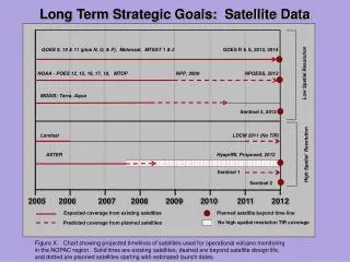
Explore the long-term strategic goals and projected timelines of satellites for operational volcano monitoring in the NOPAC region. Includes existing, planned, and proposed satellites, their launch dates, and coverage resolutions.

E N D
Long Term Strategic Goals: Satellite Data GOES 9, 10 & 11 (plus N, O, & P), Meteosat, MTSAT 1 & 2 GOES R & S, 2012, 2014 Low Spatial Resolution NOAA - POES 12, 15, 16, 17, 18, MTOP NPP, 2009 NPOESS, 2012 MODIS: Terra, Aqua Sentinel 3, 2013 Landsat LDCM 2011 (No TIR) ASTER HysprIRI, Proposed, 2012 High Spatial Resolution Sentinel 1 Sentinel 2 2005 2006 2007 2008 2009 2010 2011 2012 Expected coverage from existing satellites Planned satellite beyond time line No high spatial resolution TIR coverage Predicted coverage from planned satellites Figure X. Chart showing projected timelines of satellites used for operational volcano monitoring in the NOPAC region. Solid lines are existing satellites, dashed are beyond satellite design life, and dotted are planned satellites starting with estimated launch dates.