Download
1 / 12
120 likes | 261 Views
Discover how to navigate the Indiana Interactive Traffic Flow Map, presented by Greg Katter, PE. Start by visiting www.in.gov/indot and expanding the “Resources” menu to select “Traffic Statistics.” Understand how to view valuable data and utilize the map effectively. The map features color-coded traffic zones, state routes with traffic volumes, and tools for searching by county, city, or station ID. For further assistance, contact Autumn Young or Greg Katter via their provided emails.

E N D
Accessing Indiana Traffic Data Presented by: Greg Katter, PE Long Range Planning and Modeling
Indiana Interactive Traffic Flow Map • Accessing the Map Start at www.in.gov/indot
Indiana Interactive Traffic Flow Map In the list on the right, expand the “Resources” menu and select “Traffic Statistics”
Indiana Interactive Traffic Flow Map After becoming familiar with the description of the the INDOT Traffic Statistics Section, click on “Interactive Traffic Flow Map” to open the map
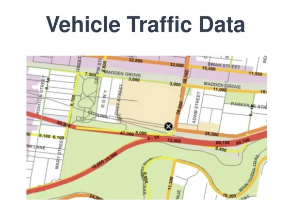
Indiana Interactive Traffic Flow Map This will bring up the Interactive Traffic Flow Map.
Indiana Interactive Traffic Flow Map • To the right of the map are three tabs. Each contains valuable information about how the data on the map is derived and displayed and should be reviewed prior to use of any data obtained from the map. The tabs are • Information • Instructions • Search Tools
Indiana Interactive Traffic Flow Map • Legend • Traffic Zones are color coded by traffic volume • State owned and maintained routes are labeled with their Route Name, AADT and daily volume of commercial vehicles • At closer zoom scales, the locations where counts were collected are displayed.
Indiana Interactive Traffic Flow Map Search Tools By using the pull down menus, one can select a County, City or Route that can be zoomed to by clicking the “Go” button A Count Station number can be zoomed to by typing the Count Station number into the “Enter a Station ID” box and clicking on the “Go” button
Indiana Interactive Traffic Flow Map Search Tools The radio buttons can be used to display different sets of data Links are included to access maps of older data and documents describing the various factors that are used to develop the data in the map. A link offers the opportunity to download the traffic data in a Shape file.
Indiana Interactive Traffic Flow Map Map Features Clicking on a Route segments opens a bubble with information about that segment.
Indiana Interactive Traffic Flow Map Map Features Clicking on a Count Station opens a bubble with information about that Station and includes links to download reports of the data collected at the site, where available.
Questions Contacts: Autumn Young, Manager Traffic Statistics Supervisor Email: Ayoung@indot.in.gov Greg Katter, PE Long Range Planning, Modeling and Forecasting Section Email: Gkatter@indot.in.gov