Download

1 / 10
110 likes | 313 Views
Physical Geography of Canada. Great Lakes- St.Lawrence Lowlands. Smallest geographical region Humid continental climate Vegetation: fertile soils, heavily treed, maple, beech, hickory, black walnut trees, oak, ash, birch, and pine

E N D
Great Lakes-St.Lawrence Lowlands • Smallest geographical region • Humid continental climate • Vegetation: fertile soils, heavily treed, maple, beech, hickory, black walnut trees, oak, ash, birch, and pine • Environmental concerns: acid rain, pollution of the Great Lakes • Topography: rolling landscapes
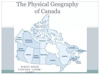
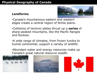
Canadian Shield • More than 2 billion years old • Humid continental climate • Vegetation: spruce, pine, fir, polar and white birch, and sandy soil • Environmental concern: extraction and use of resources and timber • Topography: glaciers removed soil • Barren rock surface in many places
Interior Plains • Vast sweep of plain • Not entirely flat • Rolling hills and deep river valleys • Continental climate • Northern portion has arctic climate • Long, cold winters and short, cool summers • Vegetation: trees grew in river valleys • Environmental concern: tornadoes • Topography: devided into central lowlands and great plains
Intermountain Region • Locates between Rocky and Coast mountains • High plateaus • Isolated mountains • Climate: affected by its location and elevation • Environmental concern: birds habitats being destroyed, 11 bird species are endangered • Topography: streams and rivers never reach the sea
Arctic Plains • Northern Canada • Combination of lowlands and mountains • Climate: very severe, winter lasts for 10 months and very cold and dry • Vegetation: very few plants can grow • Trees can’t grow on the tundra • Topography: flat Arctic near the ocean
Appalachian Region • Mountainous area • Extends for 2400 km • Climate: varies throughout the yearand affected by 2 ocean currents • Vegetation: heavily forested with coniferous and deciduous trees • Soil was productive • Topography: mountains were formed 300000000 years ago • Not wholly mountainous • Contains fertile plateaus and river valleys
Coastal Plains • Lowland area • Climate: subject to hurricanes between late summer and early winter • Vegetation: soils are very sandy • Pine forests • Lush jungles • Environmental concern: hurricanes • Topography: mostly flat or gently rolling surfaces • Many swamps and marshes
Western Cordillera • Rocky Mountains • Separated by plateaus and valleys • Climate: maritime climate • Vegetation: grasses and cactuses grow in dray valleys • Great evergreens no longer grow • Giant sequoia, the largest tree, grows • Topography: comprised of new mountains not yet worn down by erosion