Download
1 / 1
10 likes | 103 Views
Explore and identify ideal property locations for single-family homes in the designated study area of Cleveland Ward 18. Find parcels meeting specific criteria such as size, zoning, proximity to amenities like RTA rail stops, and elevation restrictions. Analyze population patterns within 1000 feet of rail stops and ensure parcels are outside floodplain areas. Utilize GIS data and spatial analysis to select parcels that adhere to all outlined requirements.

E N D
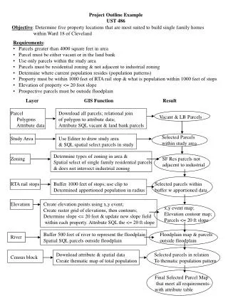
Project Outline Example UST 486 Objective: Determine five property locations that are most suited to build single family homes within Ward 18 of Cleveland • Requirements: • Parcels greater than 4000 square feet in area • Parcel must be either vacant or in the land bank • Use only parcels within the study area • Parcels must be residential zoning & not adjacent to industrial zoning • Determine where current population resides (population patterns) • Property must be within 1000 feet of RTA rail stop & what is population within 1000 feet of stops • Elevation of property <= 20 foot slope • Prospective parcels must be outside floodplain Layer GIS Function Result Parcel Polygons Attribute data Download all parcels; relational join of polygon to attribute data; Attribute SQL vacant & land bank parcels Vacant & LB Parcels Selected Parcels within study area Study Area Use Editor to draw study area & SQL spatial select parcels in study Determine types of zoning in area & Spatial select of single family residential parcels & does not intersect industrial zoning Zoning SF Res parcels not adjacent to industrial RTA rail stops Buffer 1000 feet of stops; use clip to Determined apportioned population in radius Selected parcels within buffer w apportioned data Elevation Create elevation points using x,y event; Create raster grid of elevations, then contours; Determine slope <= 20 feet & update new slope field within each property. Attribute SQL the <= 20 ft slope x,y event map; Elevation contour map; Parcels <= 20 ft slope Buffer 500 feet of river to represent the floodplain Spatial SQL parcels outside floodplain Floodplain map & parcels outside floodplain River Download attribute & spatial data Create thematic map of total population Selected parcels in relation To thematic population pattern Census block Final Selected Parcel Map that meet all requirements- with attribute table