Understanding Earth's Rotation, Revolution, and GPS Navigation
Explore the fundamental concepts of Earth's rotation and revolution, and their effects on day-night cycles and seasons. This lesson covers how Earth spins on its axis (every 24 hours) and revolves around the Sun (every 365 days), impacting temperature and biodiversity. Additionally, learn about latitude and longitude coordinates, how GPS works, and its connection to mapping systems. Engage in activities to apply these concepts, including locating countries using coordinates and understanding hemispheres.

Understanding Earth's Rotation, Revolution, and GPS Navigation
E N D
Presentation Transcript
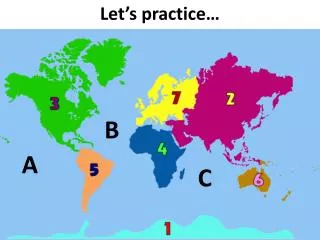
Let’s practice… B A C
What is meant by Earth’s rotation? What is meant by the revolution of Earth?How does this affect our day and a year?
What is meant by Earth’s rotation? *spinning on it’s axis (every 24 hours)What is meant by the revolution of Earth? * full trip around the sun on the orbit (365 days)Effects:*Daytime/Night (length of each, temperature differential) *Seasons (temperature, precipitation, biodiversity)
Front of circle is 1800 Back of circle is + 1800 Full circle is 3600 Hemispheres (hemi- means ½) 90* N 90* W + + 90* S 90* S 180* (+ 1800 backside of this image) = 3600 ,wwwwwwwwwww 1800 (+ 1800 backside of this image) = 3600
? (runs East/West) ? (runs North/South)
LATITUDE (runs East/West) LONGITUDE (runs North/South)
Before the end of class you should be able to…. Locate the a country given the degrees of latitude and longitude Explain how GPS (the mapping system in your phone or car) relates to this topic and how it works. Please take Cornell Notesduring the presentation!
What is GPS? How does it work? What do lines of latitude and longitude have to do with it?
Let’s INFER before I EXPLAIN how GPS works…. This is the guy who just ran off with your cell phone (it’s being tracked).
Each GPS satellite transmits data that indicates its location and the current time to receivers that passively receive the signals. All GPS satellites synchronize operations so that these repeating signals are transmitted at the same instant. The signals, moving at the speed of light, arrive at a GPS receiver at slightly different times because some satellites are farther away than others. The distance to the GPS satellites can be determined by estimating the amount of time it takes for their signals to reach the receiver. When the receiver estimates the distance to at least four GPS satellites, it can calculate its position in three dimensions.There are at least 24 operational GPS satellites at all times. The satellites, operated by the U.S. Air Force, orbit with a period of 12 hours. Ground stations are used to precisely track each satellite's orbit. A GPS receiver "knows" the location of the satellites, because that information is included in satellite transmissions. By estimating how far away a satellite is, the receiver also "knows" it is located somewhere on the surface of an imaginary sphere centered at the satellite. It then determines the sizes of several spheres, one for each satellite. The receiver is located where these spheres intersect.Retrieved from http://www.nasm.si.edu/gps/work.html
The relationship between these units resemble time. By general standards, 1 degree latitude equals 69 miles, 1 degree longitude equals 42 miles. 1 minute latitude is equivalent to 6072 feet and 1 minute longitude equates to 3696 feet. 1 second equates to 101.2 feet, 1 second longitude equals 61.6 feet. This GPS device gives coordinates which refer to a location that is more than 43 degrees north of the equator and a little over 80 degrees west of the Prime Meridian. Seconds Minutes Degrees
Before we begin the activity, please pay close attention to the following slides.
5 Components of a Map: Title Grid system (latitude and longitude) Scale compass rose Legend ("Key" )
Directions • The cardinal directions are north, south, east, and west. • The intermediate directions are northeast, southeast, southwest and northwest. • They help describe the location of places in relation to other places.
What is the latitude/longitude of Detroit? • Latitude 1st… find the dot & run finger up to margin. • Document the latitude in degrees w/quadrant. • Longitude is written second. Find location dot and run it to the margin. • Document the longitude in degrees w/quadrant.
What state is located at 40*N90*W? Illinois
What Quadrant? ? ? ? ?
What Quadrant? NW NE SW SE
Exit Ticket (as a group)…. Latitude runs _________, while longitude runs _________ How many hemispheres? In which hemisphere is South America? Name one country through which the Prime Meridian runs. What is GPS ? How does it work? How is it related to longitude and latitude?