Celestial Navigation
Celestial Navigation. Theory, Navigational Astronomy, The Practice R. Bruce Jones February 17, 2014. What is the theory?. The basic theory behind Celestial Navigation is that we find our unknown position from a known position. If we have some information we can deduce the rest.

Celestial Navigation
E N D
Presentation Transcript
Celestial Navigation Theory, Navigational Astronomy, The Practice R. Bruce Jones February 17, 2014
What is the theory? • The basic theory behind Celestial Navigation is that we find our unknown position from a known position. • If we have some information we can deduce the rest.
Find the sun • Imagine the sun is directly overhead at a particular time. • Look in the Nautical Almanac to find out where the sun is. • That is where we are!
How do we know? • How do we know that the sun is directly overhead? • The sextant tells us. • It measures the angle form the horizon. • In this case the angle would be 90°
BUT!, The sun is not overhead! • But what if the sun were 1° from overhead (sextant reads 89°)? • Then we would be somewhere on a circle 60 miles (60 nm= 1°) from where the Nautical Almanac said the sun was. • This is a circular line of position (LOP).
Actual Position • An actual position occurs where two lines of position (LOP’s) cross. • For example: your plotted track on a chart intersects a circular LOP.
Second LOP • If we look at the sun later in the day, we would get a second circle. • Our position would be at one of the intersections of the two circles. • If you still do not know your position, do a third sight to get a third circle.
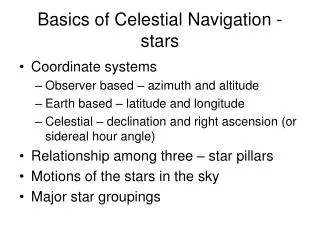
Navigational Astronomy Just four things to remember!
#1 Ptolemy was right! • Celestial navigation’s view of the heavens is pre-Copernican. • We look at an earth-centric system in which the sun, moon, planets, and stars revolve around it. • It is a what you see is what you get system.
#2 Einstein was right! • Space and time are a continuum. In navigational astronomy time = distance. • Longitude is measured in degrees where 15° = 1 hour. • 360° = 24 hours = Earth’s rotation • 1 second in time = ¼ nautical mile at the equator • An error in time is an error in longitude
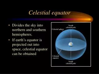
#3 The Coordinate System • Earths Coordinates • Celestial Coordinates • Observers/Horizon Coordinates • Ecliptic Coordinate
Earths Coordinates • Latitude lines running parallel to earth’s equator at 90° to 0° at the poles. • Longitude lines running around the earth thru each pole. • Longitude lines start at 0° at the Greenwich Meridian and run 180° east and west for a total of 360° • 1° = 60 minutes • 1minute = 60 seconds • 1° = 3600 seconds
Celestial Coordinates • Celestial Equator: Earth’s equator extended into space. • Declination: Earth’s latitude lines extended into space, going from the celestial equator, 90°, north and south to the celestial poles. • Hour circles: Earth’s longitude lines extended into space, this can be measured two ways. • The Sidereal Hour Angle (SHA) or right ascension angle, zero starts at the first point of Aries or vernal equinox and travel's west to 360°. If the Greenwich celestial meridian is used this measurement is called the Greenwich Hour Angle (GHA).
Observers/Horizon Coordinates • Completely dependent on observer. • You measure hs to start the process of finding your location
Ecliptic Coordinate System • The Ecliptic is the path that the sun appears to take among the stars. • Our navigational measurement of SHA start at the first point of Aries or vernal equinox.
#4 Hour Angles • It all starts with Geographic Position (GP). Imagine a string that stretches from the center of the earth to the center of the celestial body. GP is the point the line passes thru the earths surface. This point has a location that can be referenced several ways…
Hour AngleRemember time = distance • M – Observers Meridian • G – Greenwich Meridian • SHA – Angular distance of a body westward from the first point of Aries (0-360) • RA – Angular distance of body eastward from the first point of Aries: in time units (0-24 hrs.) • GHA – GP’s distance from Greenwich Meridian (Degree, Min:Sec) • LHA – GP’s distance west from the meridian you are located on (Degree, Min:Sec)
The Nautical Almanac gives us the GHA of the sun and the moon for every day, hour and minute of the year. For the stars it gives the SHA, which we can then convert, and worksheets help us figure the LHA by using our longitude.
The PracticeTaking the sight • Setting up • Shooting body and noting exact time corrected for watch error and east or west of Greenwich meridian. • Correcting for sextant error, height of eye and altitude giving Observed Altitude. • Entering body’s data for same time from the Nautical Almanac, apply corrections. • Entering tables for sight reduction with: • Local Hour Angle (LHA) • Assumed Latitude • Body's declination (from Almanac) to find the calculated height if you were where you assumed yourself to be • This will give you the CALCULATED ALTITUDE as well as the true bearing of the body
Navigational Triangle aka spherical trigonometry • For a given date and time you know. • AP - Your assumed position • GP – Celestials Bodies position • Given information that you have or can drive from tables or formulas you determine: Z- Azimuth angle and Zenith distance.
Plotting Celestial FixThere are 5 essential pieces of data for reducing a celestial sight • Observed altitude of the Body above the celestial horizon. Measure it with a sextant (hs), and then apply relevant corrections to get Ho. • Latitude and longitude of your assumed position (AP). • Precise time of the sextant altitude measurement, in order to calculate Hc and Zn for the nearby assumed position (AP). • Computed altitude (Hc) of the Body as if observed from the AP at the time of the sextant sight. Requires Almanac ephemerides. • Bearing of the Body (azimuth). Azimuth can only be determined for the AP, not for the vessel's real position; so the navigator needs to be precise about the time of the sextant altitude, and have confidence in the AP. Requires Almanac ephemerides. #1 comes from the sextant sighting, and Almanac data for the date and time #2 comes from the DR plotting #3 comes from a timepiece simultaneous to #1. #4 and #5 come from calculations to solve the navigational triangle with corners GP, AP and nearest Pole, using #2, #3 and Almanac data.
Single LOP • Blue line: dead reckoning course. • Blue half circle/dot: dead reckoning position at the time you took your sight. • Red solid line: azimuth bearing toward the GP of the body (southwest). • Red dashed line: extension of the azimuth bearing "away", because in this case the calculated sextant altitude for the DR position was larger than the sextant altitude you observed. • Green line: the celestial LOP, perpendicular to the azimuth. Your boat is somewhere on that green line. This celestial LOP actually is a tiny segment of the gigantic circle of position around the GP; at any point on that circle at that precise moment in time you would find the same sextant altitude. • Black box: your Estimated Position; also the intercept. • Advance position to new EP. Start new DR line from this fix
References • www.celestialnavigation.net • Jim Thompson MD CCFP(EM) FCPP: www.jimthompson.net • Celestial Navigation for Yachtsman, Mary Blewitt, 1995 • Peter Ifland, Ph. D. in Biochemistry (U. of Texas)Commander in the US Naval ReserveAuthor of Taking the Stars: Celestial Navigation from Argonauts to Astronauts, The Mariners' Museum, Newport News, Virginia, 1998 www.mat.uc.pt/~helios/Mestre/Novemb00/H61iflan.htm • BobGraham@longcamp.com,www.longcamp.com • American Practical Navigator, Bowditch, Defense Mapping Agency Hydrographic/Topographic Center, 1995 • Longitude, Dava Sobel, 1995