Celestial Navigation
Celestial Navigation. Getting Started. Amy Hopkins. Materials. Sextant Watch Nautical Almanac HO 249 or HO 229 Planispheric Astrolabe. What We Want to Know. Our location on Earth. What We Observe. Predetermined location of one of the 57 bodies in Space using the Nautical Almanac

Celestial Navigation
E N D
Presentation Transcript
Celestial Navigation Getting Started Amy Hopkins
Materials • Sextant • Watch • Nautical Almanac • HO 249 or HO 229 • Planispheric Astrolabe
What We Want to Know • Our location on Earth
What We Observe • Predetermined location of one of the 57 bodies in Space using the Nautical Almanac • The exact time using a watch • The altitude of the astronomical body using the sextant
What a Sextant Tells Us • Sextant Measures an Angle • Breaks those angle measurements into degrees, minutes, and seconds (1/10) • Each Degree represents 60 minutes • If we take each minute and break it down further into seconds (60mins x 60seconds) the sextant can give us up to 3600 different readings within any degree. • The reading of a Sextant will look like the following • 45˚ 20.2 minutes • We call this sexagesimal notation. • Take a minute and turn your sextant to this measurement.
The Light House Example • Zenith as a reference point • Distance • 90˚ 0.0
Tangent • A line which touches a circle or ellipse at just one point. • The blue line is a tangent to the circle. • Note the radius to the point of tangency is always perpendicular to the tangent line (a 90 degree angle).
How it Works • Must calculate tangent h. • The lighthouse is H tall. • I am standing a particular D (distance) away. • So tangent h or tanh = H/D
Why Two Shots • This is why we need two measurements. • From two different celestial bodies • We create our lines of position.
Altitude Intercept1st Coordinate System • We only have our measurement of altitude and time. • Now we make one nautical mile the length of time it takes to see the astral body change one MINUTE of altitude (as measured on the sextant) • This gives us our intercept!!!!
Practical Approach If you are at 38degrees and 32.6 minutes I am at 38 degrees and 42.8 minutes We just need to find the difference. We are 10.2 nautical miles away or 10.2 minutes difference on our sextant.
Intercept Method • Reading 1 - Calculate and plot your assumed location or deduced reckoning. • Reading 2 – Calculate your location using your celestial navigation tools. • When you compare these two plot lines they will give you only one of 3 possible results.
More Complications • Let’s redesign the lighthouse to be the sun, moon, or stars. • Sun, Moon, and Stars have a complex pattern of movement. • We don’t know how "tall" these astronomical bodies are. • We need the height to find our tangent h. • Earth is round, not flat • The sky is dome shaped
Map Distortion • Serious issue for navigation • Where is the map most distorted? • How do each of these maps counteract the distortion?
Practical Approach If you are at 38degrees and 32.6 minutes I am at 38 degrees and 42.8 minutes We just need to find the difference. We are 10.2 nautical miles away or 10.2 minutes difference on our sextant.
Result A • If the observed altitude is exactly the same as your computed altitude then you are standing on exactly the same “circle of altitude” as our deduced reckoning.
Result B • Our observed altitude is less than our computed altitude. We must be farther away from the circle of altitude.
Result C • If the observed altitude is more than the computed altitude than we must be closer to the center of our circle of altitude or our assumed or dead reckoned position.
Keeping it Real! • http://aa.usno.navy.mil/data/docs/celnavtable.php offers an online Intercept Method calculator
Putting it Together • If we are in the middle… • We use our dead reckoning to get an assumed lat and long.
Quick Chart Review • Scale • Legend • Depth • Declination
Depth • The numbers of depth are for low tide. • White colors indicate deeper water.
Compass Rose • A compass rose is used to measure directions using true or magnetic bearing. • True direction is printed around the outside • magnetic is printed around the inside. • Variation is the difference between true and magnetic north for the covered area. • It is printed with annual change in the center of the compass rose.
Celestial Mechanics2nd Coordinate System • Celestial Mechanics is the study of the movements of the celestial bodies. • Or rather our view of the celestial bodies as the earth rotates.
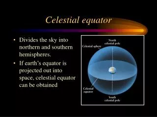
Sketching the HeavensNorth and South • Let’s create a vast celestial sphere. Above the north pole we will name Polaris as the north celestial sphere and 180 degrees away would be the South Celestial Sphere • Now let’s create a celestial equator • This measurement of degrees is called Declination • The declination information is contained in the Nautical Almanac
Sketching the Heavens • First we must pick a zero or beginning point • We call that the First Point of Aries
Point of Aries • At a right angle to the celestial equator at the point of Aries becomes zero • This is not a meridian line but rather an hour circle or as zero is called • HOUR CIRCLE OF ARIES • This is the celestial equivilent of the Prime Meridian and it becomes zero
Sidereal Hour Angle SHA • This is the measurement of the meridian lines that span the celestial heavens • Then only span westward 0-360˚ • We only measure in one direction so east and west are no longer necessary
Declination N SSidereal Hour Angle W • This is the coordinate system used for celestial navigation • The nautical almanac tabulates the positions of stars in SHA • Based on GHA or Greenwich Hour Angle or LHA Local Hour Angle • The Almanac is in GHA
Altitude Azimuth3rd Coordinate System • Your zenith • 180 degrees from you zenith is Nadir directly on the other side of earth • We can only see the things above our horizon line • Anything below our horizon line is denoted as negative altitudes • We need more than altitude to place a pinpoint a celestial body in our sky • We need an Asimuth
Azimuth Zn • We measure in reference to the horizon such as 0 degrees at true north • Runs clockwise up to 360 degrees
Altitude Azimuth • Uses the altitude in horizontal circles • Principal verticle circle (due north and south) • Azimuth in vertical circles • Each has an upper branch and a lower branch • Prime Vertical • Passes through 90 (which would be due east) 270 (which would be due west)