Download
1 / 62
660 likes | 789 Views
Understand the principles of conducting economic analyses for waterway improvements following USACE standards. Learn benefit measurement, planning settings, and NED evaluation. Explore primary references and benefit categories.

E N D
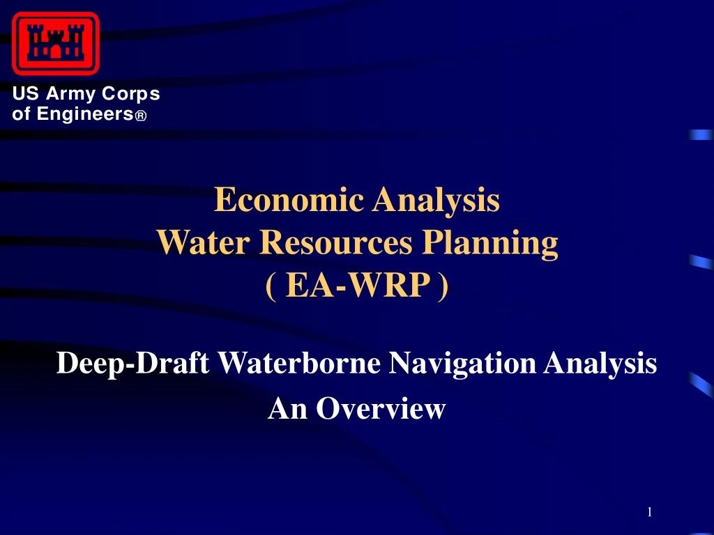
Economic Analysis Water Resources Planning( EA-WRP ) Deep-Draft Waterborne Navigation Analysis An Overview
Outline or Topic Agenda • I. Introduction; Purpose & Objectives • General References for Guidance & Procedures • II. Basis for Benefit Measurement Benefit Categories • III. Planning Settings • IV. National Economic Development (NED) Evaluation Process • V. Other\Notable Economic Considerations (continued)
Outline or Topic Agenda(continued) • VI. National Economic Development (NED Cost(s) • VII. Navigation Data & Related Sources • VIII. Abbreviated Exercise(s) • IX. Supplemental Information\Slides • X. End; Open Time for Questions/Discussion
Institute for Water Resources (IWR) • Navigation & Water Resources Applications Division (CEIWR-NA) • Ian A. Mathis (Economist); (703) 428-7257 7701 Telegraph Road Casey Building (Building #2594) Alexandria, Virginia 22315-3868
Purpose • To provide an overview of the requirements and procedures for conducting deep-draft navigation economic analyses in accordance with standards and guidance as applied by the U.S. Army Corps of Engineers (USACE).
Objective(s) • Identify the General Concepts and Procedural Steps for Economic Analysis Applied to the Study of Deep-Draft Waterway Improvements Under National Economic Development (NED) Criteria. • Identify primary sources of guidance and data , and exposure to some of the general terminology applied for studies.
Primary References for Planning and Analytical Guidance • Water Resource(s) Council’s (WRC)Economic and Environmental Principals and Guidelines for Water and Related Land Resources Implementation Studies [alternatively identified as the Principals and Guidelines or “P&G”) • Engineering Regulation (ER) 1105-2-100 [ alternatively identified as the Planning Guidance Notebook or “PGN” ] (continued)
Primary References for Planning and Analytical Guidance (continued) • Planning Manual [IWR Report No. 96-R-21; November 1996] • National Economic Development (NED) Procedures Manual - Deep-Draft Navigation [ IWR Report No. 91-R-13; November 1991 ] • Engineering Manual (EM) 1110-2-1613, Hydraulic Design Guidance for Deep-Draft Navigation Projects [April 1983 or as currently revised]
Conceptual Basis for Benefits • The Reduction In The Value of (Economic) Resources Required to Transport Cargo or Commodities and • The Increase In The Value of Output for Associated Goods and Services
Principal Direct Economic Benefits • Elimination or Reductions in Transportation Cost(s) • Benefits for Shift-of-Origin or Shift-of- Destination • Induced Movements
Elimination or Reductions In Transportation Costs(s) • Employment of Larger Vessels • More Efficient Use of Vessels • Lower Tug Assistance or Handlings Cost(s) • Reductions In Transit Time (Waterborne or Landside, etc.) • Use of Alternative Mode (Land vs. Water, etc.)
Shift-of-Origin/Destination & Induced Movements Benefits • Shift-of-Origin/Destination - Realignment to/from Other Ports or Transport Facilities (typically to reduce costs) • Induced - Change in Mode or Scale of Cargo Throughput Activity and Related Cost(s) Via New or Unique Movements That Would Not Have Occurred or Existed Without Waterway Improvements
Planning Settings • Historical Conditions • Existing Conditions • Future Conditions • “With-Project” • “Without-Project”
“Without-Project” Condition(s) • In the General Context of Planning: The Most Likely Condition(s) Expected to Prevail Over the Planning Horizon in the Absence of a Specified Course of Action or Plan. • Specific to USACE Navigation Studies: The Most Likely Conditions Expected to Prevail Without the Implementation of Proposed Waterway Improvements.
“With-Project” Condition(s) • In the General Context of Planning: The Most Likely Condition(s) Expected to Prevail Over the Planning Horizon if a Given Course of Action or Plan is Implemented. • Specific to USACE Navigation Studies: The Most Likely Conditions Expected to Prevail and Uniquely Attributable to Implementation Proposed Improvements.
Basic Economic Criteria for Plan Formulation\Selection\Optimization • Plan, Alternative or Increment Where Net Economic Benefits (Above Project Costs) are Maximized…… …Subject to Reasonable Assessment of Marginal or Incremental Economic Costs vs. Benefit(s) or Economic Return(s).
Basic Steps of the Evaluation Process • As Presented by the Principals and Guidelines (P&G) • As Presented by the NED Procedures Deep- Draft Manual (IWR Report 91-R-13; November 1991) • Process is Not Characteristically Comprised of Rigid or “Discreet” Requirements in Terms of a Detailed Model, Structure, or Order of Process for Analysis………
WRC’s P&G 9-Step NED Evaluation Process Schematic 1 Determine the Economic Study Area 2 Identify Commodity Types, Volumes, & Flows 4 Determine Vessel Fleet Composition and Costs 3 Project Waterborne Commerce 5 Determine Current Commodity Movement Cost(s) 6 Determine Alternative Movement Cost(s) 7 Determine Future Commodity Movement Cost(s) 8 Determine Harbor Use With and Without Project Implementation 9 Compute NED Benefits
NED Procedures Deep-Draft Navigation Manual 9 Step Evaluation Process 4 Determine Vessel Fleet Composition and Costs 2 Identify Commodity Types, Volumes, & Flows 5 Determine Current Commodity Movement Cost(s) 1 Determine the Economic Study Area 6 Determine Alternative Movement Cost(s) 3 Project Waterborne Commerce 7 Determine Future Commodity Movement Cost(s) 8 Determine Harbor Use With and Without Project Implementation NED Multi-Port Analysis 9 Compute NED Benefits
Determine Economic Study Area • Origin to Destination • Will Vary by Commodity • Competing ports and modes are factors
Identify Commodity Types, Volumes & Flows • Which commodities are likely to be impacted by the proposed improvement. • What are the expected tonnages • What are the expected routes
Project Waterborne Commerce • Projections supplemented with interviews and historical data. • By commodity • 20 years is usually sufficient • Sensitivity Analysis
Vessel Fleet Service Composition Cost(s) • Vessel Characteristics • Route, Commodity, Distance • Draft, DWT, Immersion Factors • Current and Future Fleets • Vessel Operating Costs
Determine Current Costs of Commodity or Cargo Transport (With Regard to Origin/Destination as Appropriate) • Ocean Transit Costs • Handling/Transfer Costs • Hinterland/Tributary (Landside or Inland Waterway) Transit Cost(s)
Determine Alternative Movements Cost(s) (Next Best Alternative(s); Applicable?) • Lightering, Topping-Off, or Offshore Facilities • Transhipment Facilities • Pipelines • Traffic/Port Facility Management • Other Transport Modes • Competitive Harbors • Other?
Determine Future Commodity Movement Cost(s) Relative to Foreseeable & Probable Changes In: • Fleet Service and/or Composition • Port Logistics (Delays, Throughput Process, etc.) • Port Throughput Capacity (Undertaken Relative to Time & Resources)
Determine Harbor or Waterway System Use Under “With” &\vs. “Without-Project” Conditions • Compare costs for alternatives to determine use • Integrate Multi-Port Analysis (as Appropriate) • Identify and Quantify Uncertainties
Calculate or Quantify National Economic Development (NED) Benefits (Cost Reduction Benefits - Examples) • Same Cargo Flow, Origin/Destination, Harbor • Same Cargo Flow, Origin/Destination, New or Alternative Harbor • Same Cargo Flow, Origin/Destination, Alternative Mode. • Induced Movement
Notable Economic Evaluation Considerations • Fleet changes • Service changes • Vessel Load Parameter(s) and Logistics • Commodity changes • Sensitivity • R&U (continued)
General Guideline for Level of Effort for Process or Analysis • Undertaken Until It Is or Can be Determined Additional Significant Effort or Analysis Would Not Yield or Result In a Significant Variance in Finding Concerning Disposition for Both Justification and Plan Formulation….. …………Subject to Time and Budgetary Constraints for Studies…….
Historical Findings of the Army Audit Agency (AAA) • Economic benefits often or typically overstated (relative to intent of applied guidance) • General lack or absence of multi-port analysis • Commodity\cargo projections not current or updated as might otherwise be appropriate • Frequent inconsistencies in fleet service projections • Vessel\Carrier size often overstated or overestimated • Inconsistency(ies) in comparison of with vs. without-project conditions.
Short Break • 10 Minutes
Abbreviated Exercise(s) • Plan Formulation\Selection\Optimization • Sample Calculation of Vessel Loading(s) & Immersion, & Derivation of Associated cargo Unit Costs • Bulk Carrier • Containerized Cargo Carrier
Navigation Data & Related Sources - General • Required Sources are Multiple or Numerous……Currently There Does Not Exist One Singular Source Applicable to the Needs of USACE Deep-Draft Navigation Studies • Not Always Readily or Consistently Available in Desired Level of Detail or in Time Series for All Studies • Sources Often Require Notable Lead and Labor Time to Acquire & Compile, Reconcile, and Refine • Applicable Sources Include Governmental & Private-Sector Entities • Some Critical Sources are Commercially-Based and Require Purchase for Acquisition • Nature of Data Requires Update or Currency for Reasonable Analysis(reference supplemental slides for a listing of typical sources)
Supplemental Slides\Information for Reference\Individual Review • General Schematics for Considerations of Risk & Uncertainty (R&U) Analysis • General Schematics for Waterway Terminology\Nomenclature • Information Concerning Research Efforts for Improvements to Waterborne Navigation Analysis & Planning
General Schematics for Waterborne Navigation Risk & Uncertainty • “Flow” Diagram • “Hierarchal-Order” Diagram
Deep-Draft Navigation Risk(s) & Uncertainty (R&U) (“Flow” Diagram) Environmental Risk(s) National Economic Development (NED) Cost(s) Uncertainty National Economic Development (NED) Benefit(s) Uncertainty 1 2 3 Waterway System (or Feature) Dimension/Specification Uncertainty >Depth, Width, and Alignment >Length or Duration >Lead/Lag Time Vessel Safety > Vessel Clearance(s) - Underkeel/Passing Clearance(s) > Maneuverability Vessel Traffic Uncertainty >Cargo/Commodities >Service Schedule(s) >Vessel Specifications 4 5 6 7 8 9 Waterway System (or Feature) Maintenance Uncertainty > Dredging\Excavation - Volume, Scheduling, & Cost(s) > Material Disposal Shoaling/Sedimentation Uncertainty > Sediment Flow/Transport - Degree, Nature, and Location of Material Deposition > Other Fleet Forecast Uncertainty Commodity Forecast Uncertainty Vessel Operations Uncertainty Total Navigation Study/Project Uncertainty
Deep-Draft Navigation Risk(s) & Uncertainty (R&U) (“Hierarchal-Order” Diagram) Navigation Project Uncertainty NED Cost(s) Uncertainty NED Benefit(s) Uncertainty Construction Cost(s) Maintenance Cost(s) Voyage Cost Estimates Disposal Cost(s) Dredging Cost(s) Traffic Projections Disposal Cost(s) Dredging Cost(s) Construction Quantities Operating Cost Estimates Vessel Operating Practice(s) Advance Maintenance Quantities Maintenance Quantities Dredging Allowance Fleet Projections Design Quantities Existing Dimensions Existing Dimensions Dredging Allowance Commodity Projections Advance Maintenance Quantities Design Dimensions Design Vessel Design Conditions
General Schematics for Waterway Terminology or Nomenclature • Conceptual Coastal Waterway\Entrance Layout • (Overhead\Horizontal Plane Perspective) • Waterway\Channel Cross Section(s) • (Vertical Plane Perspective; Typical Interior\Protected vs. Entrance\Ocean Approach Channel Segments) • Vessel Underkeel Clearances and Waterway Specifications • (Cross Section;Vertical Plane Perspective)
Conceptual Waterway\Entrance Layout Turning\Maneuvering Basin Transit Channel Segment Turn\Transition Transit Channel Wideners Quay or Berthing Area(s) Ocean Approach\Entrance Ocean Approach Reference Depth: 48.0 Feet MLLW Ocean Approach Contour Interior\Protected Reach Reference Depth: 45.0 Feet MLLW Protective Jetty(ies) Interior\Protected Reach
General Channel Cross Section Schematic Protected Water Reaches\Interior Channels * (Basic Increments for Depth Excavation) +5.0 ft. Mean Tide Variation Above Reference Datum ( MLW to MHW or MLLW to MHHW ) +5.0 ft. 0.0 ft. Waterway Reference Depth ( as Authorized & Maintained; Includes Allowances for Squat and Freshwater\Load Zone Sinkage; Required ) • 45.0 ft. Reference (Bottom) Width • 45.0 ft. • 45.0 ft. – (1+) Margin for Advance(d) Maintenance ( Required ) • 45.0 ft. – (1+) • 45.0 ft. – (1+?) Margin for Dredging Tolerance ( Allowable ) • 45.0 ft. – (1+?) * Vertical Plane Perspective of Waterway Cross Section
General Channel Cross Section Schematic Ocean Approaches\Entrance Channels * (Basic Increments for Depth Excavation) +5.0 ft. Mean Tide Variation Above Reference Datum ( MLW to MHW or MLLW to MHHW ) +5.0 ft. 0.0 ft. • 45.0 ft. Waterway Reference Depth ( as Authorized & Maintained; Required ) Marginal Width for Coastal\Open Water Climatic Conditions Reference (Bottom) Width • 45.0 ft. Margin for Coastal\Open Water Climatic Conditions ( Required ) • 45.0 ft. – (2+) • 45.0 ft. – (2+) Margin for Advance(d) Maintenance ( Required ) • 45.0 ft. – (1+) • 45.0 ft. – (1+) Margin for Dredging Tolerance ( Allowable ) • 45.0 ft. – (1+?) • 45.0 ft. – (1+?) * Vertical Plane Perspective of Waterway Cross Section
Vessel Underkeel Clearance(s) and General Waterway Depth Specifications Mean High Reference Level Above Reference Datum (I.e., MHW or MHHW) Mean Tide Variation (MTV) Reference Datum (i.e., MLW or MLLW) Vessel Hull Vessel Loaded\Laden Draft (i.e., Transit Draft; Static Condition) Effect of Freshwater (Sinkage) Waterway Design Depth(s) (or Increments) Vessel Vertical Motion Due to Climatic Conditions (Significant Wind & Waves, etc.) Gross Underkeel Clearance (Static condition) Vessel Squat (Dynamic\Underway) Net Safety Clearance Waterway Reference Depth ( as Authorized & Maintained; Dredging Depth Margin Required ) Advance(d) Maintenance ( Dredge Required ) Dredging Tolerance ( Dredge Allowable ) Mean Bed Level
Supplemental Slides\Information for Reference\Individual Review • Information Concerning Research Efforts for Improvements to Waterborne Navigation Analysis & Planning
Activities for Integration of Engineering and Economic Analysis [Undertaken with the Support of the U.S. Naval Academy USNA)] • Design Procedure Literature Review • Comparison of Study Procedures (& field surveys) • Channel Design & Maintenance Assessment • Safety Performance Review • Shipping Trends Analysis • Summary Report of Findings & Recommendations
Ongoing Investigations\Evolving Methods or Guidance • Efforts to Enhance the Integration of Engineering & Economic Analysis for Planning of Waterway Design. • Efforts to Develop Practical/Applied Methods Analysis of Risk & Uncertainty (R&U) in Planning of Deep-Draft Navigation Projects.