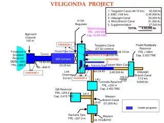
Download
1 / 40
400 likes | 520 Views
El canal 8, d’Ozó. Rep radiació IR. Característiques similars a la de la resta de canals IR. Nova propietat: detecta el contingut d’ozó a capes altes troposfèriques, aquest producte està en desenvolupament. Canal 11, del CO 2.

E N D
El canal 8, d’Ozó • Rep radiació IR. • Característiques similars a la de la resta de canals IR. • Nova propietat: detecta el contingut d’ozó a capes altes troposfèriques, aquest producte està en desenvolupament.
Canal 11, del CO2 • Ens trobam en un costat de una finestra d’absorció de CO2 centrada a 15 mm. • Qualitativament no aporta res nou. • Quantitativament, sense niguls permet calcular perfils de temperatura de la baixa troposfera i detectar inestabilitats.
Diferències de canals: • Per a realçar fenòmens concrets, normalment es representen en escala de grisos (com les imatges d’un sol canal) • Les més usades són: • 4-9 : boires i niguls baixos. • 3-1 : Niguls de gel
nit - fosc dia - brillant Només dia - foscs 04 – 09 boira 03 – 01 Niguls de gel
Composicions de color: • Es tracta d’assignar un canal a cada un dels colors fonamentals (RGB) d’una imatge en color. • També s’anomenen combinacions RGB
Combinacions recomanades per Eumetsat • Composició RGB Aplicacions • RGB 03,02,01: Vegetació, Neu, Fum, Pols, Boira dia • RGB 02,04r,09: Niguls, Convecció, Neu, Boira, Focs dia • RGB 02,03,04r: Neu, Boira. Dia • RGB 05-06,04-09,03-01: Convecció severa dia • RGB 10-09,09-04,09: Niguls, Boira, Esteles de vaixells nit • RGB 10-09,09-07,09: Pols, niguls prims, Contrails dia I nit • RGB 05-06,08-09,05: Ciclons severs, corrents en doll, Anàlisi PV dia i nit
Color natural RGB 321 • R = Canal 03 (NIR1.6) • G = Canal 02 (VIS0.8) • B = canal 01 (VIS0.6) Aplicacions: Vegetació, Pols, Fum, boira, neu Temps: dia
Ch.03 NIR1.6 Ch.02 VIS0.8 Ch.01 VIS0.6
RGB 03, 02, 01 Exemple: Neu, color cyan MSG-1, 18 February 2003, 13:00 UTC
RGB 03, 02, 01 Exemple: Vegetacio apareix en verd MSG-1, 23 June 2003, 15:00 UTC
RGB 03, 02, 01 Exemple: Desert MSG-1, 3 February 2004, 11:30 UTC
RGB 03, 02, 01 Exemple: Niguls baixos d’aigua (St, Sc) MSG-1, 03 February 2004, 11:30 UTC
RGB 03, 02, 01:Iinterpretació dels colors Niguls alts de gel Niguls baixos d’aigua Ocean Veg. Land Desert Snow
2. RGB 02, 04r, 09 (“microfísica diürna") R = Canal 02 (VIS0.8) G = Canal 04r (IR3.9, component solar) B = Canall 09 (IR10.8) Aplicacions: Anàlisi de niguls, Convecció, Boira, Neu, Focs Temps: Dia-nit
Ch.02 VIS0.8 Ch.04r IR3.9r Ch.09 IR10.8 MSG-1, 8 September 2003, 12:00 UTC RGB Composite 02, 04r, 09 "winter" enhancement(see previous slide)
RGB 02, 04r, 09 Exemple:Convecció severa MSG-1, 20 May 2003, 13:30 UTC ("winter" enhancement)
RGB 02, 04r, 09 Exemple: Focs MSG-1, 7 September 2003, 11:45 UTC ("winter" enhancement)
Thin Cirrus cloud (large ice particles) Thin Cirrus cloud (small ice particles) Ocean Veg. Land Fires / Desert Snow RGB 02, 04r, 09: Interpretació dels colors per a niguls alts Deep precipitating cloud (precip. not necessarily reaching the ground) - bright, thick - large ice particles - cold cloud Deep precipitating cloud (Cb cloud with strong updrafts and severe weather)* - bright, thick - small ice particles - cold cloud *or thick, high-level lee cloudiness with small ice particles
Ocean Veg. Land Fires / Desert Snow RGB 02, 04r, 09: Interpretació dels color per a niguls mitjos Supercooled, thick water cloud - bright, thick - large droplets Supercooled, thick water cloud - bright, thick - small droplets Supercooled thin water cloud with large droplets Supercooled, thin water cloud with small droplets * * or, in rare occasions, thin Ci cloud with small ice particles
Ocean Veg. Land Fires / Desert Snow RGB 02, 04r, 09: Interpretació dels colors per a niguls baixos. Thick water cloud (warm rain cloud) - bright, thick - large droplets Thick water cloud (no precipitation) - bright, thick - small droplets Thin water cloud withlarge droplets Thin water cloud with small droplets
3. RGB 02, 03, 04r (“Solar diürn") R = Canal 02 (VIS0.8) G = Canal 03 (NIR1.6) B = Canal 04r (IR3.9r, component solar) Aplicacions: Boira/niguls baixos, neu. Area: Mitges I altes latituds Time: De dia a l’Hivern
RGB 02, 03, 04r Exemple: Neu MSG-1, 26 January 2004, 10:00 UTC
RGB 02, 03, 04r: Interpretació dels colors per a niguls gruixats tant de gel com d’aigua. Deep precipitating cloud (precip. not necessarily reaching the ground) - bright, thick - large ice particles Deep precipitating cloud* - bright, thick - small ice particles *or thick, high-level lee cloudiness with small ice particles Thick water cloud withlarge droplets Thick water cloud with small droplets Ocean Veg. Land Desert Snow
4. RGB 05-06, 04-09, 03-01 (“Tempestes convectives") R = Diferència WV6.2 - WV7.3 G = Diferència IR3.9 - IR10.8 B = Diferència NIR1.6 - VIS0.6 Aplicacions: Tempestes severes convectives. Area: tot l’hemisferi. Temps: diürna.
RGB 05-06, 04-09, 03-01 Exemple:Convecció severa RGB 02,04r,09 RGB 05-06,04-09,03-01 (per comparació) millor identificació de tempestes joves. MSG-1, 20 May 2003, 13:30 UTC
RGB 05-06, 04-09, 03-01 Example:Severe Convection RGB 02,04r,09 RGB 05-06,04-09,03-01 (per comparació) millor identificació de tempestes joves MSG-1, 13 June 2003, 12:00 UTC
RGB 05-06, 04-09, 03-01 Global View MSG-1 5 September 2004 15:00 UTC
RGB 05-06, 04-09, 03-01:Interpretació dels colors Deep precipitating cloud (precip. not necessarily reaching the ground) - high-level cloud - large ice particles Deep precipitating cloud (Cb cloud with strong updrafts and severe weather)* - high-level cloud - small ice particles *or thick, high-level lee cloudiness with small ice particles Thin Cirrus cloud (large ice particles) Thin Cirrus cloud (small ice particles) Ocean Land
5. RGB 10-09, 09-04, 09 (“Microfísica nocturna") R = Diferència IR12.0 - IR10.8 G = Diferència IR10.8 - IR3.9 B = Canal IR10.8 Aplicacions: Anàlisi de niguls, boira, esteles de barcos. Area: tot l’hemisferi Temps: nocturna
RGB 10-09, 09-04, 09 Exemple: Cb MSG-1, 19 April 2005, 03:15 UTC
RGB 10-09, 09-04, 09 Exemple: Cirrus MSG-1, 18 March 2005, 00:00 UTC
RGB 10-09, 09-04, 09 Visió global MSG-1 3 February 2004 03:00 UTC
RGB 10-09, 09-04, 09: Interpretació dels colors per niguls alts. Cold, thick, high-level cloud Very cold (< -50°C), thick,high-level cloud Thin Cirrus cloud Ocean Land
Low-level cloud (cold atmosphere, Europe) Low-level cloud (warm atmosphere, Africa) RGB 10-09, 09-04, 09: Interpretació dels colors per niguls mitjos. Thick, mid-level cloud Thin, mid-level cloud Ocean Land
7. RGB 05-06, 08-09, 05i (“Massa d’aire") R = Diferència WV6.2 - WV7.3 G = Diferència IR9.7 - IR10.8 B = Canal WV6.2i Aplicacions: Ciclogènesi ràpida, Anàlisi de la corrent en doll, anàlisi PV. Area: Tot l’hemisferi Temps: Dia I nit.
RGB 05-06, 08-09, 05i Exemple: Corrent en doll MSG-1, 7 January 2005, 22:00 UTC
RGB 05-06, 08-09, 05i Exemple: Massa freda MSG-1, 7 January 2005, 22:00 UTC
Jet (high PV) Cold Airmass Warm Airmass Warm Airmass RGB 05-06, 08-09, 05i:Interpretació dels colors Thick, high-level clouds Thick, mid-level clouds Thick, low-level clouds (warm airmass) Thick, low-level clouds (cold airmass) High UTH Low UTH