Download
1 / 1
10 likes | 94 Views
Learn how a diverse team is using weather data in ecological research, hydrological modeling, educational programs, and urban climate studies. Discover the impact of different weather instruments on data collection accuracy and sustainability.

E N D
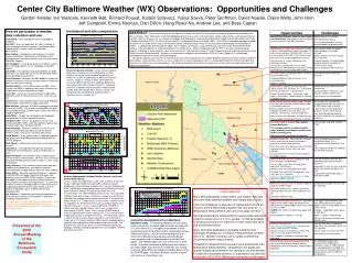
BWI Instrument and site comparisons How we participate in weather data collection and use: Larry Band – Uses precipitation data in hydrological modeling. Ken Belt – Uses rain gage data for urban hydrology & stream ecology research, maintains a backyard station (tipping bucket, manual, snow, miscellaneous observations). . Bess Caplan – Collaborates with teachers at Franklin Square and William Pace Elementary Schools and in development of curriculum on weather for the after-school KidsGrow Program. Jeff Campbell – Is researching the use of citizen scientist data, including weather, for the hydrology visualization project. Dan Dillon – Has collected and archived BES rain-gage data and is the contact person for the Weatherbug station at Oregon Ridge Nature Center. Peter Groffman – Manages the BES budget that goes for weather instruments and uses weather data in research on both soil and stream ecology. Gordon Heisler – Uses weather data from BES, Forest Service, and NWS in modeling urban forest influences on temperatures across the Baltimore region. John Hom – Assesses CO2 concentration in downtown Baltimore and Cub Hill and measures CO2 fluxes at Cub Hill. Andrew Lee – Uses weather data in watershed modeling, which includes estimation of evapotranspiration. Mike McGuire –Manages CUAHSI Hydrologic Information System at CUERE. This includes making BES rain gage data available through CUAHSI web services and internet mapping applications. Andy Miller – Studies rain distribution and hydrologic consequences of intense convective storms. Hang Ryeol Na – Carries out quality assurance and archiving on BES, NWS, and Forest Service weather data, including submission of data to ClimDB. Emma Noonan – Maintains weather instruments and collects weather data from BES and Forest Service weather stations and carries out initial data checks. David Nowak – Uses weather data in modeling air quality and energy use for building space conditioning with the UFORE program. Rich Pouyat – Models soil environments with weather data as input. Julia Savva – Developing a technique for statistical modeling of soil temperatures using air temperature as input. Martin Schmidt – Uses weather data in teaching earth science to high school students. Archives and summarizes data from the BES primary weather station in a form useful in education. Kathy Szlavecz – Uses weather data in measuring and modeling soil temperatures and recently acquired instrumentation to report weather data from Johns Hopkins. Claire Welty – Recently acquired funding to (1) upgrade the BES/USGS rain-gage network to dual gages and telemetry using the USGS GOES satellite: (2) purchase and deploy a new eddy covariance station to carry out measurements of urban water vapor fluxes, (3) assimilate weather and other hydrological data in near-real time to a coupled groundwater-surface water model, and (4) to archive and provide access to BES chemical and hydrologic data. Ian Yesilonis – Coordinates day to day management of Forest Service weather instrumentation in Baltimore, including site permissions. This represents just some BES use of weather data. If you are not on this list and should be, please send your weather and climate related activities to Gordon Heisler at gheisler@fs.fed.us. ABSTRACT--Observations of weather are important in studies of human thermal comfort and health, biogeochemical processes in soils and water, urban stormwater runoff, microbiological growth and survival, ozone formation, carbon sequestration, and tree planting and mortality. Some of these issues are studied in the Watershed 263 project, a partnership of Baltimore Department of Public Works with Parks & People Foundation (PPF), the Forest Service (USFS), and Baltimore Ecosystem Study (BES). The USFS is developing methods to model the pattern of air temperatures across the Baltimore region, and observations within the city are critical to developing and validating the models. In collaboration with IES and the USFS, Johns Hopkins University is using weather data, some from their downtown Baltimore campus, in the development of statistical models of soil temperatures. BES is collaborating with the PPF in the after-school education program, KidsGrow, in which weather is part of the curriculum. Two KidsGrow schools, Franklin Square Elementary School and Harlem Park School are within Watershed 263. Weather instrumentation installed and maintained by USFS at Franklin Square E.S. will add both knowledge and excitement to the KidsGrow program. This poster indicates some sources of weather data and shows comparisons of variables between locations and some trends in long-term observations. Some of these sources use new, inexpensive instrument packages, and it is a challenge to determine whether durability and accuracy are sufficient for research purposes. We compare the performance of some inexpensive systems with more robust but also more expensive instruments. Center City Baltimore Weather (WX) Observations: Opportunities and Challenges Recent temperature trends. Annual and July (above) daily mean temperatures at the BES primary station show an increasing trend that generally parallels the NWS sites at BWI and downtown (DMH at the Science Center), except in summer of 2007, when DMH was unusually higher than the others (perhaps because of construction around the Science Center?). Large Avg. trend of 3 ºC/decade may be example of what climate change looks like, though these 9 years are too short to represent the real long-term warming, which is significant but at a smaller rate. 1 2 Gordon Heisler, Ian Yesilonis, Kenneth Belt, Richard Pouyat, Katalin Szlavecz, Yuliya Savva, Peter Groffman, David Nowak, Claire Welty, John Hom Jeff Campbell, Emma Noonan, Dan Dillon, Hang Ryeol Na, Andrew Lee, and Bess Caplan 3 Weather Underground, National Weather Service, and Forest Service/ARS stations. Graph 1 showsair temperatures at four sites at and near the Inner Harbor: Downtown NWS (Call sign DMH) at Science Center, Collaborative Forest Service and Agric. Res. Service Station beside DMH, and Weather Underground stations at the Baltimore Sun and South Baltimore. Notice he effects of site differences and instrumentation. The DMH temperature sensor has a fan-aspirated radiation shield and it shows a relative fast response and minimum radiation error (though measurements are only for 2 min each hour and to nearest 1 ºF. Temperature sensors on other stations are not fan aspirated. Air temperature errors are caused by radiation and slow time constants. Graph 2 shows DMH minus FS/ARS (in yellow) and solar radiation (aqua), and Graph 3 shows wind measured by FS/ARS. When sun is strong, FS/ARS tends to measure high, but when wind is strong as on 7/13, it ventilates the temperature system and reduces the error. The South Balt. station is above the roof of a town house row and on sunny afternoons shows about 2 ºC higher temp than DMH, which is probably partly a radiation error and partly an effect of being near the hot roof. The Baltimore Sun station may be in a sheltered location among tall buildings. (Weather Underground data from Jeff Campbell. FS/ARS data from John Hom.) Conclusions Many BES participants collect and/or use weather data and there are many potential weather and climate data sources. There are limitations on accuracy of measurements from all sources, but the BES primary system has very good air temperature measurements with just a few gaps over 8 yr. Accurate temperature measurements require power-aspirated shields to avoid errors of 2 ºC or greater. It may be possible to develop corrections for these errors from concurrent wind and cloud observations. Many ecological applications, probably including most hydrologic modeling, do not require measurements to better than 2 ºC. Models of energy use for space conditioning should have better measurements. Precipitation measurements are even more problematic than temperature measurements. Inexpensive rain gages can usually reliably report whether it is raining or not and whether it is light rain, moderate showers, or a downpour, but don’t be surprised by 20 to 30 % differences from better quality gages. Cumulative precipitation at four downtown Baltimore sites.The National Weather Service station (yellow above) has a heated, tipping-bucket rain gage with a 12-inch orifice at a 1-m height surrounded by a wind shield that is part of the ASOS system (Automated Surface Observing System). NOAA has worked diligently over more than a decade to develop accurate precipitation measurements and still acknowledges errors with their gages. The FS/ARS gage has a 6.5” orifice and no wind shield. The South Baltimore and Baltimore Sun stations are Davis gages, also about 6.5” in diameter, but costing even less (about $100 not including recording device) than the FS/ARS gage. The South Baltimore station is above roof level over a townhouse row. Presented at the 2008 Annual Meeting of the Baltimore Ecosystem Study