Download
1 / 48
490 likes | 803 Views
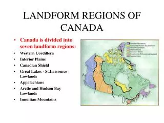
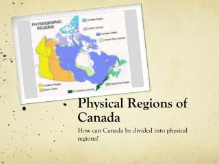
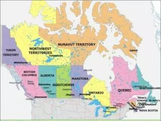
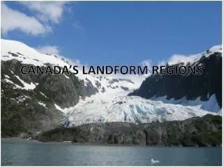
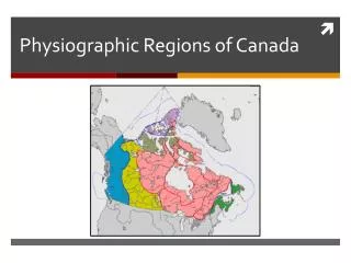
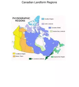
Canada’s Landform Regions. Landform Region Map. Canada has three basic types of landforms. 1. Shield 2. Highlands 3. Lowlands They form a pattern. The Creation of Canada’s Landforms!.

E N D
Canada has three basic types of landforms.1. Shield 2. Highlands 3. Lowlands They form a pattern.
The Creation of Canada’s Landforms! The next few slides contain a series of hand drawn images illustrating the creation of Canada’s Landform regions.
1. Precambrian Canada Erosion Transportation Transportation Deposition Deposition Plate Collision 2. Paleozoic Canada Folded Mountains
3. Mesozoic Canada Plate Collision 4. Cenozoic Canada Western Cordillera Appalachians Canadian Shield Great Lakes - St. Lawrence Lowlands Interior Plains Glaciers!!! – ended about 20 000 years ago Landforms not seen (in the back) - Hudson Bay Lowlands, - Arctic Lowlands, - Innuitian Mountains
Western Cordillera • Mountains of the Yukon • Notice the jagged peaks • If you looks carefully, you will also see glaciers
Western Cordillera • One of the large glaciers found in the Yukon
Western Cordillera • A glacier-fed lake in Jasper National Park in Alberta
Western Cordillera • Jasper National Park • The valley is U-shaped because it was carved by a glacier, not the river you see here
Western Cordillera • The Coast Mountains provide a dramatic backdrop in this picture of North Vancouver, BC
Interior Plains • Farmland near the Red River in Southern Manitoba
Interior Plains • The meandering Red River in Southern Manitoba
Interior Plains • The Cypress Hills in Southern Saskatchewan
Interior Plains • The Qu’Appelle Valley in Southern Saskatchewan • A rare change from the flat landscape in this region
Interior Plains • Cows graze in a rocky field • These rocks, deposited by glaciers, are called moraine
Arctic Lowlands • Tundra in Nunavut • Notice the flat land and strewn rocks
Arctic Lowlands • The flat, exposed land of Prince Patrick Island in the Northwest Territories
Arctic Lowlands • Another image of Prince Patrick Island in the NWT • The flat land allows melting water to cover a vast area
Innuitian Mountains • The dramatic cliffs of Ellesmere Island, Nunavut
Innuitian Mountains • A glacier and its melt water on Ellesmere Island, Nunavut
Innuitian Mountains • Red rocks and barren landscape on Melville Island • Melville Island is divided between Nunavut and the Northwest Territories
Canadian Shield • Lake near Port Cartier, Quebec • Rounded hills in the background
Canadian Shield • Exposed rock along the lakeshore • Notice the scratches in the rock • They were caused by glaciers
Canadian Shield • Boulder field in the Northwest Territories • More evidence of glaciation
Canadian Shield • A boulder in the Northwest Territories • It was deposited here by a retreating glacier
Canadian Shield • Exposed rock near Abitibi, Quebec • The scratches are the result of a glacier
Great Lakes – St. Lawrence Lowlands • Typical farm in Ontario
Great Lakes – St. Lawrence Lowlands • The city of Toronto from the air • Notice the lack of hills • Also notice the smog
Great Lakes – St. Lawrence Lowlands • Farmland near Toronto
Great Lakes – St. Lawrence Lowlands • Southern Ontario from the air • Notice the flat horizon
Hudson Bay Lowlands • A wetland known as a muskeg in Northern Manitoba
Hudson Bay Lowlands • The watery terrain outside Churchill, Manitoba
Hudson Bay Lowlands • The water-filled landscape near Fort Severn, Ontario
Hudson Bay Lowlands • A forested bog outside Gilliam, Manitoba
Appalachian Mountains • Rocky shoreline at West Dover, NS • The boulders were deposited by glaciers
Appalachian Mountains • Valley in Cape Breton • Notice the rounded mountains
Appalachian Mountains • Aspy Bay in Cape Breton
Appalachian Mountains • Cape Breton Highlands • The mountains have been flattened by erosion