Download
1 / 21
210 likes | 433 Views
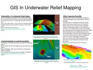
GIS Mapping of Providers. eWiSACWIS November 4 th , 2010 Jesus Mireles, et.al . Waukesha County. The Issues?. Where is the closest provider to an address? Does that provider have available space? In case of a natural emergency, are the children safe?

E N D
GIS Mapping of Providers eWiSACWIS November 4th, 2010 Jesus Mireles, et.al. Waukesha County
The Issues? • Where is the closest provider to an address? • Does that provider have available space? • In case of a natural emergency, are the children safe? • Are there children in my county in placements from adjoining Counties? • Where are they and are they safe? • What else should I consider when placing a child?
Why Involve the State? • State requirement to locate children during emergency • Cross County Placements • Required data held by State • Willing Partner in State GIO • Single system to be developed, deployed & maintained
How do We Make This Work? The FRAME • Map out Locations of All Foster Care Providers in State • Post on Secure Internet Site • Assistance Provided by State Geographic Information Officer The PICTURE • Establish link to eWiSACWIS Data • Provider Information • Child Information • Develop Workflow, Queries, and Reports • Workgroup to design and test
The EndQuestions?Don DittmarWaukesha County LIS Managerddittmar@waukeshacounty.gov