Download
1 / 53
530 likes | 675 Views
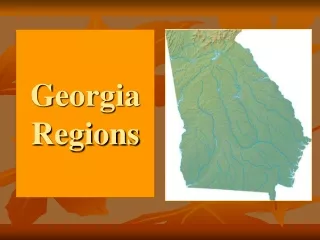
PHYSIOGRAPIC REGIONS OF GEORGIA. Standard: The student will describe Georgia with regard to physical features and location. STANDARD.

E N D
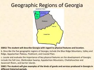
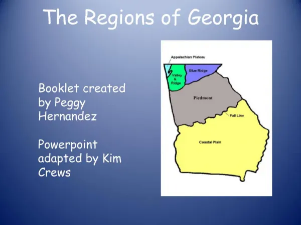
PHYSIOGRAPIC REGIONS OF GEORGIA Standard: The student will describe Georgia with regard to physical features and location
STANDARD What STANDARD are we studying?The student will describe Georgia with regard to physical features and location.What ELEMENT are we studying?Evaluate the impact of climate on Georgia’s development. ELEMENT
How is Georgia’s overall climate best described? • A. Dry and cold • B. Dry and hot • C. Humid and mild • D. Wet and hot
Which industry is MOST affected by Georgia’s mild climate? • A. Agriculture • B. Chemical • C. Mining • D. transportation
Georgia’s climate attracts business and industry because the state • A. Does not have hurricanes • B. Never receives much snow • C. Rarely experiences tornadoes • D. Has a consistently mild climate
In many cases, people have to adjust to a new physical and geographic environment in order to make a living. Which person would have to make the most drastic adjustment? • A. A Georgia cotton farmer moving to Canada • B. A computer programmer moving from Boston to Atlanta • C. A logger moving from the Georgia mountains to Maine • A Georgia miner moving from the plateau region to West Virginia
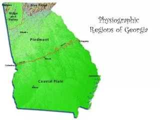
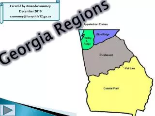
CRCT August 8: Physiographic Regions Blue Ridge Valley and Ridge Appalachian Plateau
Page 153 • The Blue Ridge region is located in the Northeastern part of the state. Part of the Appalachian Highlands that stretch from NY to Alabama, the highest and largest group of mountains in Georgia are in this area. These mountains are important to the state because they are the first barrier to moisture from the warm, moist air rising from the Gulf of Mexico.
Brasstown Bald, the highest peak in the state, is located in this region (the name comes from mountains that are treeless on the top – called “balds”). Brasstown Bald is almost 5,000 feet high. At the top of Brasstown Bald, you can see North Carolina, South Carolina and Tennessee.
Soil type: sandy loam and clay – • Well suited for hardwood forests, vegetable farming and apples. • Landmarks include Amicalola Falls (drops 729 feet), Tallulah Gorge (1,000 foot deep gorge), and the alpine community of Helen, GA
In which region are Amicalola Falls and Tallulah Gorge located? • Appalachian Plateau • Blue Ridge • Piedmont Plateau • Ridge and Valley
What is the highest peak in Georgia? • Amicalola Falls • Brasstown Bald • Cloudland Canyon • Tallulah Gorge
What states border the Blue Ridge region? • Tennessee, Alabama and Georgia • North Carolina and South Carolina • New York and Alabama via the Appalachian Trail • Texas, Alabama and Georgia
Ridge and Valley • The Ridge and Valley Region lies between the Blue Ridge Mountains and the Appalachian Mountains. • Most of the soil is a mixture of shale and sandstone on the ridges and limestone and clay in the valleys • Combination of forests and pastures, flat and fertile farmlands • Apple orchards near Ellijay – rocks resistant to erosion on the ridges – Taylor Ridge and Pigeon Mountain.
Valley and Ridge runs from Polk and Bartow counties northward to Chattanooga Tennessee • Known for industry – location of DALTON, THE CARPET CAPITAL OF THE WORLD • NORTHWEST GEORGIA location: • Plum Nelly is location of well known Appalachian folk art center.
In which region are Taylor Ridge and Pigeon Mountain formed? • Appalachian Plateau • Blue Ridge • Piedmont Plateau • Ridge and Valley
What famous industry is located in the Valley and Ridge area? • Chicken farming • Carpet • Sheep farms • Peanut farms
The Valley and Ridge are is located between what mountain areas? • Savannah and Macon • Okefenokee and Piedmont • Blue Ridge and Appalachian • Smokey and Ozark
Appalachian Plateau • The smallest physiographic region is made up of Limestone caves, canyons and rocks. Known as the APPALACHIAN PLATEAU, this is the region where Tennessee, Alabama and Georgia meet. It is also called “TAG Corner” or the Cumberland Plateau. • The region has broad flat topped Lookout Mountain on one side and Sand Mountain on the other.
The region has a mixture of limestone, shale and sandstone soil and is made up of hardwood forests and pastures • Coal also exists in this region, but there is no active mining at present • Elevation is 2,000 feet at the mountains – including the famous site of the Chickamauga Civil War battle • Springer Mountain, located between the Appalachian Plateau and the Ridge and Valley, marks the start of the Appalachian Trail.
Which physiographic region is the smallest, contains coal and Lookout Mountain? • Valley and Ridge • Coastal Plain • Blue Ridge • Appalachian Plateau
In what area of Georgia is the Appalachian Plateau located? • Southwest • Southeast • Northwest • Northeast
TAG corner refers to • The area in the Blue Ridge where Texas, Alabama and Georgia meet • The apple orchards of the Valley and Ridge region • Carpet Capital in Dalton, Georgia • The NW corner of Georgia where Tennessee, Alabama and Georgia meet.
What is a REGION? • An area on Earth’s surface defined by unifying characteristics • A region such as the Appalachian Plateau • The five physiographic areas of Georgia • All of the above
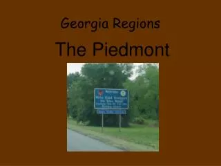
CRCT AUGUST 9th Physiographic Regions Piedmont, Coastal Plain, Fall Line, Okefenokee Swamp, Appalachian Mountains Pages 157 to 163
What city is located on the Fall Line? • A. Atlanta • B. Columbus • C. Summerville • D. Valdosta
Which city is located in the Piedmont? • A. Athens • B. Macon • C. Savannah • D. Trenton
In which region is Atlanta located? • A. Appalachian Plateau • B. Blue Ridge • C. Piedmont Plateau • D. Ridge and Valley
The geographical region that is home to about half the state’s population is • A. Piedmont • B. Coastal Plain • C. Blue Ridge • D. Appalachian Plateau
Which physiographic region covers the largest part of the state? • A. Piedmont • B. Coastal Plain • C. Appalachian • D. Valley and Ridge
Which region is known for the production of peanuts, corn and pecans? • A. Piedmont • B. Coastal Plain • C. Blue Ridge • D. Appalachian Plateau
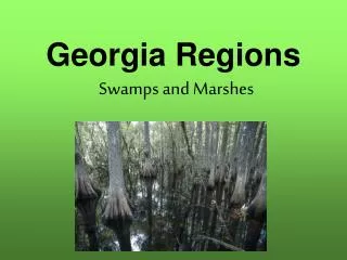
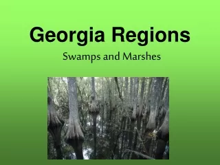
Which statement is not true of a wetland? • A. A wetland contains sloughs, swamps, bogs, ponds and freshwater marshes • B. A wetland is a low lying area where water is close to the surface • C. A wetland contains salt marshes and is found along the coast • D. A wetland is located in an area with heavy annual rainfall
Why have many cities and industries grown along Georgia’s Fall Line? • A. Railroads were already built there • B. Rapid flowing rivers were a source of energy • C. Ships can travel northward to the Northeast • D. The land was fertile and perfect for farming
What two regions are separated from the Fall Line? • A. Appalachian Plateau and Blue Ridge • Blue Ridge and Piedmont Plateau • Coastal Plain and Blue Ridge • Coastal Plain and Piedmont Plateau
The border between the Piedmont and Coastal Plain marking the point where rivers drop in elevation and create waterfalls is the • A. Fall Line • B. Tallulah Gorge • C. Savannah River • D. Okefenokee Swamp
Which is NOT a reason for settlements along the Fall Line? • A. Waterfalls at the Fall Line provided a power source • B. The area around the Fall Line with clear water and lush vegetation was attractive to settlers • C. The rivers and creeks provided softer soils for fertile farm lands • D. Settlers could not travel over the water falls
Which is a characteristic of Okefenokee Swamp? • It is located in the Piedmont area • It has the most precipitation in the state • It is famous for hydroelectric power • It is the largest freshwater marsh in Georgia
In which region is the Okefenokee Swamp located? • A. Blue Ridge • B. Coastal Plain • C. Piedmont Plain • D. Ridge and Valley
The mountain chain which reaches into northern Georgia is the • A. Appalachians • B. Ozarks • C. Rockies • D. Shenandoah
Through which physiographic regions do the Appalachian Mountains run? • A. Coastal Plain, Blue Ridge, Ridge and Valley • B. Blue Ridge, Appalachian Plateau, Coastal Plain • C. Ridge and Valley, Appalachian Plateau, Piedmont • D. Blue Ridge, Ridge and Valley, Appalachian Plateau
What states border Georgia? • Tennessee, Alabama, Missouri, North Carolina, South Carolina, Florida • Tennessee, Alabama, North Carolina, South Carolina, Florida • Tennessee, Alabama, Florida, Mississippi, Texas, South Carolina • North Carolina, South Carolina, Virginia
Physiographic Region Features Chattahoochee River Savannah River
What river is the primary source of water for Atlanta? • Altamaha • Chattahoochee • Flint • Savannah
What river has its headwaters in the mountains of North Georgia and form part of the boundary between Georgia and Alabama? • Altamaha • Chattahoochee • Flint • Savannah
The earliest settlement of Georgia by the first English colonists was along which Georgia river? • Altamaha • Chattahoochee • Ocmulgee • Savannah
What is the only river that flows into Georgia from another state? • Chattahoochee • Coosa • Ogeechee • Savannah
Using the map, which river forms the boundary between GA and SC? • Altamaha • Chattahoochee • Ogeechee • Savannah
Which river does NOT flow into the Atlantic Ocean? • Flint • Ocmulgee • St. Marys • Satilla