Download
1 / 19
190 likes | 298 Views
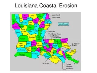
Status Report on the Re-evaluation of the Louisiana Coastal Zone Boundary. Dr. John Day December 9, 2009. PROJECT OVERVIEW. Technical and Analytical Support Services to the Office of Coastal Management for Re-evaluation of the Inland Boundary of the Louisiana Coastal Zone.

E N D
Status Report on the Re-evaluation of the Louisiana Coastal Zone Boundary Dr. John Day December 9, 2009
PROJECT OVERVIEW Technical and Analytical Support Services to the Office of Coastal Management for Re-evaluation of the Inland Boundary of the Louisiana Coastal Zone. Task 1 – Data Acquisition and Background Review Task 2 – Development of Methodology, Data Compilation and Analysis Stakeholder input Task 3 – Data Interpretation and Report Preparation
1975 Boundary Criteria • Regional Topographic Correlative Criteria • Geology = Pleistocene/Recent contact • Elevation = 5 and 25-ft contours • Soils = hydric/non-hydric boundary • Vegetation boundary = wetland/non-wetland • One hundred year flood and tidal inundation level • Point Location Correlative Criteria • Salinity = inland intrusion • Range or inland occurrence of brackish water clam, blue crab, fish (e.g., Striped mullet), birds (migrating waterfowl), mammals (e.g., Eastern mole), reptiles (e.g., Fence lizard)
2009 Boundary Criteria • Vegetation • Current elevation • Predicted subsidence/sea level rise • Inundation - storm surge • Watershed boundaries • Boundaries of existing coastal programs
Methodology An updated inland Coastal Zone Boundary should encompass: all areas subject to coastal processes; and all uses which have the potential to impact coastal waters The degree of management needed will vary by location and use Therefore, a tiered approach is proposed, with each tier defined by science based parameters and criteria to determine regulatory and non-regulatory policies and management scenarios
Proposed Tiered Approach TIER 1: Regulation by means of the Coastal Use Permitting Procedure TIER 2: Regulatory oversight by means of the Consistency Determination Procedure TIER 3: Non-regulatory management through incentive programs and planning initiatives
Tiering Criteria Based on Area and Use • Some of the factors that affect tiering criteria include • Potential effect on coastal waters • Nature of proposed land or water use • Federally excluded lands (e.g., fastlands, federally-owned lands) • Deepwater port, harbor, or terminal district • Current land use • Elevation (sea level rise, storm surge)
CZB Decision Matrix • State of LA? • Watershed that touches the coast? • Area of other LA coastal programs? • Area of inundation per MOMS/ADCIRC? • Affected by sea level rise (<8 ft)? • Below the Pleistocene Terrace? • Intermediate, brackish, saline marsh? • Freshwater wetland in certain circumstances? • Contiguous to marsh in the current coastal zone • Adjacent to water body with tidal influence
Watershed that Touches the Coast Activities within these watersheds can have a direct impact on coastal waters
Worst case scenario of storm surge Will encompass areas subject to coastal processes in extreme events Area of Inundation per Hydrologic Modeling (e.g., MOMS, ADCIRC)
Area Vulnerable to Sea Level Rise • 3 ft expected sea level rise over next century • Area below 5 ft may become wetland • What’s 8 ft now will be 5 ft by end of century
Adjustment of CZB • Political boundaries (e.g., parish boundary) • Geographic boundaries (e.g., road) • Watershed boundaries (12-digit watershed code per NRCS) • Socioeconomic factors • Energy and infrastructure, marine commerce, coastal recreation, cultural factors, etc.
Questions? http://dnr.louisiana.gov/crm/ Dr. Terry Howey Coastal Resources Administrator Terry.Howey@LA.GOV