Download
1 / 21
210 likes | 337 Views
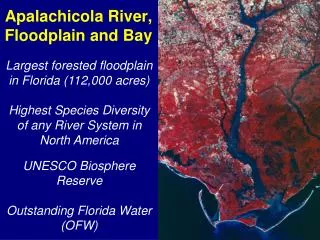
Apalachicola River, Floodplain and Bay. Largest forested floodplain in Florida (112,000 acres) Highest Species Diversity of any River System in North America UNESCO Biosphere Reserve Outstanding Florida Water (OFW).

E N D
Apalachicola River, Floodplain and Bay Largest forested floodplain in Florida (112,000 acres) Highest Species Diversity of any River System in North America UNESCO Biosphere Reserve Outstanding Florida Water (OFW)
ProductivityHarvest $200 million Local Seafood Industry, 90% of Florida Oysters, and 10% of US oysters, plus shrimp, crab and finfish. In 1994, Five Million lbs. of Seafood were produced from the Apalachicola Bay region. 90% of all harvested species must spend some part of their life cycle inshore on the marsh and seagrass environment, even the grouper caught offshore must rely on this healthy environment.
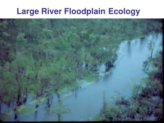
Habitat Diversity Apalachicola River Floodplain hosts the highest biodiversity of any River System in North America 50 species of mammals 1300 species of plants 40 species of amphibians80 species of reptiles 300 species of birds See Apalachicola National Estuarine Research Reserve info
Natural Features of river and floodplain Swamp Cut bank Main channel Slough Point Bar used for Disposal Site Levee
Forest Types Distributed by Elevation Upland High Bottomland Hardwoods Low Bottomland Hardwoods Swamps Floodplain slough Main channel
River Level Controls Water in Floodplain Upland High Bottomland Hardwoods Low Bottomland Hardwoods Swamps Floodplain slough Main channel
River Level Controls Water in Floodplain Upland High Bottomland Hardwoods Low Bottomland Hardwoods Swamps Floodplain slough Main channel
River Level Controls Water in Floodplain Upland High Bottomland Hardwoods Low Bottomland Hardwoods Swamps Floodplain slough Main channel
River Level Controls Water in Floodplain Upland High Bottomland Hardwoods Low Bottomland Hardwoods Swamps Floodplain slough Main channel
High and Low Water Seasons(before 1954) Upland High Bottomland Hardwoods Low Bottomland Hardwoods Swamps Early Spring Summer Fall Floodplain slough Severe drought Main channel
2007 Flow in relation to Average Flow Apalachicola River at Chattahoochee, FL Average flow 1922-2007 2007 flow
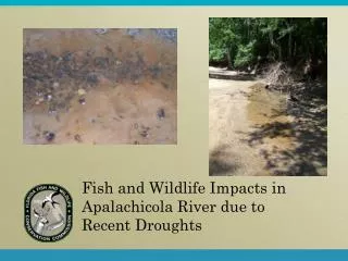
Fish trapped in floodplain will die if water dries up in isolated pools
Stagnant conditions develop if slough are isolated for long periods
Summary of Major Impacts: DECLINING RIVER STAGE Down cutting & Widening Woody debris removal Loss of Fish Habitat Reduced flow DRYING OUT OF FLOODPLAIN FOREST Decrease in Forests Density Loss of 4 million trees Disconnected Sloughs DECLINING SEAFOOD HARVEST River functions drives the Bay Loss of Nutrients and increased Salinity Chain reaction thru Food Chain
Flow ComparisonApalachicola River at Chattahoochee, Florida Pre-Dam Post-Dam 1923-1955 33-yr period before filling of Lanier 1975-2007 33-yr period after filling of West Point
Pre-Dam FlowsFor Groups of Years Ranked by Average Annual Flow
Pre-Dam FlowsFor Groups of Years Ranked by Average Annual Flow
Pre-Dam Vs Post-Dam Annual Rainfall Unchanged 10% LESS annual flow (30% LESS Apr-Aug flow)
Pre-Dam Vs Post-Dam Annual Rainfall Unchanged 18% LESS annual flow (38% LESS Apr-Aug flow)