Download
1 / 39
390 likes | 766 Views
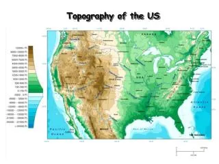
Topography of the US. The Contour of the US. Mt Whitney 14,495 Cali. Mt Mitchell 6,684 NC. Topography of the Northeast. New York’s Canals. A New England Fall . The back roads of Vermont. Kancamagus Highway, Maine. Covered Bridge over the Connecticut River. Topography of the Southeast.

E N D
The Contour of the US Mt Whitney 14,495 Cali Mt Mitchell 6,684 NC
A New England Fall The back roadsof Vermont Kancamagus Highway, Maine Covered Bridge over the Connecticut River
Bodies of Water Great Salt Lake Chesapeake Bay LakeOkeechobee
Rivers St. Lawrence R. Columbia R. Hudson R. Missouri R. Potomac R. Mississippi R. Ohio R. Colorado R. Arkansas R. Rio Grande R. Yukon R.
The Mississippi: America’s Great River Road • The “Big Muddy”. • 2,350 miles. • Draining all or part of 31 states & 2 Canadian provinces. • Covers 40% of the U. S.
Great Salt Lake • 2000 square miles. • 10’ – 28’ deep. • 6 times saltier than the oceans.
Mountains & Plateaus Adirondack Mts. Cascade Mts. Rocky Mts. Appalachian Mts. Sierra Nevada Mts. ^ Mt. Whitney ^ Pike’s Peak ^ Mt. McKinley Alaskan Range
Plains GreatBasin Central Plains Atlantic Coastal Plains Gulf Coastal Plains
Deserts Death Valley Mohave Desert
Death Valley, CA • 3.3 million acres. • 95% wilderness.
Completed Map St. Lawrence R. Columbia R. Adirondack Mts. Cascade Mts. Hudson R. Missouri R. Rocky Mts. Great Basin Potomac R. Cumberland Plateau Great Salt Lake Mississippi R. Chesapeake Bay Central Plains Appalachian Mts. Sierra Nevada Mts. ^ Mt. Whitney Ohio R. Colorado R. ^ Pike’s Peak Death Valley Atlantic Coastal Plains Arkansas R. Mohave Desert Gulf Coastal Plains LakeOkeechobee Rio Grande R. Yukon R. ^ Mt. McKinley Alaskan Range
Seismography Data: 1977-1997 Earthquakes!
US National Parks (1) Grand Teton National Park, WY Glacier National Park, MT Mt. Rushmore National Park, SD
US National Parks (2) Everglades National Park, FL Yellowstone National Park, MT Grand Canyon National Park, AZ
US National Parks (3) Yosemite National Park, CA Acadia National Park, ME Natural Bridges National Park, UT


![READ⚡[PDF]✔ The Topography of Tears](https://cdn7.slideserve.com/13190351/slide1-dt.jpg)