Topography around the World
110 likes | 234 Views
Discover the importance of topographic maps for engineers, hikers, and more. Learn how landscapes are shaped and why topography matters. Explore global topography from Chicago to Mexico City.

Topography around the World
E N D
Presentation Transcript
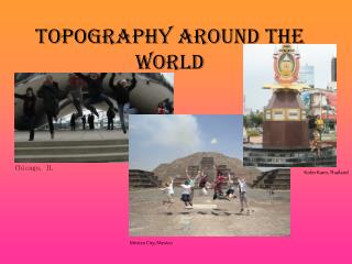
Topography around the World Chicago, IL Kohn Kaen, Thailand Mexico City, Mexico
Community Service International Friends Host-Families Performing Arts
WHAT DOES THIS HAVE TO DO WITH SCIENCE? - No, I’m not Amish, but I live in Pennsylvania Dutch-country • Yes , I have electricity • Yes I have a car • But the best thing about living in PA Dutch country is…
So, I decided to bake a cake… Philadelphia, PA: 0-136 m above sea level Denver: 1 mile above sea level Dallas: 430 ft (131 m)
Just awana mile • I wish I would have had one of these!! McNaught, M (2008, March 11). TOPOGRAPHIC MAPS. Retrieved November 6, 2008, from Mount Union College Geology Web site: http://raider.muc.edu/~mcnaugma/Topographic%20Maps/topomapindexpage.htm
Uses of Topographic Maps • Why don’t we just use a picture? • Who can use it? • engineers, foresters, land use planners, hikers, ... virtually anyone who travels outdoors
“the cross sectional shape of a valley stream valleys in mountainous areas is usually "V" shaped. This shaped is changed when a glacier flows down the valley. The bottom of the valley will be rounded while the sides of the valley will be steepened. The result is a U shaped valley with steep sides and a rounded valley”
Why do we care? • Who in here sleds? • Skiers or boarders?