Download
1 / 23
230 likes | 262 Views
Enhancing hydrologic science by facilitating user access to more and better data for testing hypotheses and analyzing processes through the use of an observations data model.

E N D
Using an Observations Data Model in Hydrologic Information Systems David G Tarboton Jeffery S Horsburgh David R. Maidment Ilya Zaslavsky Support EAR 0622374 http://www.cuahsi.org/his.html
CUAHSI Hydrologic Information System Models Databases Analysis Goal: Enhance hydrologic science by facilitating user access to more and better data for testing hypotheses and analyzing processes • Advancement of water science is critically dependent on integration of water information • It is as important to represent hydrologic environments precisely with data as it is to represent hydrologic processes with equations Water quantity and quality Rainfall & Snow Soil water Meteorology Remote sensing
Why an Observations Data Model • Syntactic heterogeneity (File types and formats) • Semantic heterogeneity • Language for observation attributes (structural) • Language to encode observation attribute values (contextual) • Publishing and sharing research data • Metadata to facilitate unambiguous interpretation • Enhance analysis capability
What are the basic attributes to be associated with each single data value and how can these best be organized?
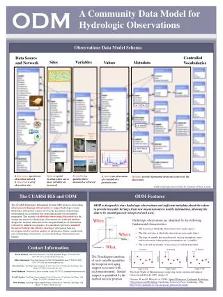
Point Observations Information Model Utah State Univ Data Source GetSites Little Bear River Network GetSiteInfo Little Bear River at Mendon Rd Sites GetVariables GetVariableInfo Dissolved Oxygen Variables GetValues 9.78 mg/L, 1 October 2007, 6PM Values {Value, Time, Qualifier, Offset} • A data source operates an observation network • A network is a set of observation sites • A site is a point location where one or more variables are measured • A variable is a property describing the flow or quality of water • A value is an observation of a variable at a particular time • A qualifier is a symbol that provides additional information about the value • An offset allows specification of measurements at various depths in water Horsburgh, J. S., D. G. Tarboton, D. R. Maidment and I. Zaslavsky, (2008), "A Relational Model for Environmental and Water Resources Data," Water Resources Research (in press).
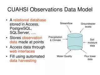
Streamflow Groundwater levels Precipitation & Climate Soil moisture data Time Water Quality Flux tower data Space Variables CUAHSI Observations Data Model • A relational database at the single observation level (atomic model) • Stores observation data made at points • Metadata for unambiguous interpretation • Traceable heritage from raw measurements to usable information • Standard format for data sharing • Cross dimension retrieval and analysis
CUAHSI Observations Data Model http://www.cuahsi.org/his/odm.html
Site Attributes SiteCode, e.g. NWIS:10109000 SiteName, e.g. Logan River Near Logan, UT Latitude, Longitude Geographic coordinates of site LatLongDatum Spatial reference system of latitude and longitude Elevation_m Elevation of the site VerticalDatum Datum of the site elevation Local X, Local Y Local coordinates of site LocalProjection Spatial reference system of local coordinates PosAccuracy_m Positional Accuracy State, e.g. Utah County, e.g. Cache
Feature Observations Data Model Waterbody Watershed HydroPoint HydroID HydroID HydroID HydroCode HydroCode HydroCode * FType DrainID FType Name AreaSqKm Name AreaSqKm JunctionID JunctionID JunctionID NextDownID * * ComplexEdgeFeature SimpleJunctionFeature HydroEdge HydroJunction HydroJunction HydroJunction 1 HydroID 1 HydroID HydroID HydroID HydroCode HydroCode HydroCode HydroCode ReachCode NextDownID NextDownID NextDownID Name LengthDown LengthDown LengthDown LengthKm HydroNetwork DrainArea DrainArea DrainArea LengthDown FType FType FType FlowDir Enabled Enabled Enabled FType AncillaryRole AncillaryRole AncillaryRole EdgeType Enabled EdgeType Flowline Shoreline Independent of, but can be coupled to Geographic Representation Arc Hydro ODM 1 Sites 1 SiteID SiteCode SiteName OR Latitude Longitude … CouplingTable 1 SiteID HydroID 1
Variable attributes Cubic meters per second Flow m3/s VariableName, e.g. discharge VariableCode, e.g. NWIS:0060 SampleMedium, e.g. water ValueType, e.g. field observation, laboratory sample IsRegular, e.g. Yes for regular or No for intermittent TimeSupport (averaging interval for observation) DataType, e.g. Continuous, Instantaneous, Categorical GeneralCategory, e.g. Climate, Water Quality NoDataValue, e.g. -9999
Offset OffsetValue Distance from a datum or control point at which an observation was made OffsetType defines the type of offset, e.g. distance below water level, distance above ground surface, or distance from bank of river
Implementation in WATERS Network Information System National Hydrologic Information Server San Diego Supercomputer Center • 11 WATERS Network test bed projects • 16 ODM instances (some test beds have more than one ODM instance) • Data from 1246 sites, of these, 167 sites are operated by WATERS investigators
Utah – Little Bear River and Mud Lake Turbidity Continuous turbidity observations at the Little Bear River at Mendon Road from two different turbidity sensors.
Florida – Santa Fe Watershed Nitrate Nitrogen (mg/L) Millpond Spring PI: Wendy Graham, ….; DM: Kathleen McKee, Mark Newman
Loading data into ODM OD Data Loader • Interactive OD Data Loader (OD Loader) • Loads data from spreadsheets and comma separated tables in simple format • Scheduled Data Loader (SDL) • Loads data from datalogger files on a prescribed schedule. • Interactive configuration • SQL Server Integration Services (SSIS) • Microsoft application accompanying SQL Server useful for programming complex loading or data management functions SDL SSIS
Managing Data Within ODM - ODM Tools • Query and export – export data series and metadata • Visualize – plot and summarize data series • Edit – delete, modify, adjust, interpolate, average, etc.
Dynamic controlled vocabulary moderation system ODM Data Manager ODM Website ODM Tools ODM Controlled Vocabulary Moderator XML Master ODM Controlled Vocabulary Local ODM Database ODM Controlled Vocabulary Web Services Local Server http://water.usu.edu/cuahsi/odm/cv.aspx
Summary • Syntactic consistency (File types and formats) • Semantic consistency • Language for observation attributes (structural) • Language to encode observation attribute values (contextual) • A national network of consistent data • Enhanced data availability • Metadata to facilitate unambiguous interpretation • Enhanced analysis capability
Future Considerations • Additional data types (grid, image etc.) • Additional catalog sets to enhance discovery • Unit standardization and conversion • Ownership, security, authentication, provenance • Improve controlled vocabulary constraints to enhance integrity
HIS Websitehttp://www.cuahsi.org/his • Project Team – Introduces members of the HIS Team • Data Access System for Hydrology – Web map interface supporting data discovery and retrieval • Prototype Web Services – WaterOneFlow web services facilitating downlad of time series data from numerous national repositories of hydrologic data • Observations Data Model – Relational database schema for hydrologic observations • HIS Tools – Links to end-user applications developed to support HIS • Documentation and Reports – Status reports, specifications, workbooks and links related to HIS • Feedback – Let us know what you think • Austin Workshop – Material from WATERS workshop in Austin